Country:
Region:
City:
Latitude and Longitude:
Time Zone:
Postal Code:
IP information under different IP Channel
ip-api
Country
Region
City
ASN
Time Zone
ISP
Blacklist
Proxy
Latitude
Longitude
Postal
Route
Luminati
Country
Region
bw
City
furtwangenimschwarzwald
ASN
Time Zone
Europe/Berlin
ISP
Stiegeler Internet Service GmbH
Latitude
Longitude
Postal
IPinfo
Country
Region
City
ASN
Time Zone
ISP
Blacklist
Proxy
Latitude
Longitude
Postal
Route
db-ip
Country
Region
City
ASN
Time Zone
ISP
Blacklist
Proxy
Latitude
Longitude
Postal
Route
ipdata
Country
Region
City
ASN
Time Zone
ISP
Blacklist
Proxy
Latitude
Longitude
Postal
Route
Popular places and events near this IP address

Brigach
River in Germany
Distance: Approx. 4033 meters
Latitude and longitude: 48.10667,8.28083
The Brigach is the shorter of two streams that jointly form the river Danube in Baden-Württemberg, Germany. The Brigach has its source at 925 m (3,035 ft) above sea level within St. Georgen in the Black Forest.

Sankt Georgen im Schwarzwald
Town in Baden-Württemberg, Germany
Distance: Approx. 371 meters
Latitude and longitude: 48.12472222,8.33083333
Sankt Georgen im Schwarzwald (Low Alemannic: Sanderge) is a town in Southwestern Baden-Württemberg, Germany and belongs to Schwarzwald-Baar County.

St. George's Abbey in the Black Forest
Distance: Approx. 456 meters
Latitude and longitude: 48.125,8.33333333
St. George's Abbey in the Black Forest (Kloster Sankt Georgen im Schwarzwald) was a Benedictine monastery in St. Georgen im Schwarzwald in the southern Black Forest in Baden-Württemberg, Germany.
Tennenbronn
Distance: Approx. 7046 meters
Latitude and longitude: 48.18333333,8.35
Tennenbronn is a district of Schramberg in the district of Rottweil, in Baden-Württemberg, Germany.

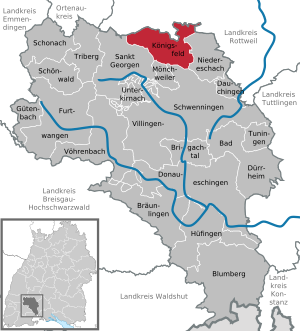
Königsfeld im Schwarzwald
Municipality in Baden-Württemberg, Germany
Distance: Approx. 7018 meters
Latitude and longitude: 48.13833333,8.42138889
Königsfeld im Schwarzwald (Low Alemannic: Kinnigsfeld) is a town in the district of Schwarzwald-Baar in Baden-Württemberg in Germany. It is the northernmost town of the district Schwarzwald Baar. Königsfeld has six boroughs (Königsfeld, Neuhausen, Erdmannsweiler, Buchenberg, Burgberg and Weiler).

Mönchweiler
Municipality in Baden-Württemberg, Germany
Distance: Approx. 7385 meters
Latitude and longitude: 48.1,8.42444444
Mönchweiler is a municipality in the district of Schwarzwald-Baar in Baden-Württemberg in Germany.

Unterkirnach
Municipality in Baden-Württemberg, Germany
Distance: Approx. 5376 meters
Latitude and longitude: 48.07888889,8.36472222
Unterkirnach is a municipality in the district of Schwarzwald-Baar in Baden-Württemberg in Germany, situated in the Black Forest and 40 km east of Freiburg.

Stöcklewald
Distance: Approx. 6580 meters
Latitude and longitude: 48.09167,8.25389
The Stöcklewald is a mountain, 1,068.2 m above sea level (NHN), in the southern part of the Central Black Forest in Germany between the towns of Furtwangen and Triberg, each about 5 kilometres distant, in the county of Schwarzwald-Baar-Kreis. Towards the north, the Black Forest only exceeds this height again in the area of the Schliffkopf and the Hornisgrinde.
Kirnach (Brigach)
River in Germany
Distance: Approx. 5420 meters
Latitude and longitude: 48.07916667,8.36666667
Kirnach is a river of Baden-Württemberg, Germany. It is a right tributary of the Brigach near Villingen-Schwenningen. It passes through Unterkirnach.
Sammlung Grässlin
Art collection in Germany
Distance: Approx. 700 meters
Latitude and longitude: 48.12666667,8.33555556
The Sammlung Grässlin is an art collection in Germany. The works can be seen in its museum in Sankt Georgen (Schwarzwald).

Triberg Gallows
Distance: Approx. 5849 meters
Latitude and longitude: 48.09777778,8.26011111
The Triberg Gallows (German: Triberger Galgen) is a double gallows on the heights known as Hochgericht (1,020.6 m above sea level (NHN)) on the K 5728 county road that runs from Schönwald to Villingen, and in the county of Schwarzwald-Baar-Kreis in the German state of Baden-Württemberg. A map from Benedictine Abbey of St. George in the Black Forest indicates that, on the present site of the Blood Court, a gallows was erected in the late 16th century.
Brigach (St. Georgen im Schwarzwald)
Village of St. Georgen im Schwarzwald in Baden-Württemberg, Germany
Distance: Approx. 3856 meters
Latitude and longitude: 48.10722222,8.28305556
Brigach is a village in the town of Sankt Georgen im Schwarzwald in the district of Schwarzwald-Baar-Kreis in the southwest German state of Baden-Württemberg. It has 910 inhabitants (2015).
Weather in this IP's area
broken clouds
4 Celsius
4 Celsius
2 Celsius
4 Celsius
1028 hPa
98 %
1028 hPa
930 hPa
10000 meters
1.17 m/s
2.1 m/s
93 degree
65 %
07:33:55
16:48:58