Country:
 Switzerland
Region:
City:
Latitude and Longitude:
Time Zone:
Postal Code:
IP information under different IP Channel
ip-api
Country
Region
City
ASN
Time Zone
ISP
Blacklist
Proxy
Latitude
Longitude
Postal
Route
IPinfo
Country
Region
City
ASN
Time Zone
ISP
Blacklist
Proxy
Latitude
Longitude
Postal
Route
MaxMind
Country
Region
City
ASN
Time Zone
ISP
Blacklist
Proxy
Latitude
Longitude
Postal
Route
Luminati
Country
CHRegion
so
City
balsthal
ASN
Time Zone
Europe/Zurich
ISP
Quickline AG
Latitude
Longitude
Postal
db-ip
Country
Region
City
ASN
Time Zone
ISP
Blacklist
Proxy
Latitude
Longitude
Postal
Route
ipdata
Country
Region
City
ASN
Time Zone
ISP
Blacklist
Proxy
Latitude
Longitude
Postal
Route
Popular places and events near this IP address

Oensingen
Municipality in Solothurn, Switzerland
Distance: Approx. 4438 meters
Latitude and longitude: 47.28333333,7.71666667
Oensingen is a municipality in the district of Gäu in the canton of Solothurn in Switzerland.

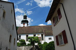
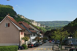
Balsthal
Municipality in Solothurn, Switzerland
Distance: Approx. 541 meters
Latitude and longitude: 47.31666667,7.7
Balsthal is a municipality in the district of Thal in the canton of Solothurn in Switzerland.

Thal District
Distance: Approx. 450 meters
Latitude and longitude: 47.31666667,7.69444444
Thal District is one of the ten districts of the canton of Solothurn in Switzerland, situated in the centre of the canton. Together with the Gäu District, it forms the Amtei (electoral district) of Thal-Gäu. It has a population of 14,752 (as of 31 December 2020).
Holderbank, Solothurn
Municipality in Solothurn, Switzerland
Distance: Approx. 4328 meters
Latitude and longitude: 47.33333333,7.75
Holderbank is a municipality in the district of Thal in the canton of Solothurn in Switzerland.

Laupersdorf
Municipality in Solothurn, Switzerland
Distance: Approx. 3484 meters
Latitude and longitude: 47.31666667,7.65
Laupersdorf is a municipality in the district of Thal in the canton of Solothurn in Switzerland.

Matzendorf
Municipality in Solothurn, Switzerland
Distance: Approx. 5243 meters
Latitude and longitude: 47.3,7.63333333
Matzendorf is a municipality in the district of Thal in the canton of Solothurn in Switzerland.
Mümliswil-Ramiswil
Municipality in Solothurn, Switzerland
Distance: Approx. 1452 meters
Latitude and longitude: 47.33333333,7.7
Mümliswil-Ramiswil is a municipality in the district of Thal in the canton of Solothurn in Switzerland.
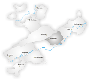
Gäu District
Distance: Approx. 3785 meters
Latitude and longitude: 47.288888,7.7139
Gäu District is one of the ten districts of the canton of Solothurn in Switzerland, situated in the centre of the canton. It has a population of 22,005 (as of 31 December 2020). Together with Thal District, it forms the Amtei (electoral district) of Thal-Gäu.

Passwang Pass
Distance: Approx. 5158 meters
Latitude and longitude: 47.35833333,7.65611111
Passwang Pass (elevation 1,204 m (3,950 ft)) is a high mountain pass in the Jura Mountains in the canton of Solothurn in Switzerland. It connects the southern part of the canton of Solothurn via Mümliswil-Ramiswil (south of the pass) and Beinwil, Solothurn (northern side) with the so-called Schwarzbubenland (officially Amtei Dorneck-Thierstein, consisting of the canton of Solothurn districts Thierstein and Dorneck) north of the Passwang mountain chain, and ultimately with the Laufen District in the canton of Basel-Landschaft.

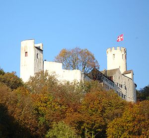
Neu-Falkenstein Castle
Distance: Approx. 1099 meters
Latitude and longitude: 47.32277778,7.71
Neu-Falkenstein Castle is a castle in the municipality of Balsthal of the Canton of Solothurn in Switzerland. It is a Swiss heritage site of national significance.
Neu-Bechburg Castle
Distance: Approx. 3120 meters
Latitude and longitude: 47.29722222,7.71861111
Neu Bechburg Castle is a castle in the municipality of Oensingen of the Canton of Solothurn in Switzerland. It is a Swiss heritage site of national significance.

Oensingen railway station
Railway station in Switzerland
Distance: Approx. 4103 meters
Latitude and longitude: 47.285,7.70988889
Oensingen railway station (German: Bahnhof Oensingen) is a railway station in the municipality of Oensingen, in the Swiss canton of Solothurn. The station is a keilbahnhof. It is located at the junction of the standard gauge Jura Foot line of Swiss Federal Railways and Oensingen–Balsthal line of Oensingen-Balsthal-Bahn.
Weather in this IP's area
light rain
14 Celsius
13 Celsius
12 Celsius
16 Celsius
1019 hPa
87 %
1019 hPa
956 hPa
10000 meters
0.45 m/s
0.53 m/s
61 degree
100 %
07:53:34
18:34:22