185.73.154.61 - IP Lookup: Free IP Address Lookup, Postal Code Lookup, IP Location Lookup, IP ASN, Public IP
Country:
Region:
City:
Location:
Time Zone:
Postal Code:
IP information under different IP Channel
ip-api
Country
Region
City
ASN
Time Zone
ISP
Blacklist
Proxy
Latitude
Longitude
Postal
Route
Luminati
Country
Region
sct
City
edinburgh
ASN
Time Zone
Europe/London
ISP
Fluency Communications Ltd
Latitude
Longitude
Postal
IPinfo
Country
Region
City
ASN
Time Zone
ISP
Blacklist
Proxy
Latitude
Longitude
Postal
Route
IP2Location
185.73.154.61Country
Region
scotland
City
westhill
Time Zone
Europe/London
ISP
Language
User-Agent
Latitude
Longitude
Postal
db-ip
Country
Region
City
ASN
Time Zone
ISP
Blacklist
Proxy
Latitude
Longitude
Postal
Route
ipdata
Country
Region
City
ASN
Time Zone
ISP
Blacklist
Proxy
Latitude
Longitude
Postal
Route
Popular places and events near this IP address

Westhill, Aberdeenshire
Town in Aberdeenshire, Scotland
Distance: Approx. 303 meters
Latitude and longitude: 57.154,-2.284
Westhill is a suburban town in Aberdeenshire, Scotland, located 7 miles (11 km) west of the city of Aberdeen.

Loch of Skene
Freshwater artificial loch in Aberdeenshire, Scotland
Distance: Approx. 4696 meters
Latitude and longitude: 57.1575,-2.35694444
Loch of Skene is a large lowland, freshwater loch in Aberdeenshire, Scotland. It lies approximately 1 mi (1.6 km) to the west of the village of Kirkton of Skene and 9 mi (14 km) west of Aberdeen. The loch is partially man-made, being dammed at its outflow on the southern shore to form a reservoir.

Skene Parish Church
Distance: Approx. 2880 meters
Latitude and longitude: 57.15916667,-2.32583333
Kingshill Parish Church is a congregation of the Church of Scotland in Skene, part of the Presbytery of North East and Northern Isles. The parish has two places of worship, Skene Church in Kirkton of Skene and Trinity Church in Westhill. The current minister is in vacancy.

Elrick
Place
Distance: Approx. 1004 meters
Latitude and longitude: 57.14814,-2.29416
Elrick (Scottish Gaelic: An Eilreig) is a small village on the A944 road 7+1⁄2 miles (12.1 km) west of the city of Aberdeen, Scotland. The name derives from a Gaelic word meaning a place where deer were driven for hunting. Elrick is also a common surname in the local area.

Kingswells
Human settlement in Scotland
Distance: Approx. 3518 meters
Latitude and longitude: 57.16,-2.223056
Kingswells is a village and suburb of Aberdeen, Scotland, situated west of the city and to the east of Westhill. Kingswells has existed as a village for centuries, but only beginning in the 1980s did it expand as a result of the boom in the oil industry. Kingswells accommodates many facilities suited for everybody and is famous for its spacious family homes amongst a leafy, affluent setting.

Westhill Academy
Secondary school in Westhill, Aberdeenshire, Scotland
Distance: Approx. 346 meters
Latitude and longitude: 57.1554,-2.2822
Westhill Academy is an Aberdeenshire Council secondary school in Westhill, near Aberdeen, Scotland, serving the Westhill, Elrick and Skene areas of Aberdeenshire. Its main feeder schools are Westhill Primary, Crombie Primary School, Elrick Primary and Skene Primary. School transport, before and after school, is provided for students who live in Skene.

Garlogie
Distance: Approx. 4757 meters
Latitude and longitude: 57.13333333,-2.35
Garlogie (Scottish Gaelic: Geàrr Lagaidh) is a roadside hamlet in Aberdeenshire, Scotland. It was, during the 19th century, the site of a textile milling settlement using water from Loch of Skene. The mill houses a beam engine and 1923 hydropower tubine.

Brimmond Hill
Distance: Approx. 3318 meters
Latitude and longitude: 57.172335,-2.238501
Brimmond Hill is a hill in Aberdeen, Scotland. The summit is the highest point within the Aberdeen City council area, at an elevation of 266 m (873 ft). The hill itself is situated in the area between Kingswells, Westhill, Blackburn and Dyce.

Kirkhill Forest
Distance: Approx. 5177 meters
Latitude and longitude: 57.194262,-2.241597
Kirkhill Forest is a forest in Scotland, situated to the north-west of Aberdeen, on the north side of the A96 between the villages of Dyce and Blackburn. Kirkhill is a working forest with a network of paths for walking, a permanent orienteering trail, and a mountain bike fun park.

Cullerlie stone circle
Stone circle in Aberdeenshire, Scotland
Distance: Approx. 5341 meters
Latitude and longitude: 57.12892,-2.35661
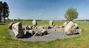
Cullerlie stone circle, also known as the Standing Stones of Echt, is a small stone circle situated near Echt, Aberdeenshire. It consists of eight irregular stones of red granite arranged at approximately equal intervals to form a circle of 10.2 m (33 ft) diameter, enclosing the same number of small cairns. The cairns are characterised by outer kerbs or rings of stones, with a double ring surrounding the central cairn and a single ring in the others.

Countesswells
Human settlement in Scotland
Distance: Approx. 4426 meters
Latitude and longitude: 57.136675,-2.2125404
Countesswells (Scottish Gaelic: Baile Cobhan an t-Eas) is an area of Aberdeen, Scotland.
Garlogie Beam Engine
Scottish steam engine, built in 1833
Distance: Approx. 5142 meters
Latitude and longitude: 57.139878,-2.3615573
The Garlogie Beam Engine is a steam powered beam engine, built in 1833, that once powered a woollen mill at Garlogie, Aberdeenshire. It is a rare survivor of the Industrial Revolution and the oldest steam engine of any kind still in its original location in Scotland. It contains what is believed to be the oldest cast iron engine beam in the world, dating from 1805.
Weather in this IP's area
overcast clouds
10 Celsius
8 Celsius
10 Celsius
11 Celsius
1025 hPa
88 %
1025 hPa
1009 hPa
10000 meters
4.12 m/s
120 degree
100 %