185.73.153.83 - IP Lookup: Free IP Address Lookup, Postal Code Lookup, IP Location Lookup, IP ASN, Public IP
Country:
Region:
City:
Location:
Time Zone:
Postal Code:
IP information under different IP Channel
ip-api
Country
Region
City
ASN
Time Zone
ISP
Blacklist
Proxy
Latitude
Longitude
Postal
Route
Luminati
Country
Region
sct
City
edinburgh
ASN
Time Zone
Europe/London
ISP
Fluency Communications Ltd
Latitude
Longitude
Postal
IPinfo
Country
Region
City
ASN
Time Zone
ISP
Blacklist
Proxy
Latitude
Longitude
Postal
Route
IP2Location
185.73.153.83Country
Region
scotland
City
isle of bute
Time Zone
Europe/London
ISP
Language
User-Agent
Latitude
Longitude
Postal
db-ip
Country
Region
City
ASN
Time Zone
ISP
Blacklist
Proxy
Latitude
Longitude
Postal
Route
ipdata
Country
Region
City
ASN
Time Zone
ISP
Blacklist
Proxy
Latitude
Longitude
Postal
Route
Popular places and events near this IP address

Rothesay
Town on the Isle of Bute, Scotland
Distance: Approx. 518 meters
Latitude and longitude: 55.83333333,-5.05
Rothesay ( ROTH-see; Scottish Gaelic: Baile Bhòid [ˈpalə ˈvɔːtʲ]) is the principal town on the Isle of Bute, in the council area of Argyll and Bute, Scotland. It lies along the coast of the Firth of Clyde. It can be reached by ferry from Wemyss Bay, which offers an onward rail link to Glasgow.

Rothesay Castle
Castle in Argyll and Bute, Scotland, UK
Distance: Approx. 56 meters
Latitude and longitude: 55.836461,-5.055041
Rothesay Castle is a ruined castle in Rothesay, the principal town on the Isle of Bute, in western Scotland. Located at NS086646, the castle has been described as "one of the most remarkable in Scotland", for its long history dating back to the beginning of the 13th century, and its unusual circular plan. The castle comprises a huge curtain wall, strengthened by four round towers, together with a 16th-century forework, the whole surrounded by a broad moat.

West Island Way
Distance: Approx. 1753 meters
Latitude and longitude: 55.83333333,-5.08333333
The West Island Way is a waymarked long distance footpath on the Isle of Bute. The route opened in September 2000 as part of Bute's millennium celebrations, and was the first waymarked long distance route on a Scottish island. As of 2018 it was estimated that between six and seven thousand people were using the trail each year.
Bute FM
Radio station in Rothesay
Distance: Approx. 179 meters
Latitude and longitude: 55.83638889,-5.05305556
Bute FM is a Community Radio station for the Isle of Bute, broadcasting in stereo on 96.5 FM and simultaneously broadcasting online via a live internet stream. For almost 100 hours per week the station broadcasts programmes produced by volunteer presenters, with the remaining airtime (broadcasting) occupied by an automated music playout system. The station operates on a not-for-profit basis for the benefit of the community, and is dependent on advertising, local fundraising and donations for its continued existence.
Balmory Hall
Victorian Italianate mansion on the Isle of Bute, Scotland
Distance: Approx. 2239 meters
Latitude and longitude: 55.823328,-5.029
Balmory Hall is a category A listed Victorian Italianate mansion located near Ascog in the Isle of Bute, Scotland, just west of Ascog House. The hall is set within 6 acres (2.4 ha) of gardens. It is run as a privately owned guesthouse and reportedly features a 7-course breakfast.
Rothesay Academy
Secondary school in Rothesay, Isle of Bute, Scotland
Distance: Approx. 1227 meters
Latitude and longitude: 55.8256,-5.0572
Rothesay Academy is a secondary school in the town of Rothesay on the Isle of Bute.
Loch Ascog
Reservoir in Rothesay, Scotland
Distance: Approx. 2205 meters
Latitude and longitude: 55.8178,-5.0448
Loch Ascog is a small reservoir on the east coast of the island of Bute, in the council area of Argyll and Bute, Scotland. The loch supplies water to the town of Rothesay and the fishing rights are held by the Isle of Bute Angling Association. Loch Ascog is 44.7 hectares (110 acres) in extent.

Kirk Dam
Reservoir in Bute, Scotland
Distance: Approx. 1961 meters
Latitude and longitude: 55.8196,-5.0641
Kirk Dam is an impounding dam, located 1.5 kilometres south of Rothesay, and is separated by a causeway from the much larger Loch Fad to the south-west. It was built to provide water to the cotton mills of the town, and is now the habitat for a variety of marshland birds. The earthfill dam is 6 metres high and records show it was constructed in the late 18th century.
Ardbeg, Bute
Distance: Approx. 1913 meters
Latitude and longitude: 55.85355,-5.06096
Ardbeg is a small settlement on the island of Bute in Scotland, in Argyll and Bute (grid reference NS0866). It is on the south side of Port Bannatyne. It developed largely in the 19th century as part of Rothesay's tourist boom.

Victoria Hospital, Rothesay
Hospital in Rothesay, Scotland
Distance: Approx. 735 meters
Latitude and longitude: 55.83,-5.0554
Victoria Hospital is a health facility in High Street, Rothesay, Scotland. It is managed by NHS Highland.

Rothesay Town Hall and County Buildings
Municipal building in Rothesay, Scotland
Distance: Approx. 133 meters
Latitude and longitude: 55.8364,-5.0538
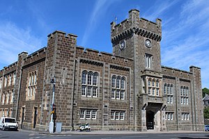
Rothesay Town Hall and County Buildings is a former municipal building in Castle Street, Rothesay, Scotland. The structure, which was the meeting place of Rothesay Burgh Council and of Bute County Council, is a Category B listed building.

West Pier Public Convenience
Toilet
Distance: Approx. 242 meters
Latitude and longitude: 55.83861111,-5.05444444
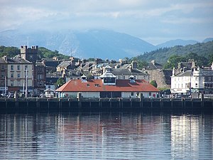
The West Pier Public Convenience or Victorian Toilets is a public toilet on the west pier of the harbour of Rothesay on the Isle of Bute. It opened in 1900, replacing previous cast-iron facilities, and was renovated in 1994. It is now a tourist attraction and listed for statutory protection.
Weather in this IP's area
moderate rain
10 Celsius
9 Celsius
9 Celsius
11 Celsius
1031 hPa
97 %
1031 hPa
1030 hPa
5920 meters
1.67 m/s
2.38 m/s
237 degree
100 %
