185.72.39.27 - IP Lookup: Free IP Address Lookup, Postal Code Lookup, IP Location Lookup, IP ASN, Public IP
Country:
 Denmark
Region:
City:
Location:
Time Zone:
Postal Code:
ISP:
ASN:
language:
User-Agent:
Proxy IP:
Blacklist:
IP information under different IP Channel
ip-api
Country
Region
City
ASN
Time Zone
ISP
Blacklist
Proxy
Latitude
Longitude
Postal
Route
db-ip
Country
Region
City
ASN
Time Zone
ISP
Blacklist
Proxy
Latitude
Longitude
Postal
Route
IPinfo
Country
Region
City
ASN
Time Zone
ISP
Blacklist
Proxy
Latitude
Longitude
Postal
Route
IP2Location
185.72.39.27Country
dkRegion
nordjylland
City
thisted
Time Zone
Europe/Copenhagen
ISP
Language
User-Agent
Latitude
Longitude
Postal
ipdata
Country
Region
City
ASN
Time Zone
ISP
Blacklist
Proxy
Latitude
Longitude
Postal
Route
Popular places and events near this IP address

Thisted Municipality
Municipality in North Jutland, Denmark
Distance: Approx. 5597 meters
Latitude and longitude: 56.9528,8.6028
Thisted Municipality (Danish: Thisted Kommune) is a kommune in North Jutland Region, Denmark. The municipality covers an area of 1,072 km², and has a total population of 42,989 (2024). The main town and the site of its municipal council is the town of Thisted.

Thisted
Town in Nordjylland, Denmark
Distance: Approx. 196 meters
Latitude and longitude: 56.95694444,8.69444444
Thisted is a town in the municipality of Thisted in the North Denmark Region of Denmark. It has a population of 13,522 (1 January 2024) and is located in Thy, in northwestern Jutland. Market town status was given to Thisted in 1500.

Vilsund Bridge
Distance: Approx. 8799 meters
Latitude and longitude: 56.88416667,8.63138889
Vilsund Bridge (Vilsundbroen) is a bascule arch bridge that crosses Vilsund between Mors and Thy in northwestern Jutland, Denmark. The bridge is 382 metres long, and the longest span is 30 metres. Vilsund Bridge was designed by Anker Engelund.

Langdos
Bronze Age burial mound in Jutland, Denmark
Distance: Approx. 1453 meters
Latitude and longitude: 56.959,8.672
Langdos, formerly also Langdaas (in Jutish, or Langdysse in Standard Danish, meaning "long mound") is the largest Bronze Age burial mound in Denmark, located in Thisted, Jutland. The burial mound is 140 metres long (originally 175 m) and was built between 1800 and 1000 BC. However, according to the listing at the Danish ministry of culture, it is a Stone Age mound dating from 3950 to 2800 BC. Part of the barrow has been damaged in the 1880s due to gravel extraction and slightly by the German Wehrmacht during the occupation of Denmark. The westernmost fifth of the barrow has since over 100 years been cut by a road and ploughed over, and in 1960 that part was excavated and sacrificed for a villa area.

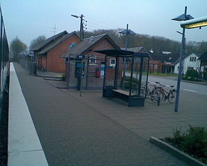
Thisted railway station
Railway station in Thisted Municipality, Denmark
Distance: Approx. 504 meters
Latitude and longitude: 56.95263889,8.68805556
Thisted station (Danish: Thisted Station or Thisted Banegård) is a railway station serving the town of Thisted in Thy, Denmark. The station is the northern terminus of the Thy Line from Struer to Thisted. The station opened in 1882 with the opening of the Thy Line.
Sjørring railway station
Railway station in Thisted Municipality, Denmark
Distance: Approx. 6496 meters
Latitude and longitude: 56.95194444,8.58805556
Sjørring station is a railway station serving the small railway town of Sjørring in Thy, Denmark. Sjørring station is located on the Thy Line from Struer to Thisted. The station was opened in 1882 with the opening of the Thy Line.

Hov Dås
Hill in Denmark containing barrows
Distance: Approx. 8305 meters
Latitude and longitude: 56.9908,8.8152
Hov Dås (before 1948 spelled Hov Daas) is a large hill in Denmark of prehistoric and bronze age interest because it contains a couple of long barrows type of bronze and prehistoric burial types, and tumulus on top. It is situated in Jutland, in the community of Thisted. It is 54 m wide and 3 m high.

Hillerslev
Village in North Jutland, Denmark
Distance: Approx. 6659 meters
Latitude and longitude: 57.01222222,8.72805556
Hillerslev is a village in Thy (district), northwestern Jutland in the Thisted Municipality, in North Jutland Region. As of 1 January 2024, it has a population of 368. It is located 16 kilometers southeast of Hanstholm, 37 km west of Fjerritslev and 7 km north of Thisted.
Weather in this IP's area
overcast clouds
2 Celsius
-4 Celsius
2 Celsius
2 Celsius
1041 hPa
69 %
1041 hPa
1039 hPa
10000 meters
8.24 m/s
10.76 m/s
68 degree
100 %