Country:
 Slovenia
Region:
City:
Latitude and Longitude:
Time Zone:
Postal Code:
IP information under different IP Channel
ip-api
Country
Region
City
ASN
Time Zone
ISP
Blacklist
Proxy
Latitude
Longitude
Postal
Route
IPinfo
Country
Region
City
ASN
Time Zone
ISP
Blacklist
Proxy
Latitude
Longitude
Postal
Route
MaxMind
Country
Region
City
ASN
Time Zone
ISP
Blacklist
Proxy
Latitude
Longitude
Postal
Route
Luminati
Country
SIASN
Time Zone
Europe/Ljubljana
ISP
UB330.net d.o.o.
Latitude
Longitude
Postal
db-ip
Country
Region
City
ASN
Time Zone
ISP
Blacklist
Proxy
Latitude
Longitude
Postal
Route
ipdata
Country
Region
City
ASN
Time Zone
ISP
Blacklist
Proxy
Latitude
Longitude
Postal
Route
Popular places and events near this IP address

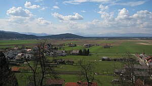
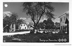
Mengeš
Town in Upper Carniola, Slovenia
Distance: Approx. 491 meters
Latitude and longitude: 46.16258333,14.56803056
Mengeš (pronounced [ˈmeːŋɡəʃ] ; German: Mannsburg) is a town in the Upper Carniola region of Slovenia. It is the seat of the Municipality of Mengeš. It is located approximately fifteen kilometers from the Slovenian capital of Ljubljana.

Loka pri Mengšu
Place in Upper Carniola, Slovenia
Distance: Approx. 1650 meters
Latitude and longitude: 46.15204167,14.56383889
Loka pri Mengšu (pronounced [ˈloːka pɾi ˈmeːŋɡʃu]; German: Laak bei Mannsburg) is a village in the Municipality of Mengeš in the Upper Carniola region of Slovenia.

Topole, Mengeš
Place in Upper Carniola, Slovenia
Distance: Approx. 1920 meters
Latitude and longitude: 46.17846389,14.55637778
Topole (pronounced [tɔˈpɔːlɛ]) is a settlement in the Municipality of Mengeš in the Upper Carniola region of Slovenia.
Homec, Domžale
Place in Upper Carniola, Slovenia
Distance: Approx. 2308 meters
Latitude and longitude: 46.17672778,14.59796944
Homec (pronounced [ˈxɔːməts]; German: Homez) is a settlement north of Domžale in the Upper Carniola region of Slovenia. The parish church in the settlement is dedicated to the Nativity of Mary.
Preserje pri Radomljah
Place in Upper Carniola, Slovenia
Distance: Approx. 1529 meters
Latitude and longitude: 46.16618333,14.59260556
Preserje pri Radomljah (pronounced [preˈsɛːrjɛ pri ˈraːdɔmljax]) is a suburbanized settlement on the right bank of the Kamnik Bistrica River in the Municipality of Domžale in the Upper Carniola region of Slovenia.

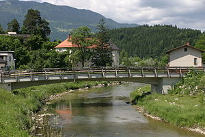
Rodica, Domžale
Place in Upper Carniola, Slovenia
Distance: Approx. 2541 meters
Latitude and longitude: 46.14819444,14.59429167
Rodica (pronounced [ɾɔˈdiːtsa]) is a settlement on the outskirts of Domžale in the Upper Carniola region of Slovenia. It includes the hamlet of Groblje (German: Ebensfeld).
Spodnje Jarše, Domžale
Place in Upper Carniola, Slovenia
Distance: Approx. 2436 meters
Latitude and longitude: 46.15153333,14.59711667
Spodnje Jarše (pronounced [ˈspoːdnjɛ ˈjaːɾʃɛ]; German: Unterjarsche) is a settlement on the right bank of the Kamnik Bistrica River in the Municipality of Domžale in the Upper Carniola region of Slovenia.
Srednje Jarše
Place in Upper Carniola, Slovenia
Distance: Approx. 1916 meters
Latitude and longitude: 46.15592778,14.59345833
Srednje Jarše (pronounced [ˈsɾeːdnjɛ ˈjaːɾʃɛ]; German: Mitterjarsche) is a settlement on the right bank of the Kamnik Bistrica River just north of Domžale, in the Upper Carniola region of Slovenia.
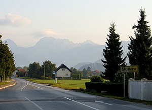
Škrjančevo
Place in Upper Carniola, Slovenia
Distance: Approx. 2729 meters
Latitude and longitude: 46.16803611,14.60800278
Škrjančevo (pronounced [ʃkəˈɾjaːntʃɛʋɔ]) is a settlement on the left bank of the Kamnik Bistrica River south of Radomlje in the Municipality of Domžale in the Upper Carniola region of Slovenia.
Zgornje Jarše, Domžale
Place in Upper Carniola, Slovenia
Distance: Approx. 1376 meters
Latitude and longitude: 46.16265,14.59016667
Zgornje Jarše (pronounced [ˈzɡóːrnjɛ ˈjàːrʃɛ]; German: Oberjarsche) is a settlement on the right bank of the Kamnik Bistrica River north of Domžale and east of Mengeš in the Upper Carniola region of Slovenia.

Municipality of Mengeš
Municipality of Slovenia
Distance: Approx. 490 meters
Latitude and longitude: 46.16666667,14.56666667
The Municipality of Mengeš (pronounced [ˈmeːŋɡəʃ] ; Slovene: Občina Mengeš) is a municipality in the eastern part of the traditional region of Upper Carniola in central Slovenia. The seat of the municipality is the town of Mengeš. It is located approximately fifteen kilometers from the Slovenian capital of Ljubljana.
Municipality of Nazarje
Municipality of Slovenia
Distance: Approx. 2736 meters
Latitude and longitude: 46.19,14.57
The Municipality of Nazarje (pronounced [ˈnaːzaɾjɛ]; Slovene: Občina Nazarje) is a municipality in Slovenia. It lies along the Dreta River. The seat of the municipality is the town of Nazarje.
Weather in this IP's area
moderate rain
10 Celsius
10 Celsius
9 Celsius
12 Celsius
1013 hPa
91 %
1013 hPa
975 hPa
10000 meters
4.63 m/s
320 degree
75 %
06:41:23
19:11:47