Country:
Region:
City:
Latitude and Longitude:
Time Zone:
Postal Code:
IP information under different IP Channel
ip-api
Country
Region
City
ASN
Time Zone
ISP
Blacklist
Proxy
Latitude
Longitude
Postal
Route
Luminati
Country
ASN
Time Zone
Europe/Paris
ISP
Claranet Limited
Latitude
Longitude
Postal
IPinfo
Country
Region
City
ASN
Time Zone
ISP
Blacklist
Proxy
Latitude
Longitude
Postal
Route
db-ip
Country
Region
City
ASN
Time Zone
ISP
Blacklist
Proxy
Latitude
Longitude
Postal
Route
ipdata
Country
Region
City
ASN
Time Zone
ISP
Blacklist
Proxy
Latitude
Longitude
Postal
Route
Popular places and events near this IP address

Bastille
Former Parisian fortress
Distance: Approx. 366 meters
Latitude and longitude: 48.85333,2.36917
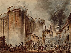
The Bastille (, French: [bastij] ) was a fortress in Paris, known as the Bastille Saint-Antoine. It played an important role in the internal conflicts of France and for most of its history was used as a state prison by the kings of France. It was stormed by a crowd on 14 July 1789, in the French Revolution, becoming an important symbol for the French Republican movement.

Bastille station (Paris Métro)
Paris Métro station
Distance: Approx. 394 meters
Latitude and longitude: 48.853082,2.369077
Bastille (French pronunciation: [bastij] ) is a station on Line 1, Line 5 and Line 8 of the Paris Métro. Located under the Place de la Bastille and near the former location of the Bastille, it is situated on the border of the 4th, 11th and 12th arrondissement.

Chemin Vert station
Paris Métro station
Distance: Approx. 224 meters
Latitude and longitude: 48.856778,2.368348
Chemin Vert (French pronunciation: [ʃəmɛ̃ vɛʁ]) is a station of the Paris Métro on Line 8, named after the Rue de Chemin Vert.

Storming of the Bastille
Major event of the French Revolution
Distance: Approx. 394 meters
Latitude and longitude: 48.85305556,2.36916667
The Storming of the Bastille (French: Prise de la Bastille [pʁiz də la bastij]) occurred in Paris, France, on 14 July 1789, when revolutionary insurgents attempted to storm and seize control of the medieval armoury, fortress and political prison known as the Bastille. After four hours of fighting and 94 deaths, the insurgents were able to enter the Bastille. The governor de Launay and several members of the garrison were killed after surrender.

Bréguet–Sabin station
Metro station in Paris, France
Distance: Approx. 102 meters
Latitude and longitude: 48.856,2.37
Bréguet–Sabin (French pronunciation: [bʁeɡɛ sabɛ̃]) is a station on Line 5 of the Paris Métro, located in the 11th arrondissement of Paris.

Porte Saint-Antoine
Demolished city gate of Paris, France
Distance: Approx. 368 meters
Latitude and longitude: 48.85353,2.36859
The Porte Saint-Antoine was one of the gates of Paris. There were two gates named the Porte Saint-Antoine, both now demolished, of which the best known was that guarded by the Bastille, on the site now occupied by the start of the Rue de la Bastille in the 4th arrondissement of Paris.
Charlie Hebdo shooting
2015 terrorist attack in Paris, France
Distance: Approx. 338 meters
Latitude and longitude: 48.85925,2.37025
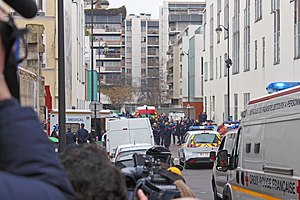
On 7 January 2015, at about 11:30 a.m. in Paris, France, the employees of the French satirical weekly magazine Charlie Hebdo were targeted in a terrorist shooting attack by two French-born Algerian Muslim brothers, Saïd Kouachi and Chérif Kouachi. Armed with rifles and other weapons, the duo murdered 12 people and injured 11 others; they identified themselves as members of al-Qaeda in the Arabian Peninsula, which claimed responsibility for the attack.

Rue Nicolas-Appert
Street in Paris, France
Distance: Approx. 310 meters
Latitude and longitude: 48.859,2.3703
The Rue Nicolas-Appert is a street in the 11th arrondissement of Paris, France.

Hôpital des Enfants-Trouvés
Former hospital for abandoned children
Distance: Approx. 368 meters
Latitude and longitude: 48.853,2.371
The Hôpital des Enfants-Trouvés was an institution of Paris established to take care of abandoned children. It was founded by Vincent de Paul in 1638.

Fontaine de la Régénération
Distance: Approx. 392 meters
Latitude and longitude: 48.8531,2.3691
The fontaine de la Régénération or fontaine d'Isis is a monument erected in 1793 at the former site of the Bastille in Paris, during a festival to commemorate the anniversary of 10 August, 1792. It featured a statue of goddess Isis flanked by two lions, with water springing from her breasts.
Synagogue Don Isaac Abravanel
Distance: Approx. 366 meters
Latitude and longitude: 48.856,2.3763
The Synagogue Don Isaac Abravanel, also known as the Synagogue de la Roquette, is an Orthodox Jewish congregation and synagogue, located in the XIe arrondissement of Paris, France. Designed by architects Alexandre Persitz and Arthur-Georges Héaume in the Modernist style, the synagogue was built in 1962 for Jews who emigrated to France from Algeria, Morocco and Tunisia as a result of decolonization. The congregation worships in the Sephardi rite.

Synagogue des Tournelles
Synagogue in Tournelles, France
Distance: Approx. 335 meters
Latitude and longitude: 48.8553,2.367
The Synagogue des Tournelles (French: Synagogue de la rue des Tournelles) is an Orthodox Jewish congregation and synagogue, located on the Rue des Tournelles, in the Marais district, in the IVe arrondissement of Paris, France. The building was dedicated on 15 September 1876, during Jewish New Year celebrations.
Weather in this IP's area
light rain
11 Celsius
10 Celsius
10 Celsius
11 Celsius
1011 hPa
94 %
1011 hPa
1006 hPa
7000 meters
6.71 m/s
6.71 m/s
230 degree
100 %
08:04:44
17:07:04

