185.68.98.109 - IP Lookup: Free IP Address Lookup, Postal Code Lookup, IP Location Lookup, IP ASN, Public IP
Country:
Region:
City:
Location:
Time Zone:
Postal Code:
ISP:
ASN:
language:
User-Agent:
Proxy IP:
Blacklist:
IP information under different IP Channel
ip-api
Country
Region
City
ASN
Time Zone
ISP
Blacklist
Proxy
Latitude
Longitude
Postal
Route
db-ip
Country
Region
City
ASN
Time Zone
ISP
Blacklist
Proxy
Latitude
Longitude
Postal
Route
IPinfo
Country
Region
City
ASN
Time Zone
ISP
Blacklist
Proxy
Latitude
Longitude
Postal
Route
IP2Location
185.68.98.109Country
Region
zuid-holland
City
hillegom
Time Zone
Europe/Amsterdam
ISP
Language
User-Agent
Latitude
Longitude
Postal
ipdata
Country
Region
City
ASN
Time Zone
ISP
Blacklist
Proxy
Latitude
Longitude
Postal
Route
Popular places and events near this IP address

Bennebroek
Village in North Holland, Netherlands
Distance: Approx. 3444 meters
Latitude and longitude: 52.32,4.6
Bennebroek (Dutch pronunciation: [ˈbɛnəbruk] ) is a village and former municipality in the northwest Netherlands, now part of Bloemendaal, North Holland. Before its merger in 2009, it was the smallest municipality in the Netherlands, covering an area of only 1.75 km².

Hillegom
Town and municipality in South Holland, Netherlands
Distance: Approx. 831 meters
Latitude and longitude: 52.28333333,4.58333333
Hillegom (Dutch: [ˌɦɪləˈɣɔm] ) is a town and municipality in the Western Netherlands, in the province of South Holland. Hillegom is part of an area called the Duin- en Bollenstreek ("Dune and Bulb Region"). As such, a large portion of the local economy was traditionally geared to the cultivation of bulb flowers.
Keukenhof
Flower garden in the Netherlands
Distance: Approx. 3326 meters
Latitude and longitude: 52.271256,4.546365
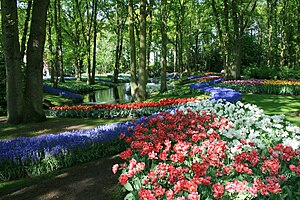
Keukenhof (Dutch pronunciation: [ˈkøːkə(n)ˌɦɔf]; lit. 'Kitchen garden'), also known as the Garden of Europe, is one of the world's largest flower gardens, situated in the municipality of Lisse, in the Netherlands. According to the official website, Keukenhof Park covers an area of 32 hectares (79 acres) and approximately 7 million flower bulbs are planted in the gardens annually. While it is widely known for its tulips, Keukenhof also features numerous other flowers, including hyacinths, daffodils, lilies, roses, carnations and irises.

Zwaanshoek
Village in North Holland, Netherlands
Distance: Approx. 3667 meters
Latitude and longitude: 52.31666667,4.61666667
Zwaanshoek is a village in the Dutch province of North Holland. It is a part of the municipality of Haarlemmermeer, and lies about 4 km west of Hoofddorp. On the other side of the canal lies the village of Bennebroek, which is connected to Zwaanshoek by a bridge.

Beinsdorp
Village in North Holland, Netherlands
Distance: Approx. 831 meters
Latitude and longitude: 52.28333333,4.58333333
Beinsdorp (Dutch pronunciation: [ˈbɛinzdɔr(ə)p]) is a village in the Dutch province of North Holland. It is a part of the municipality of Haarlemmermeer, and lies about 7 kilometres (4.3 mi) southwest of Hoofddorp along the Ringvaart, adjacent to Hillegom. Beinsdorp is named after a former island in the former Haarlemmer Lake.

Nieuwebrug, North Holland
Hamlet in North Holland, Netherlands
Distance: Approx. 1409 meters
Latitude and longitude: 52.28333333,4.6
Nieuwebrug is a hamlet in the western Netherlands. It is located in the municipality of Haarlemmermeer, North Holland, about 11 km west of Amsterdam. Nieuwebrug has a population of around 360.
De Vennip
Former municipality in the Netherlands
Distance: Approx. 3992 meters
Latitude and longitude: 52.268367,4.629021
De Vennip is a former municipality in the Netherlands, which at the time belonged to the province of South Holland. It consisted of a small area of land east of Hillegom, and a large part of the Haarlemmermeer lake, including the island of Beinsdorp (which is now the name of a village in the Haarlemmermeer polder). The area of the municipality was 38.61 km2, of which only 1.18 km2 was land.
Vogelenzang
Village in North Holland, Netherlands
Distance: Approx. 3159 meters
Latitude and longitude: 52.31888889,4.57666667
Vogelenzang is a village in the municipality of Bloemendaal, North Holland, Netherlands. The name "Vogelenzang" is Dutch for "bird song".
Hillegom railway station
Railway station in the Netherlands
Distance: Approx. 1787 meters
Latitude and longitude: 52.30277778,4.56583333
The railway station of Hillegom in the Netherlands is located on the railway line between Haarlem and Leiden. The first railway station in the town was opened in 1891, closed in 1898 and torn down in 1900. A second railway station was opened on a different location in 1898, when the first was closed.

Castlefest
Dutch fantasy festival
Distance: Approx. 3906 meters
Latitude and longitude: 52.267698,4.540143
Castlefest is a medieval/fantasy festival in the Netherlands, held in the gardens of Castle Keukenhof in Lisse since 2005.
De Oude Geleerde Man
Restaurant in Bennebroek, Netherlands
Distance: Approx. 3867 meters
Latitude and longitude: 52.32478611,4.59505
Restaurant De Oude Geleerde Man is a defunct restaurant in Bennebroek, in the Netherlands. It was a fine dining restaurant that was awarded one Michelin star in 1980 and retained that rating until 1990. The restaurant closed down shortly after 1991.
Arnoud, Hillegom
Township in South Holland, Netherlands
Distance: Approx. 2916 meters
Latitude and longitude: 52.26666667,4.56666667
Arnoud was a small township in the Dutch province of South Holland. The township was located between Hillegom and Lisse. It consisted of a single street (Arnoudstraat) and was developed as part of the creation of De Arnoud factory in 1904.
Weather in this IP's area
broken clouds
4 Celsius
-2 Celsius
3 Celsius
4 Celsius
1002 hPa
83 %
1002 hPa
1002 hPa
10000 meters
8.75 m/s
170 degree
75 %


