Country:
 Poland
Region:
City:
Latitude and Longitude:
Time Zone:
Postal Code:
IP information under different IP Channel
ip-api
Country
Region
City
ASN
Time Zone
ISP
Blacklist
Proxy
Latitude
Longitude
Postal
Route
IPinfo
Country
Region
City
ASN
Time Zone
ISP
Blacklist
Proxy
Latitude
Longitude
Postal
Route
MaxMind
Country
Region
City
ASN
Time Zone
ISP
Blacklist
Proxy
Latitude
Longitude
Postal
Route
Luminati
Country
PLASN
Time Zone
Europe/Warsaw
ISP
Toya sp.z.o.o
Latitude
Longitude
Postal
db-ip
Country
Region
City
ASN
Time Zone
ISP
Blacklist
Proxy
Latitude
Longitude
Postal
Route
ipdata
Country
Region
City
ASN
Time Zone
ISP
Blacklist
Proxy
Latitude
Longitude
Postal
Route
Popular places and events near this IP address

Tomb of the Unknown Soldier, Warsaw
Monument
Distance: Approx. 270 meters
Latitude and longitude: 52.24111111,21.01138889
The Tomb of the Unknown Soldier (Polish: Grób Nieznanego Żołnierza) is a monument in Warsaw, Poland, dedicated to the unknown soldiers who have given their lives for Poland. It is one of many such national tombs of unknowns that were erected after World War I, and the most important such monument in Poland. The monument, located at Piłsudski Square, is the only surviving part of the Saxon Palace that occupied the spot until World War II. Since 2 November 1925 the tomb houses the unidentified body of a young soldier who fell during the Defence of Lwów.

Saxon Palace
Building in Warsaw, Poland
Distance: Approx. 270 meters
Latitude and longitude: 52.24111111,21.01138889
The Saxon Palace (Polish: pałac Saski w Warszawie) was, before World War II, one of the most distinctive buildings in Warsaw, Poland. After the suppression of the 1944 Warsaw Uprising, the palace was destroyed by German armed forces as part of their deliberate destruction of Warsaw. After the Polish government announced plans to reconstruct the building, ground work commenced in August 2022.

Zachęta National Gallery of Art
Museum for Contemporary Polish Art in Warsaw, Poland
Distance: Approx. 196 meters
Latitude and longitude: 52.239,21.011
The Zachęta National Gallery of Art (Polish: Zachęta Narodowa Galeria Sztuki) is a contemporary art museum in the center of Warsaw, Poland. The Gallery's chief purpose is to present and support Polish contemporary art and artists. With numerous temporary exhibitions of well-known foreign artists, the gallery has also established itself internationally.
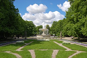
Saxon Garden
Public garden in Warsaw, Poland
Distance: Approx. 108 meters
Latitude and longitude: 52.24055556,21.00861111
The Saxon Garden (Polish: Ogród Saski) is a 15.5–hectare public garden in central (Śródmieście) Warsaw, Poland, facing Piłsudski Square. It is the oldest public park in the city. Founded in the late 17th century, it was opened to the public in 1727 as one of the first publicly accessible parks in the world.
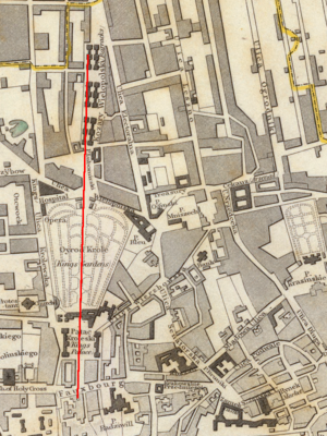
Saxon Axis
Distance: Approx. 109 meters
Latitude and longitude: 52.240556,21.008611
The Saxon Axis (Polish: Oś Saska) is a feature of the historical city centre of Warsaw. It is a line running from the Vistula through the Presidential Palace, the Krakowskie Przedmieście, Saxon Square, Saxon Palace, Saxon Garden, Lubomirski Palace to Plac Żelaznej Bramy. The idea was first proposed by August II of Poland, who intended to build a large Royal palace surrounded by a French-style garden.

Holy Trinity Church, Warsaw
Building in Warsaw, Poland
Distance: Approx. 255 meters
Latitude and longitude: 52.23861111,21.01166667
The Holy Trinity Church (Polish: Kościół Świętej Trójcy), also known as Zug's Protestant Church (Polish: Zbór Zuga), is a Lutheran church in central Warsaw, Poland, and one of two Augsburg Evangelical temples in the city. Designed by Szymon Bogumił Zug, it is one of the largest churches in Warsaw and one of the most notable for its round design.

Brühl Palace, Warsaw
Distance: Approx. 308 meters
Latitude and longitude: 52.242075,21.010305
The Brühl Palace (Polish: Pałac Brühla), formerly known as the Sandomierski Palace, was a palatial residence at Piłsudski Square in central Warsaw, Poland. It was one of the largest palaces and one of the finest examples of rococo architecture in pre-World War II Warsaw.

National Museum of Ethnography
Distance: Approx. 318 meters
Latitude and longitude: 52.23805556,21.01222222
The National Museum of Ethnography (Polish: Państwowe Muzeum Etnograficzne w Warszawie) is a museum of ethnography in Warsaw, Poland. It was established in 1888.

Assassination of Gabriel Narutowicz
1922 murder in Warsaw, Poland
Distance: Approx. 196 meters
Latitude and longitude: 52.239,21.011
Gabriel Narutowicz, the first president of Poland after regaining independence, was assassinated on 16 December 1922, five days after taking office, aged 57. He was fatally shot by Eligiusz Niewiadomski, an artist and art critic, while visiting an exhibition at Warsaw's Zachęta gallery.

Society for the Encouragement of Fine Arts in Warsaw
Arts organization in Warsaw, Poland
Distance: Approx. 196 meters
Latitude and longitude: 52.239,21.011
The Society for the Encouragement of Fine Arts in Warsaw (Towarzystwo Zachęty Sztuk Pięknych w Warszawie) was an independent arts organization founded in Warsaw, then Kingdom of Poland, in 1860. Its main goal was to support and popularize Polish art through active acquisitions, providing help for young artists through scholarships, as well as publishing and organizing exhibitions and art competitions, among other activities. The society remained active until the Nazi invasion of Poland in 1939 and was officially shut down in 1942.

Centrum Królewska
An office building in Warsaw, Poland
Distance: Approx. 180 meters
Latitude and longitude: 52.23805556,21.0075
The Centrum Królewska is an office building in Warsaw, Poland, located at 142 Marszałkowska Street, at the crossing with Królewska Street. It was opened in 2002.
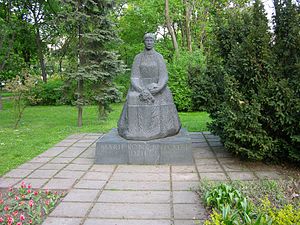
Maria Konopnicka Monument
Monument in Warsaw, Poland
Distance: Approx. 267 meters
Latitude and longitude: 52.2415,21.00591667
Maria Konopnicka Monument (Polish: Pomnik Marii Konopnickiej) is a syenite statue in Warsaw, Poland, within the Saxon Garden in the Downtown district. It is dedicated to Maria Konopnicka, a 19th- and 20th-century poet, novelist, children's writer, and activist for women's rights and the independence of Poland. It was designed by Stanisław Kulon, and unvailed on 22 May 1966.
Weather in this IP's area
clear sky
23 Celsius
23 Celsius
22 Celsius
25 Celsius
1015 hPa
54 %
1015 hPa
1002 hPa
10000 meters
6.69 m/s
60 degree
06:12:29
18:49:12