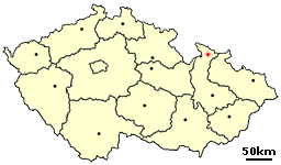
Country:
Region:
City:
Latitude and Longitude:
Time Zone:
Postal Code:
IP information under different IP Channel
ip-api
Country
Region
City
ASN
Time Zone
ISP
Blacklist
Proxy
Latitude
Longitude
Postal
Route
Luminati
Country
Region
71
City
jesenik
ASN
Time Zone
Europe/Prague
ISP
Web4Soft Internet s.r.o.
Latitude
Longitude
Postal
IPinfo
Country
Region
City
ASN
Time Zone
ISP
Blacklist
Proxy
Latitude
Longitude
Postal
Route
db-ip
Country
Region
City
ASN
Time Zone
ISP
Blacklist
Proxy
Latitude
Longitude
Postal
Route
ipdata
Country
Region
City
ASN
Time Zone
ISP
Blacklist
Proxy
Latitude
Longitude
Postal
Route
Popular places and events near this IP address

Jeseník
Town in the Czech Republic
Distance: Approx. 310 meters
Latitude and longitude: 50.22972222,17.20472222
Jeseník (Czech pronunciation: [ˈjɛsɛɲiːk]; until 1947 Frývaldov (Czech pronunciation: [ˈfriːvaldof]); German: Freiwaldau, Polish: Frywałdów) is a spa town in the Olomouc Region of the Czech Republic. It has about 11,000 inhabitants.

Lázně Jeseník
Distance: Approx. 1877 meters
Latitude and longitude: 50.24,17.18611111
Lázně Jeseník (German: Bad Gräfenberg) is a spa resort in Jeseník in the Olomouc Region of the Czech Republic. The place is known for its connection with Vincent Priessnitz, an early proponent of hydrotherapy. Priessnitz had founded the first modern hydrotherapeutic institute in the world here.

Rejvíz
Village in Olomouc, Czech Republic
Distance: Approx. 7229 meters
Latitude and longitude: 50.23,17.31
Rejvíz (Czech pronunciation: [ˈrɛjviːs]; German: Reihwiesen) is a village and administrative part of Zlaté Hory in Jeseník District in the Olomouc Region of the Czech Republic. It is a popular tourist destination.

Česká Ves
Municipality in Olomouc, Czech Republic
Distance: Approx. 3252 meters
Latitude and longitude: 50.2575,17.22805556
Česká Ves (German: Böhmischdorf) is a municipality and village in Jeseník District in the Olomouc Region of the Czech Republic. It has about 2,300 inhabitants.
Jeseník District
District in Olomouc, Czech Republic
Distance: Approx. 3647 meters
Latitude and longitude: 50.25,17.16666667
Jeseník District (Czech: okres Jeseník) is a district in the Olomouc Region of the Czech Republic. Its capital is the town of Jeseník. With approximately 37,000 inhabitants, it is the least populated district of the Czech Republic.
Lipová-lázně
Municipality in Olomouc, Czech Republic
Distance: Approx. 4853 meters
Latitude and longitude: 50.22777778,17.14055556
Lipová-lázně (until 1960 Dolní Lipová; German: Bad Lindewiese) is a spa municipality and village in Jeseník District in the Olomouc Region of the Czech Republic. It has about 2,100 inhabitants.

Černá Voda
Municipality in Olomouc, Czech Republic
Distance: Approx. 9649 meters
Latitude and longitude: 50.30833333,17.14694444
Černá Voda (German: Schwarzwasser) is a municipality and village in Jeseník District in the Olomouc Region of the Czech Republic. It has about 500 inhabitants. Černá Voda lies approximately 9 kilometres (6 mi) north of Jeseník, 80 km (50 mi) north of Olomouc, and 197 km (122 mi) east of Prague.

Hradec-Nová Ves
Municipality in Olomouc, Czech Republic
Distance: Approx. 7750 meters
Latitude and longitude: 50.2825,17.28194444
Hradec-Nová Ves (German: Gröditz-Neudorf, Polish: Grodziec-Nowa Wieś) is a municipality and village in Jeseník District in the Olomouc Region of the Czech Republic. It has about 400 inhabitants. Hradec-Nová Ves lies approximately 9 kilometres (6 mi) north-east of Jeseník, 78 km (48 mi) north of Olomouc, and 205 km (127 mi) east of Prague.

Písečná (Jeseník District)
Municipality in Olomouc, Czech Republic
Distance: Approx. 5679 meters
Latitude and longitude: 50.27305556,17.25388889
Písečná (Czech: [ˈpiːsɛtʃnaː] ; until 1948 Sandhýbl; German: Sandhübel) is a municipality and village in Jeseník District in the Olomouc Region of the Czech Republic. It has about 1,100 inhabitants.

Supíkovice
Municipality in Olomouc, Czech Republic
Distance: Approx. 8135 meters
Latitude and longitude: 50.29777778,17.25527778
Supíkovice (German: Saubsdorf) is a municipality and village in Jeseník District in the Olomouc Region of the Czech Republic. It has about 600 inhabitants.

Keprník
Mountain in the Czech Republic
Distance: Approx. 9385 meters
Latitude and longitude: 50.17083333,17.11638889
Keprník is a mountain in the Hrubý Jeseník mountain range in the Czech Republic. It has an elevation of 1,423 m (4,669 ft) above sea level. It is located in the municipality of Ostružná, on the historical border between Silesia and Moravia.

Orlík (mountain)
1,204 metre mountain in the Hrubý Jeseník range, Czech Republic
Distance: Approx. 8843 meters
Latitude and longitude: 50.17666667,17.29888889
Orlík (German: Urlichkuppe) is a mountain in the Hrubý Jeseník mountain range in the Czech Republic. It has an elevation of 1,204 m (3,950 ft) above sea level. It is located in the municipality of Zlaté Hory.
Weather in this IP's area
clear sky
3 Celsius
-1 Celsius
3 Celsius
4 Celsius
1026 hPa
86 %
1026 hPa
972 hPa
10000 meters
4.02 m/s
290 degree
10 %
07:05:15
16:06:36

