185.66.177.253 - IP Lookup: Free IP Address Lookup, Postal Code Lookup, IP Location Lookup, IP ASN, Public IP
Country:
Region:
City:
Location:
Time Zone:
Postal Code:
IP information under different IP Channel
ip-api
Country
Region
City
ASN
Time Zone
ISP
Blacklist
Proxy
Latitude
Longitude
Postal
Route
Luminati
Country
Region
sh
City
gudow
ASN
Time Zone
Europe/Berlin
ISP
CSN Solutions e.K.
Latitude
Longitude
Postal
IPinfo
Country
Region
City
ASN
Time Zone
ISP
Blacklist
Proxy
Latitude
Longitude
Postal
Route
IP2Location
185.66.177.253Country
Region
mecklenburg-vorpommern
City
gudow
Time Zone
Europe/Berlin
ISP
Language
User-Agent
Latitude
Longitude
Postal
db-ip
Country
Region
City
ASN
Time Zone
ISP
Blacklist
Proxy
Latitude
Longitude
Postal
Route
ipdata
Country
Region
City
ASN
Time Zone
ISP
Blacklist
Proxy
Latitude
Longitude
Postal
Route
Popular places and events near this IP address
Amt Neuhaus
Municipality in Lower Saxony, Germany
Distance: Approx. 5082 meters
Latitude and longitude: 53.28527778,10.93222222
Amt Neuhaus is a municipality in the District of Lüneburg, in Lower Saxony, Germany. Amt means "municipal office" in German. The original "municipal office of Neuhaus" existed since at least the 17th century until 1885, consecutively as part of Saxe-Lauenburg (which ceased to exist in 1689), Electorate of Hanover (1689-1810), Kingdom of Hanover (1814-1866), and the Prussian Province of Hanover (1866-1885).

Lübtheen
Town in Mecklenburg-Vorpommern, Germany
Distance: Approx. 5107 meters
Latitude and longitude: 53.3,11.08333333
Lübtheen (German pronunciation: [lʏpˈteːn]) is a municipality in the Ludwigslust-Parchim district, in Mecklenburg-Western Pomerania, Germany. It is situated 28 km west of Ludwigslust, and 37 km southwest of Schwerin. It is part of the Hamburg Metropolitan Region.

Pritzier
Municipality in Mecklenburg-Vorpommern, Germany
Distance: Approx. 9601 meters
Latitude and longitude: 53.36666667,11.08333333
Pritzier is a municipality in the Ludwigslust-Parchim district of Mecklenburg-Vorpommern, Germany. The Pritzier municipality consists of three villages: Pritzier, Pritzier Bahnhof, and Schwechow.

Elbhöhen-Wendland Nature Park
Distance: Approx. 8007 meters
Latitude and longitude: 53.22248056,10.98632778
The Elbhöhen-Wendland Nature Park (German: Naturpark Elbhöhen-Wendland), formerly known as the Elbufer-Drawehn Nature Park (Naturpark Elbufer-Drawehn) is a German nature park east of Lüneburg in Lower Saxony.

Rögnitz (river)
River in Germany
Distance: Approx. 4767 meters
Latitude and longitude: 53.3182,10.9491
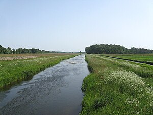
Rögnitz is a river of Mecklenburg-Vorpommern and Lower Saxony, Germany. It flows into the Sude in Sückau.

Krainke
River in Germany
Distance: Approx. 9659 meters
Latitude and longitude: 53.3354,10.8804
The Krainke is a river of Mecklenburg-Vorpommern and Lower Saxony, Germany. It flows into the Sude near Besitz.

Mecklenburg Elbe Valley Nature Park
Distance: Approx. 4827 meters
Latitude and longitude: 53.336,11.02
The Mecklenburg Elbe Valley Nature Park (German: Mecklenburgisches Elbetal) is part of the UNESCO biosphere reserve of Elbe River Landscape. At over 400 river kilometres long, the Elbe River Landscape Biosphere Reserve runs through the five German states of: Saxony-Anhalt, Brandenburg, Lower Saxony, Mecklenburg-Vorpommern and Schleswig-Holstein. It lies in the district of Ludwigslust-Parchim in Mecklenburg-Vorpommern.
Sumte, Lower Saxony, Germany
Place in Lower Saxony, Germany
Distance: Approx. 8330 meters
Latitude and longitude: 53.28333333,10.88333333
Sumte (, German pronunciation: [ˈzʊmtə]) is a village in the municipality of Amt Neuhaus, located 30 km east of the county town Lüneburg in the state of Lower Saxony in northern Germany. Sumte was part of the only exchange of territory between states of the former German Democratic Republic (East Germany) and West Germany. The location east of the river Elbe is unique for a community in Lower Saxony.
Weather in this IP's area
clear sky
-3 Celsius
-5 Celsius
-3 Celsius
-3 Celsius
1042 hPa
93 %
1042 hPa
1038 hPa
10000 meters
1.6 m/s
1.47 m/s
240 degree
5 %
