Country:
 Germany
Region:
City:
Latitude and Longitude:
Time Zone:
Postal Code:
IP information under different IP Channel
ip-api
Country
Region
City
ASN
Time Zone
ISP
Blacklist
Proxy
Latitude
Longitude
Postal
Route
Luminati
Country
DEASN
Time Zone
Europe/Berlin
ISP
PHILUNET GmbH
Latitude
Longitude
Postal
IPinfo
Country
Region
City
ASN
Time Zone
ISP
Blacklist
Proxy
Latitude
Longitude
Postal
Route
db-ip
Country
Region
City
ASN
Time Zone
ISP
Blacklist
Proxy
Latitude
Longitude
Postal
Route
ipdata
Country
Region
City
ASN
Time Zone
ISP
Blacklist
Proxy
Latitude
Longitude
Postal
Route
Popular places and events near this IP address
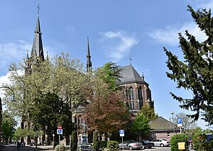
Kevelaer
Town in North Rhine-Westphalia, Germany
Distance: Approx. 1199 meters
Latitude and longitude: 51.58333333,6.25
Kevelaer (Low Rhenish: Käwela) is a town in the district of Kleve, in North Rhine-Westphalia in Germany. It is the largest Catholic pilgrimage location within north-western Europe. Over one million Marian devotees, mostly from Germany and the Netherlands, visit the Basilica of Kevelaer every year to honour the Blessed Virgin Mary.

Weeze Airport
Airport in North Rhine-Westphalia, Germany
Distance: Approx. 6678 meters
Latitude and longitude: 51.6025,6.14222222
Weeze Airport (IATA: NRN, ICAO: EDLV), less commonly known as Niederrhein Airport, is a minor international airport in the Lower Rhine region of Germany. It is used by Ryanair. The airport is situated 3.7 km (2.3 mi) southwest of the municipality of Weeze (German pronunciation: [ˈveːt͡sə]) and 7 km (4.3 mi) northwest of Kevelaer, about 33 km (21 mi) southeast of the Dutch city of Nijmegen, and 48 km (30 mi) northwest of the German city of Duisburg.

RAF Laarbruch
Former Royal Air Force station in North Rhine-Westphalia, Germany
Distance: Approx. 6678 meters
Latitude and longitude: 51.6025,6.14222222
Royal Air Force Laarbruch, more commonly known as RAF Laarbruch ICAO EDUL (from 1 January 1995 ETUL) was a Royal Air Force station, a military airfield, located in Germany on its border with the Netherlands. The Station's motto was Eine feste Burg (German for 'A Mighty Fortress'). The site now operates as the civilian Weeze Airport, in the Lower Rhine region of Germany.
Weeze
Municipality in North Rhine-Westphalia, Germany
Distance: Approx. 5586 meters
Latitude and longitude: 51.62666667,6.19666667
Weeze (German pronunciation: [ˈveːt͡sə], Dutch: Wees) is a municipality in the Lower Rhine (Niederrhein) region, located in the northwestern part of North Rhine-Westphalia, specifically in the district of Kleve and the Düsseldorf region. The municipality comprises the town of Weeze and the village of Wemb and has approximately 10,500 inhabitants. Situated in the district of Kleve, it is embedded in the northwestern part of the Lower Rhine Region, lying between Goch to the north and Kevelaer to the south.
Dondert
River in Germany
Distance: Approx. 1743 meters
Latitude and longitude: 51.5944,6.2478
Dondert is a river of North Rhine-Westphalia, Germany. It flows into the Niers near Kevelaer.

Gelderner Fleuth
River in Germany
Distance: Approx. 6760 meters
Latitude and longitude: 51.548,6.314
Gelderner Fleuth (pronounced: [fløːt]) is an approximately 27.0 km (16.8 mi) long, non-navigable, tributary of the Niers in North Rhine-Westphalia, Germany. It rises in the village of An der Gastendonk, which belongs to the city of Kempen, flows first west and then turns north east of Wachtendonk to flow into the Niers near the city of Geldern, which gives it its name. The creek designated as Gelderner Fleuth on the water station map has its source in the ditch system of the Gastendonk cultural monument in Kempen.

Issumer Fleuth
River in Germany
Distance: Approx. 3706 meters
Latitude and longitude: 51.5889,6.2852
Issumer Fleuth is a river of North Rhine-Westphalia, Germany. It flows into the Niers near Kevelaer.

Kervenheimer Mühlenfleuth
River in Germany
Distance: Approx. 6734 meters
Latitude and longitude: 51.6405,6.2093
Kervenheimer Mühlenfleuth is a river of North Rhine-Westphalia, Germany. It flows into the Niers near Weeze.

Weeze station
Railway station in Weeze, Germany
Distance: Approx. 5348 meters
Latitude and longitude: 51.62444444,6.19722222
Weeze is a railway station in the village of Weeze, North Rhine Westphalia, Germany. The station opened on 5 March 1863 on the Lower Left Rhine Railway. The train services are operated by NordWestBahn.

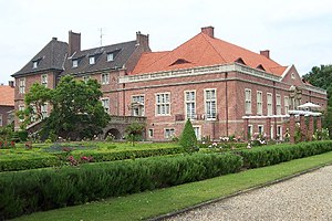
Hertefeld Castle
Distance: Approx. 5629 meters
Latitude and longitude: 51.62847222,6.20152778
The Hertefeld Castle estate, consisting of a castle ruin and attached park, stands in the town of Weeze in North Rhine-Westphalia. It was established in the fourteenth century.

Kevelaer station
Railway station in Kevelaer, Germany
Distance: Approx. 1304 meters
Latitude and longitude: 51.58111111,6.25166667
Kevelaer is a railway station in the town of Kevelaer, North Rhine Westphalia, Germany. The station opened on 5 March 1863 on the Lower Left Rhine Railway. The train services are operated by NordWestBahn.

Schloss Haag
Distance: Approx. 8002 meters
Latitude and longitude: 51.534581,6.320034
Castle Haag (German: Schloss Haag) was a moated castle in the Rhineland region of Germany. It is located in Geldern in the district of Kleve, North Rhine-Westphalia. It is owned by the Van Hoensbroeck family.
Weather in this IP's area
fog
6 Celsius
4 Celsius
4 Celsius
6 Celsius
1033 hPa
98 %
1033 hPa
1030 hPa
300 meters
2.06 m/s
330 degree
100 %
07:50:31
16:48:27