Country:
Region:
City:
Latitude and Longitude:
Time Zone:
Postal Code:
IP information under different IP Channel
ip-api
Country
Region
City
ASN
Time Zone
ISP
Blacklist
Proxy
Latitude
Longitude
Postal
Route
Luminati
Country
Region
23
City
valtournenche
ASN
Time Zone
Europe/Rome
ISP
Fiber Telecom S.p.A.
Latitude
Longitude
Postal
IPinfo
Country
Region
City
ASN
Time Zone
ISP
Blacklist
Proxy
Latitude
Longitude
Postal
Route
db-ip
Country
Region
City
ASN
Time Zone
ISP
Blacklist
Proxy
Latitude
Longitude
Postal
Route
ipdata
Country
Region
City
ASN
Time Zone
ISP
Blacklist
Proxy
Latitude
Longitude
Postal
Route
Popular places and events near this IP address

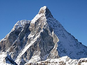
Matterhorn
Mountain in the Swiss and Italian Alps
Distance: Approx. 5166 meters
Latitude and longitude: 45.97638889,7.65861111
The Matterhorn (German: [ˈmatɐˌhɔʁn] , Swiss Standard German: [ˈmatərˌhɔrn]; Italian: Cervino [tʃerˈviːno]; French: Cervin [sɛʁvɛ̃]; Romansh: Mont(e) Cervin(u) or Matterhorn [mɐˈtɛrorn]) is a mountain of the Alps, straddling the main watershed and border between Italy and Switzerland. It is a large, near-symmetric pyramidal peak in the extended Monte Rosa area of the Pennine Alps, whose summit is 4,478 metres (14,692 ft) above sea level, making it one of the highest summits in the Alps and Europe. The four steep faces, rising above the surrounding glaciers, face the four compass points and are split by the Hörnli, Furggen, Leone/Lion, and Zmutt ridges.

Dent d'Hérens
Mountain in the Pennine Alps
Distance: Approx. 4524 meters
Latitude and longitude: 45.97005556,7.60508333
The Dent d'Hérens (4,173 m) is a mountain in the Pennine Alps, lying on the border between Italy and Switzerland. The mountain lies a few kilometres west of the Matterhorn. Notable summits along the east ridge are Punta Bianca (3917 m), the prominent Punta Carrel (3841 m) with its subpeak Punta Maquignaz, and the significant Punta Maria Cristina (3703 m).

Furgghorn
Mountain in Switzerland
Distance: Approx. 5723 meters
Latitude and longitude: 45.95416667,7.69972222
The Furgghorn (German, Italian: Cima del Breuil) is a mountain of the Pennine Alps, located on the boundary between the canton of Valais (Switzerland) and Aosta Valley (northern Italy). It lies on the range south-east of the Matterhorn, near the Theodul Pass. The closest locality is Breuil-Cervinia on the Italian side.

Pic Tyndall
Minor summit below the Matterhorn
Distance: Approx. 4893 meters
Latitude and longitude: 45.97494444,7.65438889
Pic Tyndall (from French: lit, Tyndall Peak) is a minor summit below the Matterhorn (western shoulder) in the Pennine Alps, on the boundary between Aosta Valley (northern Italy) and Switzerland. Because of its small prominence it was included in the enlarged list of alpine four-thousanders. It was named in honour of John Tyndall who made the first ascent.
Picco Muzio
Mountain in Switzerland
Distance: Approx. 5121 meters
Latitude and longitude: 45.97519444,7.66094444
Picco Muzio (French: Pic Muzio) is a minor summit below the Matterhorn on the Furggen ridge. Because of its prominence on that ridge, it was included in the 'enlarged list' of alpine four-thousanders.

Solvay Hut
Hut on the Matterhorn in Switzerland
Distance: Approx. 5544 meters
Latitude and longitude: 45.97875,7.66291667
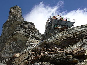
The Solvay Hut or Solvay Bivouac (German: Solvayhütte) is a mountain hut located on the north-eastern ridge (Hörnli Ridge) of the Matterhorn, near Zermatt in the canton of Valais. At 4,003 metres (13,133 ft) it is the highest mountain hut owned by the Swiss Alpine Club, but can be used only in case of emergency. The Hörnli Hut, lying 700 meters below on the same ridge, is the starting point of the normal route to the summit.

Second ascent of the Matterhorn
Made in July 1865, three days after the first
Distance: Approx. 5152 meters
Latitude and longitude: 45.97666667,7.65722222
The second ascent of the Matterhorn was accomplished in July 1865, only three days after the successful (with 4 fatalities) expedition led by Edward Whymper on the Zermatt side. The second was effected on the Italian side by Jean-Antoine Carrel and Jean-Baptiste Bich with the abbé Amé Gorret and Jean-Augustin Meynet who followed them near to the summit. The party started from Breuil on 16 July and reached the top the following day.

Refuge Jean-Antoine Carrel
Distance: Approx. 4525 meters
Latitude and longitude: 45.97305556,7.6475
Refuge Jean-Antoine Carrel is a refuge in the Alps at an altitude of 3,830m in Aosta Valley, Italy. It is located on the south-west ridge of the Matterhorn, near the Swiss border. The mountain hut was named after Jean-Antoine Carrel who made the first ascent of the Matterhorn via the south-west ridge.
Refuge Duc des Abruzzes à l'Oriondé
Distance: Approx. 2965 meters
Latitude and longitude: 45.95916667,7.64388889
Refuge Duc des Abruzzes à l'Oriondé is a refuge located above Breuil-Cervinia in the Aosta Valley. The refuge lies on the south side of the Matterhorn, at a height of 2,802 metres. It is used for the ascent of the Italian normal route.
Furggen
Mountain of the Pennine Alps
Distance: Approx. 4618 meters
Latitude and longitude: 45.95694444,7.68138889
The Furggen (3,492 m) is a mountain of the Pennine Alps, located on the border between Italy (Aosta Valley) and Switzerland (Valais). It is the culminating point of the ridge named Furgggrat stretching from the Furggjoch (3,271 m) to the Theodul Pass (3,295 m), and is located halfway between the Matterhorn and Testa Grigia. The peak is the site of the now abandoned cable car station.
Punta Maria Cristina
Mountain in Switzerland
Distance: Approx. 4358 meters
Latitude and longitude: 45.97222222,7.62027778
The Punta Maria Cristina (lit. 'Maria Cristina Peak') is a mountain (3,706 m) of the Pennine Alps, located on the Swiss-Italian border. It lies on the main Alpine watershed, between the Dent d'Hérens and the Matterhorn. On the summit is the permanent bivouac shelter named Giorgio e Renzo Novella, dedicated in 1983 to the Novella Brothers from Vercelli, who both died while mountain-climbing.
Testa del Leone
Mountain in Switzerland
Distance: Approx. 4238 meters
Latitude and longitude: 45.97111111,7.64333333
The Testa del Leone (3,715 m; Italian, lit. "lion head") is a mountain of the Pennine Alps, located on the border between Switzerland and Italy. It lies on the main Alpine watershed, west of the Matterhorn.
Weather in this IP's area
overcast clouds
-4 Celsius
-8 Celsius
-4 Celsius
-3 Celsius
1018 hPa
85 %
1018 hPa
792 hPa
10000 meters
3.21 m/s
3.31 m/s
322 degree
93 %
07:33:00
16:56:16


