185.6.39.209 - IP Lookup: Free IP Address Lookup, Postal Code Lookup, IP Location Lookup, IP ASN, Public IP
Country:
Region:
City:
Location:
Time Zone:
Postal Code:
ISP:
ASN:
language:
User-Agent:
Proxy IP:
Blacklist:
IP information under different IP Channel
ip-api
Country
Region
City
ASN
Time Zone
ISP
Blacklist
Proxy
Latitude
Longitude
Postal
Route
db-ip
Country
Region
City
ASN
Time Zone
ISP
Blacklist
Proxy
Latitude
Longitude
Postal
Route
IPinfo
Country
Region
City
ASN
Time Zone
ISP
Blacklist
Proxy
Latitude
Longitude
Postal
Route
IP2Location
185.6.39.209Country
Region
cork
City
cork
Time Zone
Europe/Dublin
ISP
Language
User-Agent
Latitude
Longitude
Postal
ipdata
Country
Region
City
ASN
Time Zone
ISP
Blacklist
Proxy
Latitude
Longitude
Postal
Route
Popular places and events near this IP address

Cork College of Commerce
College in Cork, Ireland
Distance: Approx. 258 meters
Latitude and longitude: 51.8957,-8.4694
Cork College of Commerce is a college that was established in December 1908 in Cork, Ireland. It was originally named the "School of Commerce and Domestic Science".

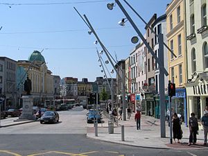
St Patrick's Street
One of the main streets of Cork, Ireland
Distance: Approx. 137 meters
Latitude and longitude: 51.89861111,-8.47222222
St Patrick's Street (Irish: Sráid Naomh Pádraig) is the main shopping street of the city of Cork in the south of Ireland. The street was subject to redevelopment in 2004, and has since won two awards as Ireland's best shopping street. St Patrick's Street is colloquially known to most locals as simply 'Patrick's Street', with the 'St' honorific dropped, in accordance with the pattern applied to many locations named after saints.

Cork (city)
City in County Cork, Munster, Ireland
Distance: Approx. 86 meters
Latitude and longitude: 51.89722222,-8.47
Cork (Irish: Corcaigh [ˈkɔɾˠkəɟ]; from corcach, meaning 'marsh') is the second largest city in Ireland, the county town of County Cork, the largest city in the province of Munster and third largest on the island of Ireland. At the 2022 census, it had a population of 224,004. The city centre is an island between two channels of the River Lee which meet downstream at its eastern end, where the quays and docks along the river lead outwards towards Lough Mahon and Cork Harbour, one of the largest natural harbours in the world.

English Market
Historic market in Cork city, Ireland
Distance: Approx. 234 meters
Latitude and longitude: 51.898,-8.474
The English Market (Irish: An Margadh Sasanach) is a municipal food market in the center of Cork city, Ireland. It stretches from Princes Street to the Grand Parade, and combines Princes Street Market and Grand Parade Market. The market is regarded for both its mid-19th century architecture and locally produced artisan food.

Oliver Plunkett Street
Street in central Cork, Ireland
Distance: Approx. 13 meters
Latitude and longitude: 51.898,-8.4705
Oliver Plunkett Street (Irish: Sráid Olibhéir Pluincéid) is a shopping street in Cork, Ireland. It was originally laid-out in the early 18th century as the city expanded eastwards beyond the original city walls.

South Mall, Cork
Distance: Approx. 108 meters
Latitude and longitude: 51.8971,-8.4697
South Mall (Irish: An Meall Theas) is one of the main streets of Cork city, Ireland. It runs from Grand Parade in the west to Parnell Place in the east. Like Grand Parade and St.
Munster Basin
Distance: Approx. 219 meters
Latitude and longitude: 51.8998,-8.469772
The Munster Basin is a late Middle to Upper Devonian age extensional (rift) sedimentary basin in the south-west of Ireland. The basin fill comprises fluvial Old Red Sandstone (ORS) magnafacies with minor silicic volcanic and mafic sub-volcanic centres. The depocentre of the basin is located between the MacGillycuddy's Reeks and the Kenmare River on the Iveragh peninsula where the succession is at least ca.

Holy Trinity Church, Cork
Church in Cork, Republic of Ireland
Distance: Approx. 262 meters
Latitude and longitude: 51.895553,-8.4708917
Holy Trinity Church, also known as Father Mathew Memorial Church, is a Roman Catholic Gothic Revival church and friary on Fr. Mathew Quay, on the bank of the River Lee in Cork. It belongs to the Order of Friars Minor Capuchin and is the only church dedicated to Father Theobald Mathew.

Parnell Place
Street in Cork, Ireland
Distance: Approx. 239 meters
Latitude and longitude: 51.898634,-8.467336
Parnell Place (Irish: Plás Parnell) is a street in Cork, Ireland. It is a major south-to-north route across the city centre, and the location of Parnell Place Bus Station. In the south, it starts at the junction with South Mall, Lapp's Quay and Parnell Bridge, running to Merchant's Quay in the north.

Huguenot Cemetery, Cork
Cemetery in Cork, Ireland
Distance: Approx. 231 meters
Latitude and longitude: 51.89874,-8.47368
Huguenot Cemetery was created between 1710 and 1733 as a cemetery for the Huguenot inhabitants in the city of Cork. It is believed to be one of the last two surviving Huguenot graveyards in western Europe.

Theatre Royal, Cork
Distance: Approx. 13 meters
Latitude and longitude: 51.8978,-8.4705
The Theatre Royal was a patent theatre located in Cork City, Ireland.

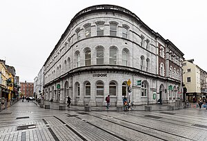
Cork General Post Office
Cork's General Post Office
Distance: Approx. 16 meters
Latitude and longitude: 51.89791,-8.47037
Cork General Post Office (GPO) is a historic post office building in Oliver Plunkett Street in Cork, Ireland. Built on the site of an older theatre, it is one of the few An Post offices in Ireland which still retains the General Post Office moniker from the times when the Irish postal service was under the governance of the British General Post Office. The post office is one of Oliver Plunkett Street's most prominent buildings, and is listed as a protected structure.
Weather in this IP's area
broken clouds
9 Celsius
5 Celsius
9 Celsius
9 Celsius
971 hPa
93 %
971 hPa
959 hPa
5000 meters
7.2 m/s
12.35 m/s
180 degree
75 %