185.59.62.181 - IP Lookup: Free IP Address Lookup, Postal Code Lookup, IP Location Lookup, IP ASN, Public IP
Country:
Region:
City:
Location:
Time Zone:
Postal Code:
IP information under different IP Channel
ip-api
Country
Region
City
ASN
Time Zone
ISP
Blacklist
Proxy
Latitude
Longitude
Postal
Route
Luminati
Country
ASN
Time Zone
Europe/London
ISP
Pulsant (Scotland) Ltd
Latitude
Longitude
Postal
IPinfo
Country
Region
City
ASN
Time Zone
ISP
Blacklist
Proxy
Latitude
Longitude
Postal
Route
IP2Location
185.59.62.181Country
Region
england
City
york
Time Zone
Europe/London
ISP
Language
User-Agent
Latitude
Longitude
Postal
db-ip
Country
Region
City
ASN
Time Zone
ISP
Blacklist
Proxy
Latitude
Longitude
Postal
Route
ipdata
Country
Region
City
ASN
Time Zone
ISP
Blacklist
Proxy
Latitude
Longitude
Postal
Route
Popular places and events near this IP address

Siege of York
Siege of the English Civil War (1644)
Distance: Approx. 64 meters
Latitude and longitude: 53.958,-1.082
The siege of York in 1644 was a prolonged contest for York during the First English Civil War, between the Scottish Covenanter army and the Parliamentarian armies of the Northern Association and Eastern Association, and the Royalist Army under the Marquess of Newcastle. It lasted from 22 April until 1 July when the city was relieved by Prince Rupert of the Rhine. Rupert and Newcastle were defeated the next day at the decisive Battle of Marston Moor, and the siege resumed until the city was surrendered on easy terms on 16 July.

York Central (UK Parliament constituency)
Parliamentary constituency in the United Kingdom
Distance: Approx. 81 meters
Latitude and longitude: 53.957,-1.082
York Central is a parliamentary constituency which is represented in the House of Commons of the UK Parliament by Rachael Maskell of the Labour Party and the Co-operative Party.
York Rural Sanitary District
Distance: Approx. 64 meters
Latitude and longitude: 53.958,-1.082
York was a rural sanitary district in Yorkshire, England, until 1894. It was based on the York poor law union (minus the City of York itself, which was an urban sanitary district), and included parishes in the West Riding, the North Riding and the East Riding, forming a ring around the city. It was abolished in 1894 under the Local Government Act 1894, and split to form rural districts.
Medieval parish churches of York
Distance: Approx. 64 meters
Latitude and longitude: 53.958,-1.082
York had around 45 parish churches in 1300. Twenty survive, in whole or in part, a number surpassed in England only by Norwich, and 12 are used for worship. This article consists of a list of medieval churches which still exist in whole or in part, and a list of medieval churches which are known to have existed in the past but have been completely demolished.

Snickelways of York
Small streets and footpaths in York, England
Distance: Approx. 64 meters
Latitude and longitude: 53.958,-1.082
The Snickelways of York, often misspelt Snickleways, are a collection of narrow streets and alleys in the city of York, England. The word Snickelway was coined by local author Mark W. Jones in 1983 in his book A Walk Around the Snickelways of York, and is a portmanteau of the words snicket, meaning a passageway between walls or fences, ginnel, a narrow passageway between or through buildings, and alleyway, a narrow street or lane. Although the word is a neologism, it quickly became part of the local vocabulary, and has even been used in official council documents, for example when giving notice of temporary footpath closures.

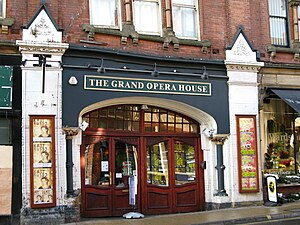
Grand Opera House, York
Theatre in York, North Yorkshire, England
Distance: Approx. 67 meters
Latitude and longitude: 53.95726,-1.08186
The Grand Opera House is a theatre on the corner of Clifford Street and Cumberland Street in York, North Yorkshire, England. The structure, which hosts touring productions of plays, musicals, opera and ballet, as well as one-off performances by comedians, and other theatrical and musical events, is a Grade II listed building.

St Michael's Church, Spurriergate, York
Grade I listed church in York, England
Distance: Approx. 24 meters
Latitude and longitude: 53.95780556,-1.08261111
St Michael's Church is a Grade I listed former parish church in the Church of England, on Spurriergate in York.

Spurriergate
Street in York, England
Distance: Approx. 67 meters
Latitude and longitude: 53.9582,-1.0827
Spurriergate is a short street in the city centre of York, in England.

Ousegate
Street in York, England
Distance: Approx. 52 meters
Latitude and longitude: 53.9579,-1.0821
Ousegate is a street in the city centre of York, in England. It is divided into High Ousegate and Low Ousegate. The street forms part of the city's central shopping area.

Cumberland House, York
Grade I listed building in York, England
Distance: Approx. 81 meters
Latitude and longitude: 53.95687,-1.08278
Cumberland House is a Grade I listed building in the city centre of York, in England. The house lies on King's Staith, overlooking the River Ouse. While the basement is accessed from King's Staith, because the street frequently floods, the house's main entrance is on Cumberland Street.

The Water Lanes
Three medieval streets in York, England
Distance: Approx. 74 meters
Latitude and longitude: 53.957,-1.0822
The Water Lanes were three medieval streets in the city of York in the north of England. They led from Castlegate road down to the waterfront of the River Ouse. The Lanes were similar in appearance to the Shambles with the jettied buildings hanging over the street.

Kings Arms, York
Grade II listed pub in York, England
Distance: Approx. 62 meters
Latitude and longitude: 53.9571,-1.0831
The Kings Arms is a pub lying by the River Ouse in the city centre of York, in England. The building lies across King's Staith from the River Ouse, on its corner with King Street. The building is the only surviving building to form part of First Water Lane, a medieval street that was demolished in a slum clearance program in 1852 and was rebuilt as King Street.
Weather in this IP's area
overcast clouds
6 Celsius
3 Celsius
6 Celsius
6 Celsius
1016 hPa
87 %
1016 hPa
1015 hPa
10000 meters
4.31 m/s
9.4 m/s
224 degree
100 %