Country:
 Poland
Region:
City:
Latitude and Longitude:
Time Zone:
Postal Code:
IP information under different IP Channel
ip-api
Country
Region
City
ASN
Time Zone
ISP
Blacklist
Proxy
Latitude
Longitude
Postal
Route
IPinfo
Country
Region
City
ASN
Time Zone
ISP
Blacklist
Proxy
Latitude
Longitude
Postal
Route
MaxMind
Country
Region
City
ASN
Time Zone
ISP
Blacklist
Proxy
Latitude
Longitude
Postal
Route
Luminati
Country
PLRegion
24
City
zabrze
ASN
Time Zone
Europe/Warsaw
ISP
Miasto Zabrze
Latitude
Longitude
Postal
db-ip
Country
Region
City
ASN
Time Zone
ISP
Blacklist
Proxy
Latitude
Longitude
Postal
Route
ipdata
Country
Region
City
ASN
Time Zone
ISP
Blacklist
Proxy
Latitude
Longitude
Postal
Route
Popular places and events near this IP address

Zabrze
City in Silesian Voivodeship, Poland
Distance: Approx. 471 meters
Latitude and longitude: 50.3025,18.77805556
Zabrze (Polish pronunciation: [ˈzabʐɛ] ; German: 1915–1945: Hindenburg O.S., full form: Hindenburg in Oberschlesien, Silesian: Zŏbrze, Yiddish: זאַבזשע, romanized: Zabzhe) is an industrial city in Silesia in southern Poland, near Katowice. It lies in the western part of the Metropolis GZM, a metropolis with a population of around 2 million. It is in the Silesian Highlands, on the Bytomka River, a tributary of the Oder.
Górnik Zabrze
Association football club in Zabrze, Poland
Distance: Approx. 1264 meters
Latitude and longitude: 50.29638889,18.76861111
Górnik Zabrze Spółka Akcyjna, commonly referred to as Górnik Zabrze S.A. or simply Górnik Zabrze (Polish pronunciation: [ˈɡurɲiɡ ˈzabʐɛ]), is a Polish football club from Zabrze. Górnik is one of the most successful Polish football clubs in history, winning the second-most Polish Championship titles together with Ruch Chorzów. The club was a dominant force in the 1960s and 1980s.
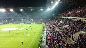
Arena Zabrze
Football stadium in Zabrze, Poland
Distance: Approx. 1273 meters
Latitude and longitude: 50.29631667,18.76856389
The Arena Zabrze, officially known as the Stadion im. Ernesta Pohla w Zabrzu (Ernest Pohl Stadium in Zabrze), is a football stadium in Zabrze, Poland. It is the home ground of Górnik Zabrze.

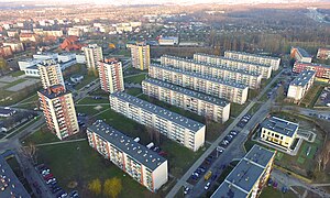
Makoszowy
District of Zabrze in Silesian Voivodeship, Poland
Distance: Approx. 4045 meters
Latitude and longitude: 50.270261,18.775877
Makoszowy (Zabrze-Makoszowy, German: Makoschau) is a district of Zabrze, Silesian Voivodeship, Poland, located in the southern part of the city. Makoszowy is located on the Kłodnica river with its two tributaries, Bielczanka and Czarnawka, surrounded with forests and ponds. Anglers like to fish here or just come and have a rest.

Drogowa Trasa Średnicowa
Controlled-access dual-carriageway in Silesia, Poland
Distance: Approx. 5230 meters
Latitude and longitude: 50.298611,18.848889
Drogowa Trasa Średnicowa (DTŚ, can be translated as diametral highway or central highway) is a controlled-access highway in Silesian Voivodeship, Poland. The DTŚ is entirely a dual carriageway with a minimum of 3 lanes in each direction. It is one of the most important roads of the Upper Silesian Industrial Region.
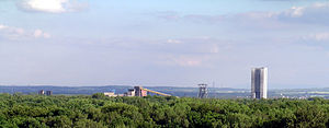
Sośnica-Makoszowy Coal Mine
Mine in Gliwice, Zabrze, Silesian Voivodeship, Poland
Distance: Approx. 3713 meters
Latitude and longitude: 50.2733,18.7735
The Sośnica-Makoszowy coal mine is a large mine in the south of Poland near Gliwice and Zabrze, Silesian Voivodeship, 267 km south-west of the capital, Warsaw. Sośnica-Makoszowy represents one of the largest coal reserves in Poland, having estimated reserves of 180 million tonnes of coal. The annual coal production is around 4.27 million tonnes.

Ruda Śląska railway station
Railway station in Poland
Distance: Approx. 5371 meters
Latitude and longitude: 50.31583333,18.85055556
Ruda Śląska railway station is a railway station in Ruda Śląska, Poland. As of 2012, it is served by Koleje Śląskie on the Gliwice–Częstochowa route, calling at Katowice and Zawiercie.

Culture and Recreation Park in Gliwice
Communal forest in Gliwice, Poland
Distance: Approx. 4643 meters
Latitude and longitude: 50.3075,18.71111111
Culture and Recreation Park (Polish: Park Kultury i Wypoczynku or Las Żorek, German: Stadtwald) is a communal forest in Gliwice. Inside the park is located castle forest (Polish: Zameczek Leśny).

St Joseph's Church, Zabrze
Distance: Approx. 1322 meters
Latitude and longitude: 50.29517,18.771353
St. Joseph's Church (Polish: Kościół Świętego Józefa, German: Josefskirche) in Zabrze is a Roman Catholic church built from 1930-1931 in the Expressionist style. It is one of several Brick Expressionist buildings designed by Dominikus Böhm (1880–1955).

Guido Mine and Coal Mining Museum
Historic mine and museum in Zabrze, Poland
Distance: Approx. 2040 meters
Latitude and longitude: 50.2896,18.7871
The Guido mine (Polish: Zabytkowa Kopalnia Węgla Kamiennego) is a historic deep coal mine and museum in Zabrze, Silesia, Poland. The museum is an Anchor point on the European Route of Industrial Heritage. This is an object of cultural heritage inscribed in the registry of the Silesian Voivodeship (A/1342/87 z 1987-02-26) and a cultural monument in Poland (ID 641754).

Ruda, Ruda Śląska
Ruda Śląska District in Silesian Voivodeship, Poland
Distance: Approx. 5361 meters
Latitude and longitude: 50.31166667,18.85138889
Ruda (German: Ruda) is a district in the north-west of Ruda Śląska, Silesian Voivodeship, southern Poland. It has an area of 11.9 km2 and in 2006 it was inhabited by 23,134 people.
Sośnica, Gliwice
District of the city of Gliwice, Poland
Distance: Approx. 4282 meters
Latitude and longitude: 50.28027778,18.7325
Sośnica is a district of Gliwice, Poland, located in the eastern part of the city. It is bordered by the districts of Wincentów in the north, Wólka Klwatecka in the west, Młynek Janiszewski, Jóżefów, Mleczna and Huta Józefowska in the south and Krzewień in the east.
Weather in this IP's area
clear sky
17 Celsius
17 Celsius
15 Celsius
18 Celsius
1025 hPa
80 %
1025 hPa
997 hPa
10000 meters
1.34 m/s
4.02 m/s
83 degree
2 %
06:24:01
18:54:47