185.58.183.152 - IP Lookup: Free IP Address Lookup, Postal Code Lookup, IP Location Lookup, IP ASN, Public IP
Country:
Region:
City:
Location:
Time Zone:
Postal Code:
IP information under different IP Channel
ip-api
Country
Region
City
ASN
Time Zone
ISP
Blacklist
Proxy
Latitude
Longitude
Postal
Route
Luminati
Country
Region
111
City
lokev
ASN
Time Zone
Europe/Ljubljana
ISP
Telekom Slovenije, d.d.
Latitude
Longitude
Postal
IPinfo
Country
Region
City
ASN
Time Zone
ISP
Blacklist
Proxy
Latitude
Longitude
Postal
Route
IP2Location
185.58.183.152Country
Region
izola
City
izola
Time Zone
Europe/Ljubljana
ISP
Language
User-Agent
Latitude
Longitude
Postal
db-ip
Country
Region
City
ASN
Time Zone
ISP
Blacklist
Proxy
Latitude
Longitude
Postal
Route
ipdata
Country
Region
City
ASN
Time Zone
ISP
Blacklist
Proxy
Latitude
Longitude
Postal
Route
Popular places and events near this IP address

Izola
Town in Littoral, Slovenia
Distance: Approx. 515 meters
Latitude and longitude: 45.53444444,13.6675
Izola (Slovene pronunciation: [ˈíːzɔla] ; Italian: Isola [ˈiːzola]) is a town in southwestern Slovenia on the Adriatic coast of the Littoral traditional region. It is the seat of the Municipality of Izola and is one of the three major towns of Slovenian Istria.

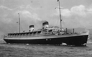
SS Rex
Italian ocean liner
Distance: Approx. 2696 meters
Latitude and longitude: 45.54888889,13.69194444
SS Rex was an Italian ocean liner launched in 1931. She held the westbound Blue Riband between 1933 and 1935, for a passenger liner in regular service crossing the Atlantic Ocean with the record highest average speed. Originally built for the Navigazione Generale Italiana (NGI) as SS Guglielmo Marconi, its state-ordered merger with the Lloyd Sabaudo line meant that the ship sailed for the newly created Italia Flotta Riunite (Italian Line).
Gažon
Place in Littoral, Slovenia
Distance: Approx. 3738 meters
Latitude and longitude: 45.5159,13.69929444
Gažon (pronounced [ɡaˈʒoːn]; Italian: Gasòn) is a village in the City Municipality of Koper in the Littoral region of Slovenia. The local church is dedicated to the Feast of Saints Peter and Paul and belongs to the Parish of Šmarje.
Ambasada Gavioli
Distance: Approx. 548 meters
Latitude and longitude: 45.53495833,13.66835556
Ambasada Gavioli was a nightclub in Izola, Slovenia named after its architect Gianni Gavioli. It had a floor space of 1,600 m2 and a capacity of 2,500 guests.

Haliaetum
Distance: Approx. 1229 meters
Latitude and longitude: 45.53350278,13.64689722
Haliaetum was a Roman port that stood in the area of Simon Bay, next to the modern village of Jagodje, on the northern Adriatic coast of the Istrian peninsula. Remains visible at extreme low tide include parts of its pier as well as various port buildings. Some excavations have been carried out in recent years, with more excavations planned in the future.
Marina Izola
A town in Izola
Distance: Approx. 1009 meters
Latitude and longitude: 45.53333333,13.65
The Marina Izola lies in the Slovenian town of Izola. The marina has berths for about 620 boats with a length of up to 30 m and a depth of 4.5 m. In addition, there is also a holiday resort with a hotel and many different attractions such as tennis courts, swimming pool and casino.
Baredi
Place in Littoral, Slovenia
Distance: Approx. 2377 meters
Latitude and longitude: 45.51768333,13.675175
Baredi (pronounced [baˈɾeːdi]; Italian: Barè) is a settlement in the Municipality of Izola in the Littoral region of Slovenia.

Dobrava, Izola
Place in Littoral, Slovenia
Distance: Approx. 2389 meters
Latitude and longitude: 45.53121944,13.63235278
Dobrava (pronounced [dɔˈbɾaːʋa]; Italian: Dobrava presso Isola) is a settlement on the Adriatic coast in the Municipality of Izola in the Littoral region of Slovenia. The Belvedere tourist resort and camping are nearby.

Jagodje
Place in Littoral, Slovenia
Distance: Approx. 1501 meters
Latitude and longitude: 45.52824444,13.64714722
Jagodje (pronounced [ˈjaːɡɔdjɛ]; Italian: Valleggia) is a settlement on the Adriatic coast in the Municipality of Izola in the Littoral region of Slovenia. It is an urbanized settlement directly southwest of the town of Izola and was created from dispersed farmsteads in the area known as Jagodje and the hamlets of Kane (Canne), Kanola (Cànola), Kažanova (Casanova), Kostrlag (Costerlago), Lavore (Lavoré), Liminjan (Limignano), Loret (Loreto), Montekalvo (Montecalvo), and Šalet (Saletto). The local church is dedicated to the Holy Mother of Loreto.

Šared
Place in Littoral, Slovenia
Distance: Approx. 2618 meters
Latitude and longitude: 45.51435833,13.65234444
Šared (pronounced [ʃaˈɾeːt]; Italian: Saredo, formerly San Giacomo) is a village in the Municipality of Izola in Slovene Istria and the Littoral region of Slovenia.

Izola City Stadium
Distance: Approx. 263 meters
Latitude and longitude: 45.53694444,13.66527778
Izola City Stadium (Slovene: Mestni stadion Izola) is a multi-use stadium in Izola, Slovenia. It is currently used mostly for football matches and is the home ground of MNK Izola. The stadium has a capacity of 5,085 seats.

Municipality of Izola
Municipality of Slovenia
Distance: Approx. 2436 meters
Latitude and longitude: 45.51666667,13.65
The Municipality of Izola (Slovene pronunciation: [ˈiːzɔla] ; Slovene: Občina Izola, Italian: Comune di Isola) is a municipality in the traditional region of the Littoral in southwestern Slovenia. The seat of the municipality is the town of Izola. Izola became a municipality in 1994.
Weather in this IP's area
clear sky
6 Celsius
4 Celsius
5 Celsius
6 Celsius
1027 hPa
44 %
1027 hPa
1013 hPa
10000 meters
2.57 m/s
70 degree