Country:
Region:
City:
Latitude and Longitude:
Time Zone:
Postal Code:
IP information under different IP Channel
ip-api
Country
Region
City
ASN
Time Zone
ISP
Blacklist
Proxy
Latitude
Longitude
Postal
Route
Luminati
Country
Region
eng
City
leicester
ASN
Time Zone
Europe/London
ISP
Syscomm Limited
Latitude
Longitude
Postal
IPinfo
Country
Region
City
ASN
Time Zone
ISP
Blacklist
Proxy
Latitude
Longitude
Postal
Route
db-ip
Country
Region
City
ASN
Time Zone
ISP
Blacklist
Proxy
Latitude
Longitude
Postal
Route
ipdata
Country
Region
City
ASN
Time Zone
ISP
Blacklist
Proxy
Latitude
Longitude
Postal
Route
Popular places and events near this IP address

Smethwick
Town in West Midlands, England
Distance: Approx. 568 meters
Latitude and longitude: 52.49305556,-1.96861111
Smethwick () is an industrial town in the Sandwell district, in the county of the West Midlands, England. It lies 4 miles (6 km) west of Birmingham city centre. Historically it was in Staffordshire and then Worcestershire before being placed into West Midlands county.

Smethwick Rolfe Street railway station
Railway station in Smethwick, England
Distance: Approx. 338 meters
Latitude and longitude: 52.496,-1.971
Smethwick Rolfe Street is one of two railway stations serving the town of Smethwick, West Midlands, England. It is situated on the Rugby–Birmingham–Stafford line 3¼ miles (5 km) north west of Birmingham New Street. The station, and all trains serving it, are operated by West Midlands Railway.
Galton Junction
Distance: Approx. 733 meters
Latitude and longitude: 52.5003,-1.9776
Galton Junction is a minor junction on the United Kingdom's West Coast Main Line's Rugby-Birmingham-Stafford Line. With Smethwick Junction, it allows northbound trains from the RBS to join the Birmingham to Worcester via Kidderminster Line in a westbound direction and vice versa. Until the re-opening of Birmingham Snow Hill for stations to Kidderminster, in 1995, all passenger services routed via Galton and Smethwick Junctions to reach Birmingham New Street.

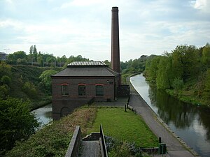
Engine Arm Aqueduct
Bridge in Smethwick
Distance: Approx. 65 meters
Latitude and longitude: 52.4979,-1.9665
The Engine Arm Aqueduct near Smethwick, West Midlands, England, was built in 1825 by Thomas Telford to carry a water feeder, the Engine Arm, from Edgbaston Reservoir over the BCN New Main Line canal to the adjacent and parallel Old Main Line. The structure is maintained by the Canal & River Trust. It is a Scheduled Ancient Monument and is Grade II* listed.
Soho railway station
Former railway station in England
Distance: Approx. 736 meters
Latitude and longitude: 52.4964,-1.9569
Soho railway station was a railway station in England, built by the London and North Western Railway on their Stour Valley Line in 1853. It served Soho in the eastern part of Smethwick, and included goods sheds and sidings. The station was rebuilt on a new site to the west of Soho Street during the 1880s.

Smethwick Junction (canal)
Canal junction in the West Midlands, England
Distance: Approx. 595 meters
Latitude and longitude: 52.4988,-1.9587
Smethwick Junction (grid reference SP028890) is the name of the canal junctions where the Birmingham Canal Navigations Main Line Canal from Birmingham splits into the BCN Old Main Line and the BCN New Main Line near to Smethwick, West Midlands, England.

Guru Nanak Gurdwara Smethwick
Distance: Approx. 373 meters
Latitude and longitude: 52.4958,-1.9714
Guru Nanak Gurdwara Smethwick (ਗੁਰੂ ਨਾਨਕ ਗੁਰਦੁਆਰਾ ਸਮੈਦਿਕ) is a Sikh gurdwara in Smethwick, in Sandwell, near Birmingham in the West Midlands of England.

Galton Valley Canal Heritage Centre
Canal museum in Smethwick, England
Distance: Approx. 339 meters
Latitude and longitude: 52.4987,-1.9723
Galton Valley Canal Museum is a small museum, located in Smethwick, England, on the border with Birmingham and alongside the BCN Main Line canals. The Museum tells the story of the development of the Galton Valley canals and those who designed, built and worked on them. In 2009 it won the Silver award in the 'Best Small Visitor Attraction' at the Black Country Tourism Awards.

2013 Smethwick fire
Distance: Approx. 586 meters
Latitude and longitude: 52.50322,-1.96942
At around 11pm on the night of 30 June 2013, a sky lantern landed on a Jayplas plastics and paper recycling plant on Dartmouth Road, near to the West Bromwich Albion football ground, at Smethwick, West Midlands, England, igniting the material stored there. The resulting fire was the largest ever dealt with by the West Midlands Fire Service (WMFS), who deployed over 200 firefighters and nearly 40 appliances, including seven appliances borrowed from Staffordshire Fire and Rescue Service and three from Hereford and Worcester Fire and Rescue Service. Three firefighters were taken to hospital.

Lions of the Great War
War memorial in Smethwick, Sandwell, England
Distance: Approx. 331 meters
Latitude and longitude: 52.49583333,-1.97055556
The Lions of the Great War is a war memorial in Smethwick, in Sandwell in the West Midlands of England, dedicated to the memory of the Sikh soldiers from the British Indian Army who fought in the First World War. It was unveiled on 4 November 2018 as part of the centenary of the end of the war. The bronze sculpture is a 10 ft (3 metres) high depiction of a Sikh soldier of the First World War on a 5 ft granite plinth; it was created by Luke Perry.

Smethwick Council House
Municipal building in Smethwick, West Midlands, England
Distance: Approx. 802 meters
Latitude and longitude: 52.4909,-1.9674
Smethwick Council House is a municipal building in Smethwick, West Midlands, England. The building, which is located on High Street and was once the headquarters of Smethwick Borough Council, is now a Grade II listed building.

Holy Trinity Church, Smethwick
Church in West Midlands, United Kingdom
Distance: Approx. 455 meters
Latitude and longitude: 52.49478694,-1.97133806
Holy Trinity Church is an Anglican church in Smethwick, West Midlands, England, and in the Diocese of Birmingham. The building is Grade II listed. The church dates originally from 1837, and was rebuilt on a larger scale in 1889.
Weather in this IP's area
overcast clouds
7 Celsius
6 Celsius
7 Celsius
8 Celsius
1026 hPa
91 %
1026 hPa
1008 hPa
8000 meters
2.57 m/s
120 degree
100 %
07:17:32
16:25:48