185.57.182.0 - IP Lookup: Free IP Address Lookup, Postal Code Lookup, IP Location Lookup, IP ASN, Public IP
Country:
Region:
City:
Location:
Time Zone:
Postal Code:
ISP:
ASN:
language:
User-Agent:
Proxy IP:
Blacklist:
IP information under different IP Channel
ip-api
Country
Region
City
ASN
Time Zone
ISP
Blacklist
Proxy
Latitude
Longitude
Postal
Route
db-ip
Country
Region
City
ASN
Time Zone
ISP
Blacklist
Proxy
Latitude
Longitude
Postal
Route
IPinfo
Country
Region
City
ASN
Time Zone
ISP
Blacklist
Proxy
Latitude
Longitude
Postal
Route
IP2Location
185.57.182.0Country
Region
satakunta
City
rauma
Time Zone
Europe/Helsinki
ISP
Language
User-Agent
Latitude
Longitude
Postal
ipdata
Country
Region
City
ASN
Time Zone
ISP
Blacklist
Proxy
Latitude
Longitude
Postal
Route
Popular places and events near this IP address

Rauma, Finland
Town in Satakunta, Finland
Distance: Approx. 927 meters
Latitude and longitude: 61.13333333,21.5
Rauma (Finnish: [ˈrɑu̯mɑ]; Swedish: Raumo) is a town in Finland, on the western coast of the country. Rauma is in the Satakunta region, by the Gulf of Bothnia. The population of Rauma is approximately 39,000, while the sub-region has a population of approximately 65,000.
Rauman maalaiskunta
Distance: Approx. 3698 meters
Latitude and longitude: 61.1314,21.5794
Rauman maalaiskunta (the rural municipality of Rauma, often abbreviated Rauman mlk) is a former municipality of Finland. It was annexed to Rauma on 1 January 1993. The population of the municipality at the time of annexation was about 9,000.

Äijänsuo Ice Hall
Arena in Rauma, Finland
Distance: Approx. 840 meters
Latitude and longitude: 61.12055556,21.50305556
Äijänsuo Ice Hall is an arena in Rauma, Finland. It is primarily used for ice hockey, and is the home arena of Lukko. It opened in 1970 and holds 5,400 people.
Tarvonsaari
Neighbourhood in Rauma sub-region, Satakunta, Finland
Distance: Approx. 614 meters
Latitude and longitude: 61.12861111,21.50027778
Tarvonsaari is a neighbourhood of Rauma, Finland. It is located in the centre of the city.
Merirauma
Neighbourhood in Rauma sub-region, Satakunta, Finland
Distance: Approx. 3350 meters
Latitude and longitude: 61.14805556,21.46666667
Merirauma is a neighbourhood of Rauma, Finland. It is located in the northeast of the city and features several islands offshore including Kuuskari, Polla and Kaskinen.

Rauma Maritime Museum
Museum in Rauma, Finland
Distance: Approx. 927 meters
Latitude and longitude: 61.13333333,21.5
Rauma Maritime Museum (Finnish: Rauman merimuseo) is a museum in Rauma, Finland held by Rauma Maritime Museum Foundation. The museum opened in the former Maritime School in 2004.
Raumanmeri school shooting
1989 school shooting in Rauma, Finland
Distance: Approx. 1056 meters
Latitude and longitude: 61.1309,21.4933
The Raumanmeri school shooting was a school shooting that occurred on 25 January 1989 at the Raumanmeri secondary school in Rauma, Finland. It was the first school shooting in the history of Finland. Tero Toivola, a 14 year old student at the Raumanmeri secondary school fatally shot two of his classmates using a pistol that belonged to his father.

Church of the Holy Cross, Rauma
Building in Rauma, Finland
Distance: Approx. 308 meters
Latitude and longitude: 61.12972222,21.51222222
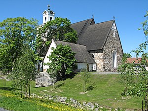
The Church of the Holy Cross (Finnish: Pyhän Ristin kirkko, Swedish: Heliga korsets kyrka) is a medieval fieldstone church in Rauma, Finland. It is located in the UNESCO World Heritage Site of Old Rauma. The church stands by the small stream of Raumanjoki (Rauma river).

Rauma Old Town Hall
Building in Finland
Distance: Approx. 102 meters
Latitude and longitude: 61.12791667,21.51125
Rauma Old Town Hall is a building located in the UNESCO World Heritage Site of Old Rauma in Rauma, Finland. The town hall was built in 1776 by the design of German architect Christian Friedrich Schröder. It represents late Baroque style, although the basic structure of two stories and a clock tower is common in the Medieval towns of Europe.
Rauma shipyard
Distance: Approx. 2694 meters
Latitude and longitude: 61.12347,21.46162
Rauma shipyard (Finnish: Rauman telakka) is a shipyard in Rauma, Finland. It was previously operated by STX Finland which is owned by the South Korean STX Corporation. Rauma shipyard is specialized in large ferries, small cruise ships, multipurpose icebreakers and small naval craft.

Port of Rauma
Port in Rauma, Finland
Distance: Approx. 4485 meters
Latitude and longitude: 61.126389,21.427778
The Port of Rauma is a cargo port located in the city of Rauma, Finland on the shore of the southern part of Gulf of Bothnia. In 2018, the port handled c. 5.8 million tons of international cargo, of which 72% was exports.
Otanlahti Stadium
Pesäpallo stadium in Rauma, Finland
Distance: Approx. 1764 meters
Latitude and longitude: 61.134797,21.482633
Otanlahti Stadium is a pesäpallo stadium located in Rauma, Finland. Since its opening it has been the home field of the Fera, a Superpesis team. The Otanlahti Stadium is located in the Otanlahti Sports Centre by the sea.
Weather in this IP's area
light snow
1 Celsius
-4 Celsius
1 Celsius
1 Celsius
1001 hPa
98 %
1001 hPa
999 hPa
4534 meters
6.32 m/s
11.13 m/s
209 degree
99 %