185.57.104.91 - IP Lookup: Free IP Address Lookup, Postal Code Lookup, IP Location Lookup, IP ASN, Public IP
Country:
 Sweden
Region:
City:
Location:
Time Zone:
Postal Code:
ISP:
ASN:
language:
User-Agent:
Proxy IP:
Blacklist:
IP information under different IP Channel
ip-api
Country
Region
City
ASN
Time Zone
ISP
Blacklist
Proxy
Latitude
Longitude
Postal
Route
db-ip
Country
Region
City
ASN
Time Zone
ISP
Blacklist
Proxy
Latitude
Longitude
Postal
Route
IPinfo
Country
Region
City
ASN
Time Zone
ISP
Blacklist
Proxy
Latitude
Longitude
Postal
Route
IP2Location
185.57.104.91Country
seRegion
blekinge lan
City
karlshamn
Time Zone
Europe/Stockholm
ISP
Language
User-Agent
Latitude
Longitude
Postal
ipdata
Country
Region
City
ASN
Time Zone
ISP
Blacklist
Proxy
Latitude
Longitude
Postal
Route
Popular places and events near this IP address

Karlshamn Municipality
Municipality in Blekinge County, Sweden
Distance: Approx. 858 meters
Latitude and longitude: 56.16666667,14.85
Karlshamn Municipality (Karlshamns kommun) is a municipality in Blekinge County in South Sweden in southern Sweden. It borders to Olofström Municipality, Sölvesborg Municipality, Ronneby Municipality and Tingsryd Municipality. The city of Karlshamn is the seat of the municipality.
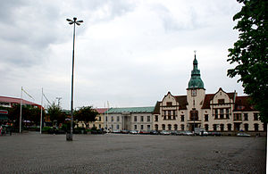
Karlshamn
Place in Blekinge, Sweden
Distance: Approx. 858 meters
Latitude and longitude: 56.16666667,14.85
Karlshamn (Swedish pronunciation: [ˈkɑ̂ːɭshamn]) is a locality and the seat of Karlshamn Municipality in Blekinge County, Sweden. It had 13,576 inhabitants in 2015, out of 31,846 in the municipality. Karlshamn received a Royal Charter and city privileges in 1664, when King Charles X Gustav, in Swedish Karl, realized the strategic location near the Baltic Sea.

Hällaryd
Place in Blekinge, Sweden
Distance: Approx. 6385 meters
Latitude and longitude: 56.20277778,14.94722222
Hällaryd is a locality in Karlshamn Municipality, Blekinge County, Sweden with 546 inhabitants in 2010. It is between Karlshamn and Ronneby, featuring the archipelago south of Matvik with Tärnö as its far out landmark.

Mörrumsån
River in Sweden
Distance: Approx. 7340 meters
Latitude and longitude: 56.15416667,14.74722222
Mörrumsån is a river in Blekinge County and Kronoberg County, Sweden. It is roughly 185 km (115 mi) long, with its tributary in the lake Asnen, from which it flows south, into the Baltic Sea. The river is known among fishing enthusiasts around the world, because of the salmon fishing that is considered to be among the best in Sweden.

Torarp
Place in Blekinge, Sweden
Distance: Approx. 6403 meters
Latitude and longitude: 56.21666667,14.8
Torarp is situated in Karlshamn Municipality, Blekinge County, Sweden with 263 inhabitants as of 2010.

Matvik
Harbor in Sweden
Distance: Approx. 6604 meters
Latitude and longitude: 56.16777778,14.96833333
Matvik is a small harbor in Karlshamn Municipality in southeastern Sweden. It is used for ferry services into the Hällaryd, or Karlshamn, archipelago out south to Tärnö, its biggest island. Matvik is also the largest harbor for private vessels in Karlshamn Municipality with some 600 slots.

Kreativum
Science center in Karlshamn, Sweden
Distance: Approx. 2749 meters
Latitude and longitude: 56.1947,14.8522
Kreativum is a science center located in the city of Karlshamn, Sweden. The center was founded by Peter Enckell and opened by Carl XVI Gustaf on 28 May 1995. Karlshamn Municipality acquired the center in December 2017.

Mieån
River in Sweden
Distance: Approx. 528 meters
Latitude and longitude: 56.16666667,14.86666667
Mieån is a river in Blekinge County and Kronoberg County, Sweden, which it flows south, into the Baltic Sea in the city of Karlshamn.

Elleholms House
Distance: Approx. 6952 meters
Latitude and longitude: 56.16305556,14.75055556
Elleholms House (Swedish: Elleholms hovgård) is a manor house located in Blekinge County, Sweden. It is situated on the islet of the Mörrumsån river in the parish of Elleholm in Karlshamn Municipality.
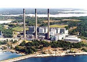
Karlshamn Power Station
Distance: Approx. 2740 meters
Latitude and longitude: 56.15222222,14.8325
Karlshamn Power Station (also known as Stärnö Power Station, Swedish: Karlshamnsverket) is an oil-fired thermal power station on Stärnö peninsula west of Karlshamn. It has had three units, each with a generation capacity of 340 MW, which went in service in 1969, 1971 and 1973. Unit 1 was closed in 2015.

Elleholm
Distance: Approx. 6942 meters
Latitude and longitude: 56.16337778,14.75064722
Elleholm is a former Danish town in Blekinge, Sweden. The town existed between 1450 and 1600, when it was abandoned. The town was based around a former castle, called Sjöborg (meaning "Lake Castle") which today is a Hill fort.
Vägga IP
Sports ground in Karlshamn, Sweden
Distance: Approx. 1391 meters
Latitude and longitude: 56.16388889,14.88083333
Vägga IP is a football stadium in Karlshamn, Sweden and the home stadium for the football teams Högadals IS and IFK Karlshamn.
Weather in this IP's area
clear sky
-1 Celsius
-4 Celsius
-1 Celsius
-1 Celsius
1029 hPa
71 %
1029 hPa
1024 hPa
10000 meters
2.55 m/s
3.17 m/s
336 degree