185.55.203.243 - IP Lookup: Free IP Address Lookup, Postal Code Lookup, IP Location Lookup, IP ASN, Public IP
Country:
 Ireland
Region:
City:
Location:
Time Zone:
Postal Code:
ISP:
ASN:
language:
User-Agent:
Proxy IP:
Blacklist:
IP information under different IP Channel
ip-api
Country
Region
City
ASN
Time Zone
ISP
Blacklist
Proxy
Latitude
Longitude
Postal
Route
db-ip
Country
Region
City
ASN
Time Zone
ISP
Blacklist
Proxy
Latitude
Longitude
Postal
Route
IPinfo
Country
Region
City
ASN
Time Zone
ISP
Blacklist
Proxy
Latitude
Longitude
Postal
Route
IP2Location
185.55.203.243Country
ieRegion
tipperary
City
tipperary
Time Zone
Europe/Dublin
ISP
Language
User-Agent
Latitude
Longitude
Postal
ipdata
Country
Region
City
ASN
Time Zone
ISP
Blacklist
Proxy
Latitude
Longitude
Postal
Route
Popular places and events near this IP address

Limerick Junction railway station
Station in County Tipperary, Ireland
Distance: Approx. 4231 meters
Latitude and longitude: 52.49944444,-8.20111111
Limerick Junction (Irish: Gabhal Luimnigh) is the interchange railway station for trains originating in Limerick, Dublin Heuston, Cork, Waterford, Tralee and Ennis stations. The station opened on 3 July 1848. The station was highly noted for its layout which prior to 1967 required every train making a stop at the station to make a reversal to do so.

Tipperary (town)
Town in County Tipperary, Ireland
Distance: Approx. 428 meters
Latitude and longitude: 52.474,-8.162
Tipperary (; Irish: Tiobraid Árann, meaning 'well of the Ara'), commonly known as Tipperary Town, is a town and a civil parish in County Tipperary, Ireland. Its population was 4,979 at the 2016 census. It is also an ecclesiastical parish in the Roman Catholic Archdiocese of Cashel and Emly, and is in the historical barony of Clanwilliam.

Tipperary railway station
Railway station in Tipperary, Ireland
Distance: Approx. 506 meters
Latitude and longitude: 52.4703,-8.1614
Tipperary Station is a railway station that serves the town of Tipperary, County Tipperary in Ireland. It is approximately 500 metres from centre of town. It has a weekday passenger service of two trains to Limerick Junction and two to Waterford.
Tipperary Midwest Community Radio
Radio station
Distance: Approx. 311 meters
Latitude and longitude: 52.475,-8.15944444
Tipperary Midwest Community Radio is a non-profit, community radio station which broadcasts from St. Michael's Street, Tipperary Town, Ireland. It broadcasts on the frequency 104.8fm and 106.7fm in the Cashel area and can be heard in parts of eight counties in Ireland namely: Tipperary, Limerick, Cork, Waterford, Kilkenny, Carlow, Laois and Offaly.

Shronell
Civil parish in County Tipperary, Ireland
Distance: Approx. 5309 meters
Latitude and longitude: 52.46666667,-8.23333333
Shronell, Shrone Hill, or Shronel (Irish: Srónaill) is a civil parish and townland near the villages of Lattin and Emly in County Tipperary, Ireland. It is situated 3 miles southwest of Tipperary town on the R515 regional road.

Arravale Rovers GAA
Distance: Approx. 487 meters
Latitude and longitude: 52.46904722,-8.15750278
Arravale Rovers GAA (Irish: Fánaithe Gleann Árann) is Gaelic Athletic Association (GAA) club in County Tipperary, Ireland. Based in the town of Tipperary, it competes at senior level in Tipperary GAA county and divisional hurling and Gaelic football championships and leagues. Now part of the West Division of Tipperary GAA, it formerly played in the South Division Up to 1930.
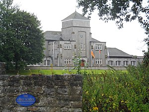
The Abbey School (Tipperary)
School in Republic of Ireland
Distance: Approx. 351 meters
Latitude and longitude: 52.471583,-8.160133
The Abbey School (formerly Abbey CBS) is a Christian Brothers Secondary School in the town of Tipperary, County Tipperary, Ireland. The Abbey is an all-boys school and has 332 students In recent years the school has been extended twice. The first extension is known as the "Edmund Rice Wing" and contains an area for student lockers as well as a Construction Studies room, Woodwork room and Technology laboratory.
Tipperary Racecourse
Distance: Approx. 4706 meters
Latitude and longitude: 52.502287,-8.206336
Tipperary Racecourse is a horse racing venue in County Tipperary, Ireland which stages both National Hunt and Flat racing. The course is located adjacent to Limerick Junction railway station and approximately two miles from Tipperary town. Tipperary Racecourse is owned by Horse Racing Ireland.

Soloheadbeg ambush
1919 IRA attack on Irish police
Distance: Approx. 5206 meters
Latitude and longitude: 52.52,-8.16
The Soloheadbeg ambush took place on 21 January 1919, when members of the Irish Volunteers (or Irish Republican Army [IRA]) ambushed Royal Irish Constabulary (RIC) officers who were escorting a consignment of gelignite explosives at Soloheadbeg, County Tipperary. Two RIC officers were killed and their weapons and the explosives were stolen. The Volunteers acted on their own initiative and had not sought authorisation for their action.

Tipperary Excel
Distance: Approx. 326 meters
Latitude and longitude: 52.474841,-8.159888
Tipperary Excel is an arts and cultural centre located in Tipperary, Ireland, opened in 2001.
Carron fort
Ringfort in County Tipperary, Ireland
Distance: Approx. 2772 meters
Latitude and longitude: 52.493446,-8.179824
Carron fort is a ringfort (rath) and National Monument located in County Tipperary, Ireland.

R664 road (Ireland)
Road in County Tipperary, Ireland
Distance: Approx. 458 meters
Latitude and longitude: 52.470583,-8.160869
The R664 road is a regional road in County Tipperary, Ireland. It runs from Tipperary's main street southwards, crossing the River Ara and the railway line before meeting the R663 (Bansha–Garryspillane road).
Weather in this IP's area
overcast clouds
5 Celsius
2 Celsius
5 Celsius
5 Celsius
1018 hPa
94 %
1018 hPa
1000 hPa
10000 meters
5.05 m/s
10.13 m/s
315 degree
100 %