185.54.76.7 - IP Lookup: Free IP Address Lookup, Postal Code Lookup, IP Location Lookup, IP ASN, Public IP
Country:
Region:
City:
Location:
Time Zone:
Postal Code:
ISP:
ASN:
language:
User-Agent:
Proxy IP:
Blacklist:
IP information under different IP Channel
ip-api
Country
Region
City
ASN
Time Zone
ISP
Blacklist
Proxy
Latitude
Longitude
Postal
Route
db-ip
Country
Region
City
ASN
Time Zone
ISP
Blacklist
Proxy
Latitude
Longitude
Postal
Route
IPinfo
Country
Region
City
ASN
Time Zone
ISP
Blacklist
Proxy
Latitude
Longitude
Postal
Route
IP2Location
185.54.76.7Country
Region
baden-wurttemberg
City
ettlingen
Time Zone
Europe/Berlin
ISP
Language
User-Agent
Latitude
Longitude
Postal
ipdata
Country
Region
City
ASN
Time Zone
ISP
Blacklist
Proxy
Latitude
Longitude
Postal
Route
Popular places and events near this IP address

Wolfartsweier
Borough of Karlsruhe in Baden-Württemberg, Germany
Distance: Approx. 5025 meters
Latitude and longitude: 48.97444444,8.45361111
Wolfartsweier is a village and a quarter of Karlsruhe, Baden-Württemberg, Germany. Its population is 3,068 (2020). It was first mentioned in 1261 AD under the name of "Wolvoldeswilere".

Ettlingen
Town in Baden-Württemberg, Germany
Distance: Approx. 1009 meters
Latitude and longitude: 48.93333333,8.4
Ettlingen (German pronunciation: [ˈɛtlɪŋən] ; South Franconian: Eddlinge) is a town in Baden-Württemberg, Germany, about 8 kilometres (5 mi) south of the city of Karlsruhe and approximately 15 kilometres (9 mi) from the border with Lauterbourg, in France's Bas-Rhin department. Ettlingen is the second largest town in the district of Karlsruhe, after Bruchsal.

Waldbronn
Municipality in Baden-Württemberg, Germany
Distance: Approx. 5316 meters
Latitude and longitude: 48.92444444,8.47583333
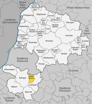
Waldbronn is a municipality in the district of Karlsruhe, in Baden-Württemberg, Germany. It is situated in the northern Black Forest, 11 kilometres (7 miles) southeast of Karlsruhe.
Battle of Ettlingen
Battle of the French Revolutionary Wars
Distance: Approx. 294 meters
Latitude and longitude: 48.94333333,8.40916667
The Battle of Ettlingen or Battle of Malsch (9 July 1796) was fought during the French Revolutionary Wars between the armies of the First French Republic and Habsburg Austria near the town of Malsch, 9 kilometres (6 mi) southwest of Ettlingen. The Austrians under Archduke Charles, Duke of Teschen tried to halt the northward advance of Jean Victor Marie Moreau's French Army of Rhin-et-Moselle along the east bank of the Rhine River. After a tough fight, the Austrian commander found that his left flank was turned.
Wattkopf
Distance: Approx. 2062 meters
Latitude and longitude: 48.93333333,8.43333333
Wattkopf is a mountain of Baden-Württemberg, Germany.

Ettlingen Palace
Distance: Approx. 147 meters
Latitude and longitude: 48.94027778,8.40583333
Ettlingen Palace is a baroque palace in the centre of Ettlingen, a small city in Baden-Württemberg, Germany.

Rüppurr
District of Karlsruhe
Distance: Approx. 2922 meters
Latitude and longitude: 48.96666667,8.4
Rüppurr is a district in the south of Karlsruhe, Baden-Württemberg, Germany, with around 11,000 inhabitants. The district borders on the neighboring town of Ettlingen and is considered to be one of the more affluent residential areas in Karlsruhe. The district is further divided into Alt-Rüppurr, Neu-Rüppurr, Gartenstadt and Rüppurr-Südost.

Friedhof Rüppurr
Cemetery in Karlsruhe, Germany
Distance: Approx. 3363 meters
Latitude and longitude: 48.97075,8.4005
The Friedhof Rüppurr (German for Rüppurr Cemetery) is a grave complex in the southern district of Rüppurr in the city of Karlsruhe in Baden-Württemberg. The cemetery area has a size of approx. 4.2 hectares and is laid out in the style of a rural cemetery.

Grünwettersbach
District of Karlsruhe
Distance: Approx. 3261 meters
Latitude and longitude: 48.95,8.45
Since its incorporation in 1975, Grünwettersbach has been a district in the southeast of Karlsruhe. Together with Palmbach (located further southeast), Grünwettersbach forms the administrative unit Wettersbach. Grünwettersbach is naturally located in the northern Black Forest and has been part of the Central/North Black Forest Nature Park since January 2021.

Beiertheim-Bulach
District of Karlsruhe, Germany
Distance: Approx. 5046 meters
Latitude and longitude: 48.98333333,8.38333333
Beiertheim-Bulach is a district of Karlsruhe, Germany, between Ebertstraße, Hofgut Scheibenhardt, Oberreut and Weiherfeld-Dammerstock. It consists of the formerly independent districts of Beiertheim and Bulach, which are separated by the Alb.

Weiherfeld-Dammerstock
District of Karlsruhe
Distance: Approx. 4756 meters
Latitude and longitude: 48.98333333,8.4
Weiherfeld-Dammerstock is a southern borough of Karlsruhe. In the north it is bordered by the Südtangente and in the east by Ettlinger Straße. The two districts of Weiherfeld and Dammerstock are separated by the Alb and are only connected by a road bridge and two pedestrian bridges.

Hohenwettersbach
District of Karlsruhe
Distance: Approx. 5184 meters
Latitude and longitude: 48.96666667,8.46666667
Hohenwettersbach is a district of the Baden-Württemberg city of Karlsruhe. It is located east of Durlach on the mountain between Wolfartsweier and Grünwettersbach. Since January 2021, Hohenwettersbach has been part of the Central/North Black Forest Nature Park.
Weather in this IP's area
overcast clouds
11 Celsius
10 Celsius
10 Celsius
11 Celsius
999 hPa
64 %
999 hPa
970 hPa
10000 meters
3.58 m/s
9.39 m/s
229 degree
100 %

