185.53.47.76 - IP Lookup: Free IP Address Lookup, Postal Code Lookup, IP Location Lookup, IP ASN, Public IP
Country:
Region:
City:
Location:
Time Zone:
Postal Code:
IP information under different IP Channel
ip-api
Country
Region
City
ASN
Time Zone
ISP
Blacklist
Proxy
Latitude
Longitude
Postal
Route
Luminati
Country
ASN
Time Zone
Europe/Berlin
ISP
Vodafone GmbH
Latitude
Longitude
Postal
IPinfo
Country
Region
City
ASN
Time Zone
ISP
Blacklist
Proxy
Latitude
Longitude
Postal
Route
IP2Location
185.53.47.76Country
Region
baden-wurttemberg
City
schwabisch hall
Time Zone
Europe/Berlin
ISP
Language
User-Agent
Latitude
Longitude
Postal
db-ip
Country
Region
City
ASN
Time Zone
ISP
Blacklist
Proxy
Latitude
Longitude
Postal
Route
ipdata
Country
Region
City
ASN
Time Zone
ISP
Blacklist
Proxy
Latitude
Longitude
Postal
Route
Popular places and events near this IP address

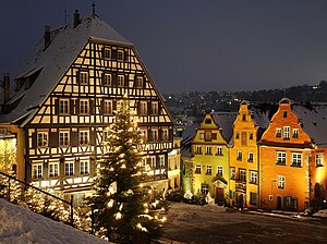
Schwäbisch Hall
City in Baden-Württemberg, Germany
Distance: Approx. 155 meters
Latitude and longitude: 49.11222222,9.7375
Schwäbisch Hall (German pronunciation: [ˌʃvɛːbɪʃ ˈhal]; 'Swabian Hall'; from 1802 until 1934 and colloquially: Hall ) is a city in the German state of Baden-Württemberg located in the valley of the Kocher river, the longest tributary (together with its headwater Lein) of the Neckar river. The closest larger city is Heilbronn, and Schwäbisch Hall lies north-east of the state capital of Stuttgart. It is the seat of the district (Landkreis) of Schwäbisch Hall.

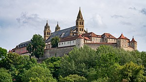
Comburg
Former Benedictine abbey in Germany
Distance: Approx. 1451 meters
Latitude and longitude: 49.10027778,9.74972222
The Comburg (German: [ˈkɔmbʊʁk] ; also Grosscomburg) is a former Benedictine monastery near Schwäbisch Hall, Germany.

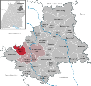
Michelfeld
Municipality in Baden-Württemberg, Germany
Distance: Approx. 4353 meters
Latitude and longitude: 49.10055556,9.68166667
Michelfeld is a town in the district of Schwäbisch Hall in Baden-Württemberg in Germany.

Untermünkheim
Municipality in Baden-Württemberg, Germany
Distance: Approx. 4690 meters
Latitude and longitude: 49.15333333,9.73472222
Untermünkheim is a town in the district of Schwäbisch Hall in Baden-Württemberg in Germany.

Michelbach an der Bilz
Municipality in Baden-Württemberg, Germany
Distance: Approx. 4848 meters
Latitude and longitude: 49.07166667,9.76666667
Michelbach an der Bilz is a town in the district of Schwäbisch Hall in Baden-Württemberg in Germany.

Rosengarten, Baden-Württemberg
Municipality in Baden-Württemberg, Germany
Distance: Approx. 4929 meters
Latitude and longitude: 49.06777778,9.72666667
Rosengarten is a municipality in the district of Schwäbisch Hall in Baden-Württemberg in Germany.

Einkorn (hill)
Hill in Baden-Württemberg, Germany
Distance: Approx. 4482 meters
Latitude and longitude: 49.08333333,9.78333333
The Einkorn is a 510 metre high hill spur in the northern Limpurg Hills near Hessental in the borough of Schwäbisch Hall. It has the ruins of a baroque pilgrimage church that was dedicated to the Fourteen Holy Helpers. The hill is located in the German state of Baden-Württemberg.

Bibers
River in Germany
Distance: Approx. 6989 meters
Latitude and longitude: 49.0486,9.7341
The Bibers is a river in Baden-Württemberg, Germany. The 21.5 kilometers long Bibers flows into the Kocher in Rosengarten.
Sanzenbach
River in Germany
Distance: Approx. 5509 meters
Latitude and longitude: 49.0683,9.7017
Sanzenbach is a small river of Baden-Württemberg, Germany. It flows into the Bibers near Rosengarten.

Schwäbisch Hall-Hessental station
Railway station in Germany
Distance: Approx. 2589 meters
Latitude and longitude: 49.096825,9.766908
Schwäbisch Hall-Hessental station (called Hessental until 1933) is the more important of the two stations of the major district town of Schwäbisch Hall in the German state of Baden-Württemberg. It is a junction station (classified by Deutsche Bahn as a category 4 station) where the Waiblingen–Schwäbisch Hall railway (Murrbahn) branches off the Crailsheim–Heilbronn railway (Hohenlohebahn).

Schwäbisch Hall station
Railway station in Schwäbisch Hall, Germany
Distance: Approx. 513 meters
Latitude and longitude: 49.10815,9.733966
Schwäbisch Hall station is located in Schwäbisch Hall in the German state of Baden-Württemberg. It lies on the Crailsheim–Heilbronn railway (Hohenlohebahn) and is classified by Deutsche Bahn as a category 6 station.
Bausparkasse Schwäbisch Hall
Distance: Approx. 629 meters
Latitude and longitude: 49.11326,9.74719
Bausparkasse Schwäbisch Hall AG (German pronunciation: [ˈbaʊ̯ʃpaːɐ̯ˌkasə ˌʃvɛːbɪʃ ˈhal aːˌɡeː] ) is a building society in Germany, active abroad with subsidiaries in Eastern Europe and China. It has more than 10 million customers. Shareholders are the cooperative central bank DZ Bank (96.8 percent) in Frankfurt am Main and around 600 cooperative banks.
Weather in this IP's area
scattered clouds
3 Celsius
-1 Celsius
2 Celsius
4 Celsius
1024 hPa
79 %
1024 hPa
972 hPa
10000 meters
4.63 m/s
260 degree
40 %