185.53.33.182 - IP Lookup: Free IP Address Lookup, Postal Code Lookup, IP Location Lookup, IP ASN, Public IP
Country:
Region:
City:
Location:
Time Zone:
Postal Code:
ISP:
ASN:
language:
User-Agent:
Proxy IP:
Blacklist:
IP information under different IP Channel
ip-api
Country
Region
City
ASN
Time Zone
ISP
Blacklist
Proxy
Latitude
Longitude
Postal
Route
db-ip
Country
Region
City
ASN
Time Zone
ISP
Blacklist
Proxy
Latitude
Longitude
Postal
Route
IPinfo
Country
Region
City
ASN
Time Zone
ISP
Blacklist
Proxy
Latitude
Longitude
Postal
Route
IP2Location
185.53.33.182Country
Region
trentino-alto adige
City
sluderno
Time Zone
Europe/Rome
ISP
Language
User-Agent
Latitude
Longitude
Postal
ipdata
Country
Region
City
ASN
Time Zone
ISP
Blacklist
Proxy
Latitude
Longitude
Postal
Route
Popular places and events near this IP address

Rom (river)
River in Switzerland and Italy
Distance: Approx. 3165 meters
Latitude and longitude: 46.6705,10.5445
The Rom (Romansh: Rom; Italian: Ram; German: Rombach in Switzerland or Rambach in South Tyrol (Italy) is a river in Switzerland and Italy. The 24.7-kilometre (15.3 mi) long river is a tributary of the Adige. It rises in the Ortler Alps, close to the Fuorn Pass.
Marienberg Abbey
Benedictine abbey in Mals, Vinschgau in South Tyrol, northern Italy
Distance: Approx. 6863 meters
Latitude and longitude: 46.70666667,10.51944444
Marienberg Abbey (German: Abtei Marienberg; Italian: Abbazia Monte Maria) is a Benedictine abbey in Mals, Vinschgau in South Tyrol, northern Italy. It was founded in 1149 or 1150 by Ulrich von Tarasp and other nobles. It has maintained a long tradition of education and, at 1,340 m, it is Europe’s highest abbey.

Glurns
Comune in Trentino-Alto Adige/Südtirol, Italy
Distance: Approx. 2685 meters
Latitude and longitude: 46.66666667,10.55
Glurns (German pronunciation: [ˈɡlʊrns]; Italian: Glorenza [ɡloˈrɛntsa]) is an urban comune (Stadt) in South Tyrol in northern Italy, located about 80 kilometres (50 mi) northwest of Bolzano. It is one of I Borghi più belli d'Italia ("The most beautiful villages of Italy").

Mals
Comune in Trentino-Alto Adige/Südtirol, Italy
Distance: Approx. 4771 meters
Latitude and longitude: 46.7,10.55
Mals (German pronunciation: [mals]; Italian: Malles Venosta [ˈmallez veˈnɔsta]) is a comune (municipality) and a village in South Tyrol in northern Italy, located about 70 kilometres (43 mi) northwest of Bolzano, on the border with Switzerland and Austria.

Prad am Stilfser Joch
Comune in Trentino-Alto Adige/Südtirol, Italy
Distance: Approx. 5447 meters
Latitude and longitude: 46.61666667,10.6
Prad am Stilfser Joch (German pronunciation: [praˑt am ˈʃtɪlfsɐ jɔx]; Italian: Prato allo Stelvio [ˈpraːto ˈallo ˈstɛlvjo]), often abbreviated to Prad, is a comune (municipality) and a village in South Tyrol in northern Italy, located about 60 kilometres (37 mi) west of the city of Bolzano, on the border with Switzerland, and near the Stelvio Pass.

Schluderns
Comune in Trentino-Alto Adige/Südtirol, Italy
Distance: Approx. 273 meters
Latitude and longitude: 46.66666667,10.58333333
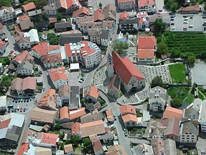
Schluderns (German pronunciation: [ʃluˈdɛrns]; Italian: Sluderno [zluˈdɛrno]) is a comune (municipality) and a village in South Tyrol in northern Italy, located about 60 km (37 mi) northwest of Bolzano.

Battle of Calven
Battle during the Swabian War
Distance: Approx. 5703 meters
Latitude and longitude: 46.6678,10.5105
The Battle of Calven (Romansh: Chalavaina)1 took place on 22 May 1499 at the exit of the Val Müstair in the Grisons (now part of Switzerland) to the Vinschgau in County of Tyrol (now part of Italy) between the forces of King Maximilian I of the House of Habsburg and those of the free federation of the Three Leagues of the Grisons. It was the decisive battle in the southern Grisons of the Swabian War; after the defeat of the Habsburg troops, the king had to abandon his attempts to control the Engadin and the Val Müstair. The focus of operations in the Swabian War subsequently shifted again to the northern border of the Old Swiss Confederacy.

Saldurbach
River in Italy
Distance: Approx. 2048 meters
Latitude and longitude: 46.6461,10.5847
The Saldurbach (Italian: Saldura) is a stream located in South Tyrol, Italy. It flows into the Punibach close to its confluence with the Adige near Prad am Stilfser Joch.

Suldenbach
River in Italy
Distance: Approx. 4050 meters
Latitude and longitude: 46.63305556,10.61166667
The Suldenbach (Italian: Rio Solda) is a stream located in South Tyrol, Italy. It flows into the Adige in Prad am Stilfser Joch.

Burgeis
Distance: Approx. 6682 meters
Latitude and longitude: 46.71055556,10.52888889
Burgeis (Italian: Burgusio, Romansh: ) is the largest frazione of the comune of Mals, Italy, and sits at an altitude of 1216m in Vinschgau in South Tyrol beneath the mountain Watles (2557) on the upper reaches of the Adige. The name goes all the way back to a Roman founding, as a fort on the "Via Claudia Augusta", which runs through the village. This fort later gave the name of the Edelfreien von Burgus-Wanga, whose arms the village bears today.

Mals Heath
Distance: Approx. 6865 meters
Latitude and longitude: 46.71944444,10.54416667
The Mals Heath (German: Malser Haide) is located in South Tyrol, Italy; it is one of the largest ancient landslides and one of the most remarkable landscape features in the Alps. It is located in the Upper Vinschgau where a broad pass (the Reschen Pass) crosses the main Alpine divide into the Inn Valley (Austria). It extends from Glurns via Laatsch, Schleis, and Burgeis up to Plawenn.

St. Benedikt (Mals)
Distance: Approx. 4508 meters
Latitude and longitude: 46.6903,10.5395
St. Benedikt is a pre-Romanesque church in Mals, South Tyrol, known for its Carolingian-era frescoes. It was built in the second half of the 8th century.
Weather in this IP's area
overcast clouds
5 Celsius
3 Celsius
5 Celsius
5 Celsius
1015 hPa
92 %
1015 hPa
763 hPa
9266 meters
2.3 m/s
2.66 m/s
167 degree
92 %
