Country:
 Italy
ItalyRegion:
City:
Latitude and Longitude:
Time Zone:
Postal Code:
IP information under different IP Channel
ip-api
Country
Region
City
ASN
Time Zone
ISP
Blacklist
Proxy
Latitude
Longitude
Postal
Route
IPinfo
Country
Region
City
ASN
Time Zone
ISP
Blacklist
Proxy
Latitude
Longitude
Postal
Route
MaxMind
Country
Region
City
ASN
Time Zone
ISP
Blacklist
Proxy
Latitude
Longitude
Postal
Route
Luminati
Country
ITASN
Time Zone
Europe/Rome
ISP
Irideos S.p.A.
Latitude
Longitude
Postal
db-ip
Country
Region
City
ASN
Time Zone
ISP
Blacklist
Proxy
Latitude
Longitude
Postal
Route
ipdata
Country
Region
City
ASN
Time Zone
ISP
Blacklist
Proxy
Latitude
Longitude
Postal
Route
Popular places and events near this IP address
Moleskine
Italian manufacturing company
Distance: Approx. 1202 meters
Latitude and longitude: 45.49544444,9.18258333
Moleskine (Italian pronunciation: [moleˈskiːne]) is an Italian manufacturer, papermaker, and product designer. It was founded in 1997 by Maria Sebregondi and is based in Milan, Italy. It produces and designs luxury notebooks, as well as planners, sketchbooks, leather backpacks, holdalls, journals, wallets, various accessories, and stationery.
Islamic Cultural Institute (Milan)
Islamic organization based in Italy
Distance: Approx. 598 meters
Latitude and longitude: 45.49690833,9.17508611
The Islamic Cultural Institute in Milan, Italy was shut down by Italian authorities, based on an association with terrorism according to counter-terror analysts at the Guantanamo Bay detention camps in Cuba. However, in 2008 it was functioning again. The current president of the institute, as well as the associated mosque, is Abdel Hamid Shaari.
Ghisolfa
Quartiere of Milan in Lombardy, Italy
Distance: Approx. 580 meters
Latitude and longitude: 45.49527778,9.16083333
Ghisolfa is a district ("quartiere") of Milan, Italy, part of the Zone 8 administrative division of the city, located north-west of the city centre. It is named after the "Ghisolfa Bridge" ("Ponte della Ghisolfa") overpass, part of the external Circonvallazione ring road enclosing the centre of Milan. In turn, the bridge was named after two cascine (farm houses), "Cascina Ghisolfa" and "Cascina Ghisolfetta", that existed in the area before the urbanization of the mid 20th century.
Dergano
Quartier of Milan in Lombardy, Italy
Distance: Approx. 935 meters
Latitude and longitude: 45.5025,9.17722222
Dergano is a district of Milan, Italy. It is an area located within Zone 9 of the city.

Bovisa
Quartiere of Milan in Lombardy, Italy
Distance: Approx. 507 meters
Latitude and longitude: 45.50138889,9.16388889
Bovisa (Western Lombard: [buˈʋiːza], Italian: [boˈviːza]) is a district (quartiere) of Milan, Italy, located north of the city center, in the Zone 9. The name is supposedly derived from the Italian word bove, meaning ox, as the area developed from an ancient rural settlement.
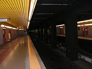
Maciachini (Milan Metro)
Milan metro station
Distance: Approx. 1346 meters
Latitude and longitude: 45.49805556,9.18472222
Maciachini is an underground station on Line 3 of the Milan Metro which opened on December 8, 2003, thirteen years after the opening of the original trunk of the line. This station was the northern terminus of the line until March 26, 2011, with the extension of the line to Comasina. The station is located at Piazzale Carlo Maciachini on the Milan Ring Road, in the municipality of Milan.

Dergano (Milan Metro)
Milan metro station
Distance: Approx. 1302 meters
Latitude and longitude: 45.50555556,9.17972222
Dergano is a station on Line 3 of the Milan Metro which opened on March 26, 2011, twenty-one years after the opening of the original trunk of the line. It is the first station following Maciachini, the former northern terminus of the line. Dergano station was opened with other three stations, forming the branch from Dergano with Comasina.

Messina tram depot
Distance: Approx. 1355 meters
Latitude and longitude: 45.48595833,9.17254444
The Messina tram depot (in Italian: Deposito tranviario Messina) is the largest tram depot in Milan, Italy, and one of the largest in the world. It is located at street number 41 of Via Messina, close to the Monumentale cemetery. The building of the depot, which dates back to 1912, is a prominent example of early 20th century Milanese industrial architecture, and one of the most important examples of cast-iron architecture in Italy.

Milano Lancetti railway station
Underground railway station in Milan, Italy
Distance: Approx. 732 meters
Latitude and longitude: 45.495,9.17611111
Milano Lancetti is an underground railway station in Milan, Italy. It opened in 1997 as part of the Milan Passante railway, as its north-western gate. It is located on Viale Vincenzo Lancetti.

Milano Bovisa railway station
Railway station in Bovisa, Milan, Italy
Distance: Approx. 848 meters
Latitude and longitude: 45.5025,9.15916667
Milano Bovisa is a railway station in Bovisa, Milan, Italy. It opened in 1879 and is now one of the key nodes of the Milan suburban railway service, and of the Trenord regional network in northern Lombardy. It is located in Piazza Emilio Alfieri.

Quartiere Campo dei Fiori
Quartiere of Milan in Lombardy, Italy
Distance: Approx. 1054 meters
Latitude and longitude: 45.49916667,9.15416667
Quartiere Campo dei Fiori is a small district in Milan, Italy. The district measures 400 by 300 meters (1,310 by 980 ft). It is located in the north-western outskirts of the city, and is a part of Zone 8.
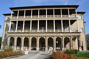
Villa Simonetta
Distance: Approx. 690 meters
Latitude and longitude: 45.49143056,9.1684
Villa Simonetta is a villa Renaissance located in Milan at Via Stilicone 36, built at the end of the 15th century and then enlarged and renovated several times. Today, the villa is municipal property and is home to the Civica Scuola di Musica «Claudio Abbado».
Weather in this IP's area
light rain
22 Celsius
22 Celsius
20 Celsius
23 Celsius
1014 hPa
84 %
1014 hPa
998 hPa
10000 meters
1.54 m/s
350 degree
75 %
06:53:40
19:48:33