Country:
 Germany
Region:
City:
Latitude and Longitude:
Time Zone:
Postal Code:
IP information under different IP Channel
ip-api
Country
Region
City
ASN
Time Zone
ISP
Blacklist
Proxy
Latitude
Longitude
Postal
Route
IPinfo
Country
Region
City
ASN
Time Zone
ISP
Blacklist
Proxy
Latitude
Longitude
Postal
Route
MaxMind
Country
Region
City
ASN
Time Zone
ISP
Blacklist
Proxy
Latitude
Longitude
Postal
Route
Luminati
Country
DEASN
Time Zone
Europe/Berlin
ISP
TelemaxX Telekommunikation GmbH
Latitude
Longitude
Postal
db-ip
Country
Region
City
ASN
Time Zone
ISP
Blacklist
Proxy
Latitude
Longitude
Postal
Route
ipdata
Country
Region
City
ASN
Time Zone
ISP
Blacklist
Proxy
Latitude
Longitude
Postal
Route
Popular places and events near this IP address
Böblingen (district)
District in Baden-Württemberg, Germany
Distance: Approx. 3405 meters
Latitude and longitude: 48.7,9.01
Böblingen is a Landkreis (district) in the middle of Baden-Württemberg, Germany. Neighboring districts are (from west clockwise) Calw, Enz, Ludwigsburg, (district) Stuttgart, and the districts Esslingen, Reutlingen and Tübingen.
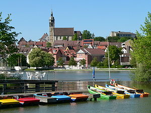
Böblingen
Town in Baden-Württemberg, Germany
Distance: Approx. 3112 meters
Latitude and longitude: 48.68555556,9.01527778
Böblingen (German pronunciation: [ˈbøːblɪŋən] ; Swabian: Beblenga) is a town in Baden-Württemberg, Germany, seat of Böblingen District. Sindelfingen and Böblingen are contiguous.
Böblingen Airport
Former airport of Stuttgart, Baden-Württemberg, Germany (1915–1992)
Distance: Approx. 1966 meters
Latitude and longitude: 48.68333333,9
Böblingen Airport (German: Flughafen Böblingen) (IATA: PHM) was built in the mid-1920s for the city of Stuttgart, the capital of the German state of Baden-Württemberg. Bordered by Calwer Straße (K1073) and the E41, it lies northwest of Böblingen and south of the Daimler factory in Sindelfingen. An aircraft industry developed around this airfield, which was used by the military during the Second World War.
Sporthalle (Böblingen)
Distance: Approx. 3245 meters
Latitude and longitude: 48.67813889,9.01736111
Sporthalle was an indoor arena located in Böblingen, Germany. It opened in 1966 and was torn down in 2008. Sporthalle had a capacity to hold 6,500 people.

Ehningen
Municipality in Baden-Württemberg, Germany
Distance: Approx. 3481 meters
Latitude and longitude: 48.65888889,8.94027778
Ehningen is a town in the district of Böblingen in Baden-Württemberg in Germany.

Glaspalast Sindelfingen
Sports arena in Sindelfingen, Germany
Distance: Approx. 3941 meters
Latitude and longitude: 48.715955,8.983662
Glaspalast Sindelfingen is an indoor arena, in Sindelfingen, Germany. The arena holds 5,250 people. It is primarily used for indoor athletics and concerts.

Böblingen station
Railway station in Böblingen, Germany
Distance: Approx. 2403 meters
Latitude and longitude: 48.6875,9.00472222
Böblingen station is located on the Stuttgart–Horb railway (German: Gäubahn) and is at the start of the Rankbach Railway (Rankbachbahn) and the Schönbuch Railway (Schönbuchbahn). It is served by regional services and Stuttgart S-Bahn line S 1. Until 2002 it was served by Intercity-Express and Cisalpino services.
Krebsbach (Würm)
River in Baden-Württemberg, Germany
Distance: Approx. 3691 meters
Latitude and longitude: 48.6575,8.93833333
Krebsbach (in its upper course: Hungergraben) is a river which flows through the South Western state of Germany, Baden-Württemberg, Germany. It flows into the Würm in Ehningen.

Goldberg (Württ) station
Railway station in Germany
Distance: Approx. 3802 meters
Latitude and longitude: 48.6965,9.0197
Goldberg station is a railway station in the Goldberg district of the municipality of Böblingen, located in the Böblingen district in Baden-Württemberg, Germany.

Sindelfingen station
Railway station in Sindelfingen, Germany
Distance: Approx. 3156 meters
Latitude and longitude: 48.70388,8.99923
Sindelfingen station (German: Bahnhof Sindelfingen) is a railway station in the municipality of Sindelfingen, located in the Böblingen district in Baden-Württemberg, Germany. It is part of the Stuttgart S-Bahn and trains go at a frequency of two trains an hour in both directions. Across the street is the Sindelfingen central bus station, and in the opposite direction it borders the Mercedes-Benz plant.
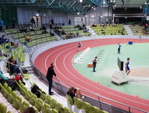
2004 World Masters Athletics Indoor Championships
International athletics championship event
Distance: Approx. 3941 meters
Latitude and longitude: 48.715955,8.983662
2004 World Masters Athletics Indoor Championships is the first in a series of World Masters Athletics Indoor Championships (also called World Masters Athletics Championships Indoor, or WMACi) that were held following the success of both stadia and non-stadia World Masters Athletics Outdoor Championships, This inaugural WMA Indoor Championships took place in Sindelfingen, Germany, from 10 to 14 March 2004. The main venue was Glaspalast Sindelfingen, : 1 which has a banked four-lane indoor track, : 1 : 16 where the turns are raised to neutralize the centrifugal force of athletes running the curves. Supplemental venues included Floschenstadion for throwing events and the tennis hall in Sportwelt VfL Sindelfingen for warming-up purposes.

St. Martin, Sindelfingen
Lutheran church in Württemberg, Germany
Distance: Approx. 3905 meters
Latitude and longitude: 48.711,9.0015
The Martinskirche (St. Martin's church) is the Lutheran main church in Sindelfingen, Baden-Württemberg, Germany. It was built in Romanesque style as a basilica with a flat wooden ceiling, then part of a monastery.
Weather in this IP's area
broken clouds
12 Celsius
12 Celsius
11 Celsius
13 Celsius
1023 hPa
91 %
1023 hPa
971 hPa
10000 meters
3.6 m/s
320 degree
75 %
07:02:36
19:35:20