185.52.12.54 - IP Lookup: Free IP Address Lookup, Postal Code Lookup, IP Location Lookup, IP ASN, Public IP
Country:
Region:
City:
Location:
Time Zone:
Postal Code:
IP information under different IP Channel
ip-api
Country
Region
City
ASN
Time Zone
ISP
Blacklist
Proxy
Latitude
Longitude
Postal
Route
Luminati
Country
Region
li
City
heerlen
ASN
Time Zone
Europe/Amsterdam
ISP
i3D.net B.V
Latitude
Longitude
Postal
IPinfo
Country
Region
City
ASN
Time Zone
ISP
Blacklist
Proxy
Latitude
Longitude
Postal
Route
IP2Location
185.52.12.54Country
Region
limburg
City
heerlen
Time Zone
Europe/Amsterdam
ISP
Language
User-Agent
Latitude
Longitude
Postal
db-ip
Country
Region
City
ASN
Time Zone
ISP
Blacklist
Proxy
Latitude
Longitude
Postal
Route
ipdata
Country
Region
City
ASN
Time Zone
ISP
Blacklist
Proxy
Latitude
Longitude
Postal
Route
Popular places and events near this IP address

Heerlen
City and municipality in Limburg, Netherlands
Distance: Approx. 81 meters
Latitude and longitude: 50.88333333,5.98333333
Heerlen (Dutch pronunciation: [ˈɦeːrlə(n)] ; Limburgish: Heële [ˈɦeə˦lə]) is a city and a municipality in the southeast of the Netherlands. It is the third largest settlement proper in the province of Limburg. Measured as municipality, it is the fourth municipality in the province of Limburg.

Glaspaleis
Distance: Approx. 502 meters
Latitude and longitude: 50.8879,5.9793
The Glaspaleis (in English: Glass Palace) is a modernist building in Heerlen, Netherlands, built in 1935. Formerly a fashion house and department store, Schunck, it is now the cultural centre of the city. The original name was Modehuis Schunck (Schunck Fashion House), but it was soon nicknamed Glaspaleis, which is now the official name.
Bernardinuscollege
School in Heerlen, the Netherlands
Distance: Approx. 251 meters
Latitude and longitude: 50.882059,5.984655
Bernardinuscollege is a school in Heerlen, the Netherlands. The school was founded by Franciscan friars in 1903 as a monastery, that was later converted to a Hogere Burgerschool, because of the need for education in the wake of the blooming mining industry. In September 1913 the first students arrived.
Schelmentoren
Distance: Approx. 485 meters
Latitude and longitude: 50.88804,5.98044
The Schelmentoren in Heerlen is a Medieval Building that has served as a defendable living tower for the Here van Are (sometimes called the counts van Ahr-Hochstaden) and their successors. As part of the Landsfort Herle, it served as a prison tower. It is believed to be built on command of Theoderich van Are.

Jan Stuyt
Dutch architect (1868–1934)
Distance: Approx. 559 meters
Latitude and longitude: 50.883745,5.974638
Jan Stuyt (21 August 1868, Purmerend - 11 July 1934, The Hague) was a Dutch architect.
Pancratiuskerk
Distance: Approx. 468 meters
Latitude and longitude: 50.8878,5.9801
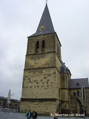
The Pancratiuskerk (St. Pancras Church) is a Roman Catholic church in Heerlen in the Netherlands.
Monseigneur Schrijnen Retreat House
Building in Heerlen, Netherlands
Distance: Approx. 570 meters
Latitude and longitude: 50.884512,5.990661
The Monseigneur Schrijnen Retreat House was designed by the famed architect Frits Peutz (best known for the Glaspaleis) in 1932, and named after the 18th bishop of Roermond Laurentius Josephus Antonius Hubertus Schrijnen (Venlo 30 July 1861 – Roermond 26 March 1932). It is located at the top of one of the steepest hills in Heerlen next to the Molenberg and surrounded by the Aambos (a forest). It is one of the biggest buildings designed by Peutz.
Oliemolen, Heerlen
Watermill in Heerlen, Netherlands
Distance: Approx. 301 meters
Latitude and longitude: 50.884075,5.986882
The Oliemolen (literally Oilmill) is a 16th-century watermill located at the foot of a steep hill in the Aambos, Heerlen in the Netherlands. The name already tells us much about its function, extracting oil, but this was not always the case as it first functioned as a volmolen (a mill to press wool). The mill is fed by the Caumerbeek.
Vroom & Dreesman Building, Heerlen
Distance: Approx. 429 meters
Latitude and longitude: 50.8867,5.9784
The Vroom & Dreesmann Building in Heerlen was a former department store and a hotel, later an office building in Heerlen, the Netherlands, designed by Frits Peutz in 1958. The lower part of the building housed a department store of the Dutch chain Vroom & Dreesmann (V&D). The higher part was a hotel, Hotel Europe.

Royal Theater Heerlen
Distance: Approx. 835 meters
Latitude and longitude: 50.88984,5.97534
Situated close to the Heerlen train station, this egg shaped building dates back to 1938 and was one of the oldest cinemas of the Netherlands. It was designed by Frits Peutz (best known for the Glaspaleis) and J. Bongaerts. The buildings behind it are from a later date and include another building by Peutz (Rivoli, 1958).
Ambachtsschool, Heerlen
Distance: Approx. 559 meters
Latitude and longitude: 50.883745,5.974638
The Ambachtsschool in Heerlen (Jan Stuyt, 1913) is a brick building with distinctive layers of marl (a stone commonly found in the south of Limburg). It is notable as one of the earliest vocational schools in the Netherlands. The building is located on the Burgemeester de Hesselleplein (formerly known as the Lindeplein), in Heerlen.

Aarveld
Neighbourhood in Limburg, Heerlen, Netherlands
Distance: Approx. 333 meters
Latitude and longitude: 50.88166667,5.97944444
Aarveld is a Dutch neighbourhood of Heerlen, in the province of Dutch Limburg. On 1 January 2021, Aarveld had 1,180 inhabitants.
Weather in this IP's area
broken clouds
2 Celsius
-1 Celsius
1 Celsius
4 Celsius
1027 hPa
93 %
1027 hPa
1012 hPa
10000 meters
4.12 m/s
200 degree
75 %


