185.51.175.145 - IP Lookup: Free IP Address Lookup, Postal Code Lookup, IP Location Lookup, IP ASN, Public IP
Country:
Region:
City:
Location:
Time Zone:
Postal Code:
IP information under different IP Channel
ip-api
Country
Region
City
ASN
Time Zone
ISP
Blacklist
Proxy
Latitude
Longitude
Postal
Route
Luminati
Country
Region
eng
City
dennington
ASN
Time Zone
Europe/London
ISP
Syntura Group Limited
Latitude
Longitude
Postal
IPinfo
Country
Region
City
ASN
Time Zone
ISP
Blacklist
Proxy
Latitude
Longitude
Postal
Route
IP2Location
185.51.175.145Country
Region
england
City
framlingham
Time Zone
Europe/London
ISP
Language
User-Agent
Latitude
Longitude
Postal
db-ip
Country
Region
City
ASN
Time Zone
ISP
Blacklist
Proxy
Latitude
Longitude
Postal
Route
ipdata
Country
Region
City
ASN
Time Zone
ISP
Blacklist
Proxy
Latitude
Longitude
Postal
Route
Popular places and events near this IP address

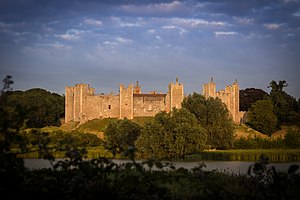
Framlingham Castle
Historic castle in Framlingham, England
Distance: Approx. 461 meters
Latitude and longitude: 52.22405,1.34691
Framlingham Castle is a castle in the market town of Framlingham, Suffolk, England. An early motte and bailey or ringwork Norman castle was built on the Framlingham site by 1148, but this was destroyed (slighted) by Henry II of England in the aftermath of the Revolt of 1173–1174. Its replacement, constructed by Roger Bigod, the Earl of Norfolk, was unusual for the time in having no central keep, but instead using a curtain wall with thirteen mural towers to defend the centre of the castle.

Framlingham
Town in Suffolk, England
Distance: Approx. 137 meters
Latitude and longitude: 52.22207,1.34342
Framlingham is a market town and civil parish in Suffolk, England. Of Anglo-Saxon origin, it appears in the 1086 Domesday Book and was part of Loes Hundred. The parish had a population of 3,342 at the 2011 census and an estimated 4,016 in 2019.
Framlingham College
Public school in Suffolk, England
Distance: Approx. 631 meters
Latitude and longitude: 52.2266,1.3392
Framlingham College is a public school (boarding and day school) in the town of Framlingham, near Woodbridge, Suffolk, England. Together with its preparatory school and nursery at Brandeston Hall, it serves pupils from 3 to 18 years of age.

St Michael the Archangel's Church, Framlingham
Church in United Kingdom
Distance: Approx. 211 meters
Latitude and longitude: 52.2224,1.3444
St Michael's Church in Framlingham, Suffolk is a Church of England church dedicated to Saint Michael. It was the burial site of the Howard family. The church was designated a Grade I listed building in 1966.

Apsey Green
Human settlement in England
Distance: Approx. 1030 meters
Latitude and longitude: 52.222123,1.326967
Apsey Green is a hamlet in Suffolk, England.

Framlingham railway station
Disused railway station in England
Distance: Approx. 308 meters
Latitude and longitude: 52.2185,1.343
Framlingham railway station was located in Framlingham, Suffolk, England and was the terminus station on the Framlingham Branch. It opened on 1 June 1859 and closed to passengers in 1952, and to freight in 1965. The first company to operate trains to the station was the Eastern Counties Railway, which had taken over from the East Suffolk Railway Company that built the branch line.

Thomas Mills High School
Academy in Woodbridge, Suffolk, England
Distance: Approx. 1226 meters
Latitude and longitude: 52.22824,1.32818
Thomas Mills High School & Sixth Form is a co-educational secondary school and sixth form with academy status in Framlingham, Suffolk, England. The current headteacher is Philip J Hurst.

Loes Hundred
A hundred of Suffolk
Distance: Approx. 191 meters
Latitude and longitude: 52.22,1.34
Loes was a hundred of Suffolk, with an area of 31,321 acres (126.75 km2). Loes Hundred was long and thin in shape, around 15 miles (24 km) long and between 2 and 6 miles (9.7 km) wide. It followed the course of the River Deben from Cretingham to Ufford where it crossed Wilford Hundred to Woodbridge where it widened considerably.
Framlingham Town F.C.
Association football club in England
Distance: Approx. 717 meters
Latitude and longitude: 52.22352,1.35181
Framlingham Town Football Club is a football club based in Framlingham, Suffolk, England. Affiliated to the Suffolk County Football Association, they are currently members of the Eastern Counties League Division One North and play at Badingham Road.

Framlingham Mere
Suffolk Wildlife Trust nature reserve
Distance: Approx. 212 meters
Latitude and longitude: 52.223,1.341
Framlingham Mere is a 13.8-hectare nature reserve in Framlingham in Suffolk. It is managed by the Suffolk Wildlife Trust. This site has a lake and wet meadows adjoining Framlingham Castle.

Regency House
House in Framlingham, Suffolk, England
Distance: Approx. 237 meters
Latitude and longitude: 52.22211,1.34514
Regency House is a grade II* listed house at 7 Church Street in Framlingham, Suffolk, England. The house is timber-framed, of three storeys, and dates from the early nineteenth century. It is in use as a shop and house.

Sir Robert Hitcham's Almshouses
Distance: Approx. 168 meters
Latitude and longitude: 52.2224,1.3405
Sir Robert Hitcham's Almshouses are grade II* listed almshouses in New Road, Framlingham, Suffolk, England. They were built in 1654 under the will of Sir Robert Hitcham using materials from the demolished buildings of Framlingham Castle.
Weather in this IP's area
few clouds
7 Celsius
7 Celsius
6 Celsius
8 Celsius
1034 hPa
99 %
1034 hPa
1030 hPa
10000 meters
0.89 m/s
1.79 m/s
249 degree
15 %