Country:
 Switzerland
Region:
City:
Latitude and Longitude:
Time Zone:
Postal Code:
IP information under different IP Channel
ip-api
Country
Region
City
ASN
Time Zone
ISP
Blacklist
Proxy
Latitude
Longitude
Postal
Route
IPinfo
Country
Region
City
ASN
Time Zone
ISP
Blacklist
Proxy
Latitude
Longitude
Postal
Route
MaxMind
Country
Region
City
ASN
Time Zone
ISP
Blacklist
Proxy
Latitude
Longitude
Postal
Route
Luminati
Country
CHRegion
vs
City
saxon
ASN
Time Zone
Europe/Zurich
ISP
netplus.ch SA
Latitude
Longitude
Postal
db-ip
Country
Region
City
ASN
Time Zone
ISP
Blacklist
Proxy
Latitude
Longitude
Postal
Route
ipdata
Country
Region
City
ASN
Time Zone
ISP
Blacklist
Proxy
Latitude
Longitude
Postal
Route
Popular places and events near this IP address

International Seminary of Saint Pius X
Distance: Approx. 2708 meters
Latitude and longitude: 46.1562435,7.2042985
The International Seminary of Saint Pius X in Écône, Valais, Switzerland, is the premier seminary of the Roman Catholic traditionalist Society of Saint Pius X (SSPX). The seminary is one of the six houses for formation for the future priests of the Society of Saint Pius X. The Seminary was founded in 1970 by Archbishop Marcel Lefebvre, and his tomb can be found there.
Écône
Human settlement in Switzerland
Distance: Approx. 2844 meters
Latitude and longitude: 46.15611111,7.2075
Écône is an area in the municipality of Riddes, district of Martigny, in the canton of Valais, Switzerland.

Charrat
Former municipality in Valais, Switzerland
Distance: Approx. 4500 meters
Latitude and longitude: 46.11666667,7.13333333
Charrat is a former municipality in the district of Martigny in the canton of Valais in Switzerland. On 1 January 2021 the former municipality of Charrat merged into the municipality of Martigny.

Riddes
Municipality in Valais, Switzerland
Distance: Approx. 4206 meters
Latitude and longitude: 46.16666667,7.21666667
Riddes is a municipality in the district of Martigny in the canton of Valais in Switzerland.

Saillon
Municipality in Valais, Switzerland
Distance: Approx. 3393 meters
Latitude and longitude: 46.16666667,7.18333333
Saillon (French pronunciation: [sajɔ̃]) is a municipality in the district of Martigny in the canton of Valais in Switzerland.

Saxon, Switzerland
Municipality in Valais, Switzerland
Distance: Approx. 2057 meters
Latitude and longitude: 46.15,7.16666667
Saxon is a municipality, in the district of Martigny, in the canton of Valais, in Switzerland.

Col du Lein
Mountain pass in the Swiss Alps
Distance: Approx. 3205 meters
Latitude and longitude: 46.11333333,7.15916667
Col du Lein (el. 1623 m.) is a high mountain pass in the Alps in the canton of Valais in Switzerland. It connects Saxon in the valley of the Rhône with Vollèges in the Val de Bagnes.

La Tzoumaz
Ski resort in the Valais canton, Swiss Alps
Distance: Approx. 3871 meters
Latitude and longitude: 46.1447,7.23306
La Tzoumaz (formally known as Les Mayens-de-Riddes) is a ski resort in the Swiss Alps, in the canton of Valais. It is part of the "Four Valleys" ski area, which consists of various ski resorts, including Verbier, Nendaz, Veysonnaz, La Tzoumaz, and Thyon. As such it has direct access to over 400 km of runs.

Pierre Avoi
Mountain in Switzerland
Distance: Approx. 2351 meters
Latitude and longitude: 46.11811111,7.20013889
The Pierre Avoi is a mountain of the Swiss Pennine Alps, overlooking Saxon in the canton of Valais. It is located on the chain between the main Rhone valley and the valley of Bagnes. The closest locality is Verbier, from where several trails lead to the summit of Pierre Avoi.
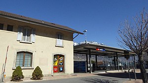
Saxon railway station
Railway station in Switzerland
Distance: Approx. 1694 meters
Latitude and longitude: 46.14938306,7.17343611
Saxon railway station (French: Gare de Saxon, German: Bahnhof Saxon) is a railway station in the municipality of Saxon, in the Swiss canton of Valais. It is an intermediate stop on the Simplon line and is served by local trains only.

Saillon Castle
Distance: Approx. 3823 meters
Latitude and longitude: 46.17052,7.182654
Saillon Castle or Bayard Tower is a ruined castle in the municipality of Saillon of the Canton of Valais in Switzerland. It is a Swiss heritage site of national significance.
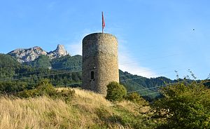
Saxon Castle
Distance: Approx. 920 meters
Latitude and longitude: 46.14297,7.17757
Saxon Castle is a ruined castle in the municipality of Saxon of the Canton of Valais in Switzerland.
Weather in this IP's area
overcast clouds
17 Celsius
17 Celsius
14 Celsius
17 Celsius
1014 hPa
72 %
1014 hPa
910 hPa
10000 meters
1.62 m/s
2.52 m/s
143 degree
88 %
07:01:02
19:57:02