Country:
Region:
City:
Latitude and Longitude:
Time Zone:
Postal Code:
IP information under different IP Channel
ip-api
Country
Region
City
ASN
Time Zone
ISP
Blacklist
Proxy
Latitude
Longitude
Postal
Route
Luminati
Country
ASN
Time Zone
Europe/Dublin
ISP
Hibernia Services Limited
Latitude
Longitude
Postal
IPinfo
Country
Region
City
ASN
Time Zone
ISP
Blacklist
Proxy
Latitude
Longitude
Postal
Route
db-ip
Country
Region
City
ASN
Time Zone
ISP
Blacklist
Proxy
Latitude
Longitude
Postal
Route
ipdata
Country
Region
City
ASN
Time Zone
ISP
Blacklist
Proxy
Latitude
Longitude
Postal
Route
Popular places and events near this IP address

Shankill railway station
Railway station in Shankill, Dublin
Distance: Approx. 1653 meters
Latitude and longitude: 53.2363,-6.117
Shankill railway station (Irish: Stáisiún Sheanchill) serves Shankill, in Dún Laoghaire–Rathdown, Ireland.

Loughlinstown
Outer suburb of Dublin, Ireland
Distance: Approx. 992 meters
Latitude and longitude: 53.25,-6.13333333
Loughlinstown (Irish: Baile Uí Lachnáin, meaning 'O'Laughnan's town') is a southern Dublin suburb, located in Dún Laoghaire–Rathdown, on the N11 national road. Loughlinstown is the location of St. Columcille's Hospital, which serves both south Dublin and Wicklow.

Cherrywood, Dublin
Developing suburb near Dublin, Ireland
Distance: Approx. 309 meters
Latitude and longitude: 53.24461111,-6.14147222
Cherrywood (Irish: Coill na Silíní) is a developing suburb of Dublin, Ireland, bordering Cabinteely, Loughlinstown and Rathmichael. It is located to the southeast of the city, in Dún Laoghaire–Rathdown. The development commenced on a greenfield site in 1998 and primarily comprises Cherrywood Business Park and new residential and retail development.

Rathmichael
Remote southern suburb of Dublin, Ireland
Distance: Approx. 1248 meters
Latitude and longitude: 53.23583333,-6.15555556
Rathmichael (Irish: Ráth Mhichíl) is a suburb south-east of Dublin, in the local government area of Dún Laoghaire–Rathdown, near the southern border of the traditional County Dublin. It is situated west of Shankill from which it is, roughly, separated by the M50/M11 motorways. It is also a civil parish in the barony of Rathdown.

Ballybrack
Suburb of Dublin, Ireland
Distance: Approx. 1608 meters
Latitude and longitude: 53.2531,-6.124466
Ballybrack (Irish: An Baile Breac, meaning 'the speckled townland') is a residential suburb of Dublin, in the south of County Dublin. It is in Dún Laoghaire–Rathdown, Ireland. It is southwest of Killiney, northeast of Loughlinstown, east of Cabinteely and north of Shankill.

St. Columcille's Hospital
Hospital in Dún Laoghaire–Rathdown, Ireland
Distance: Approx. 361 meters
Latitude and longitude: 53.2429,-6.1347
St. Columcille's Hospital (Irish: Ospidéal Naomh Colm Cille) is a public hospital providing acute-care hospital services and located in Loughlinstown, County Dublin, Ireland. It is managed by Ireland East Hospital Group.

Tully Church
Church in Ireland, Ireland
Distance: Approx. 981 meters
Latitude and longitude: 53.246818,-6.152242
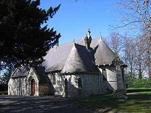
Tully Church is an ancient church in County Dublin, Ireland.

Shankill railway station (DW&WR)
Railway station in Ireland
Distance: Approx. 1238 meters
Latitude and longitude: 53.234,-6.127
Shankill railway station was a station on the Harcourt Street railway line. It served the suburb of Shankill, in County Dublin, Ireland.

Brides Glen Luas stop
Tram stop in Dublin, Ireland
Distance: Approx. 196 meters
Latitude and longitude: 53.24210932,-6.14284772
Brides Glen (Irish: Gleann Bhríde) is a stop on the Luas light-rail tram system serving Cherrywood in Dún Laoghaire–Rathdown, County Dublin, Ireland. It opened in 2010 as the terminus of an extension of the Green Line south from Sandyford.

Cherrywood Luas stop
Tram stop in Dublin, Ireland
Distance: Approx. 543 meters
Latitude and longitude: 53.2453546,-6.14583692
Cherrywood (Irish: Coill na Silíní) is a stop on the Luas light-rail tram system serving Cherrywood in Dún Laoghaire–Rathdown, County Dublin, Ireland. It opened in 2010 as a stop on the extension of the Green Line south from Sandyford to Brides Glen.

Laughanstown Luas stop
Tram stop in Dublin, Ireland
Distance: Approx. 1390 meters
Latitude and longitude: 53.25061238,-6.15501545
Laughanstown (Irish: Baile an Locháin) is a stop on the green line of the Luas light-rail tram system in Dún Laoghaire–Rathdown, County Dublin, Ireland. The stop provides access to the nearby suburb of Cabinteely.

Puck's Castle
Historic site in County Dublin, Ireland
Distance: Approx. 1584 meters
Latitude and longitude: 53.230939,-6.15487
Puck's Castle (Irish: Caisleán an Phúca) is a castle ruin in Rathmichael, County Dublin, Ireland. The castle is thought to have been erected by Peter Talbot in 1537, along with nearby castles on the Pale, to defend from the incursions of the O'Toole clan. The name 'Puck's Castle' is derived from the Celtic folklore spirit the 'Púca', which lends itself to local legend that the castle is haunted.
Weather in this IP's area
moderate rain
6 Celsius
5 Celsius
5 Celsius
7 Celsius
1007 hPa
94 %
1007 hPa
1001 hPa
4285 meters
1.34 m/s
3.58 m/s
109 degree
100 %
07:55:22
16:24:32