Country:
Region:
City:
Latitude and Longitude:
Time Zone:
Postal Code:
IP information under different IP Channel
ip-api
Country
Region
City
ASN
Time Zone
ISP
Blacklist
Proxy
Latitude
Longitude
Postal
Route
Luminati
Country
Region
81
City
brovst
ASN
Time Zone
Europe/Copenhagen
ISP
Norlys Digital A/S
Latitude
Longitude
Postal
IPinfo
Country
Region
City
ASN
Time Zone
ISP
Blacklist
Proxy
Latitude
Longitude
Postal
Route
db-ip
Country
Region
City
ASN
Time Zone
ISP
Blacklist
Proxy
Latitude
Longitude
Postal
Route
ipdata
Country
Region
City
ASN
Time Zone
ISP
Blacklist
Proxy
Latitude
Longitude
Postal
Route
Popular places and events near this IP address

Brønderslev
City in North Jutland Region, Denmark
Distance: Approx. 580 meters
Latitude and longitude: 57.26944444,9.94722222
Brønderslev is a city in Denmark with a population of 12,842 (1 January 2024). The city is the largest urban area in Brønderslev Municipality and is the municipal seat. It is the fourth largest city of Vendsyssel within the North Jutland Region.
Vendsyssel
District of North Jutland, Denmark
Distance: Approx. 6362 meters
Latitude and longitude: 57.28777778,10.04555556
Vendsyssel (Danish pronunciation: [ˈvenˌsysl̩]) is the northernmost traditional district of Denmark and of Jutland. Being divided from mainland Jutland by the Limfjord, it is technically a part of the North Jutlandic Island which also comprises the areas Hanherred and Thy. Vendsyssel is part of the North Denmark Region.
Brønderslev Municipality
Municipality in North Jutland, Denmark
Distance: Approx. 669 meters
Latitude and longitude: 57.2683,9.9458
Brønderslev Municipality (Danish: Brønderslev Kommune) is a municipality (Danish, kommune) in North Jutland Region in Denmark. It covers an area of 630 km2 and has a total population of 36,614 (2024). The municipal council is located in the town of Brønderslev.
Vrå
Town in North Jutland Region, Denmark
Distance: Approx. 8975 meters
Latitude and longitude: 57.35472222,9.94194444
Vrå is a railway town in Hjørring municipality, Denmark. It was the former municipal seat of the abolished Løkken-Vrå municipality. As of 1 January 2024, Vrå has a population of 2,592.
Tylstrup
Town in North Jutland Region, Denmark
Distance: Approx. 8882 meters
Latitude and longitude: 57.19444444,9.95138889
Tylstrup is a railway town at the Vendsyssel railway line. It is located some 18 km (11 mi) north of Aalborg's city centre and belongs to the Municipality of Aalborg in the North Jutland Region in Denmark Tylstrup has a population of 1,237 (1 January 2024).

Hasseris
Area of Aalborg, Denmark
Distance: Approx. 8882 meters
Latitude and longitude: 57.19444444,9.95138889
Hasseris is a district of the city of Aalborg and a former municipality in the northeast of Denmark. It is located some 3 km (1.9 mi) southwest of the city centre. As of 2016, Hasseris had 11,685 inhabitants.
Vrå railway station
Railway station in North Jutland, Denmark
Distance: Approx. 8944 meters
Latitude and longitude: 57.35444444,9.9425
Vrå railway station is a railway station serving the railway town of Vrå in Vendsyssel, Denmark. The station is located on the Vendsyssel Line from Aalborg to Frederikshavn, between Hjørring station and Brønderslev station. It opened in 1871.

Brønderslev railway station
Railway station in North Jutland, Denmark
Distance: Approx. 421 meters
Latitude and longitude: 57.27031667,9.94271111
Brønderslev railway station (Danish: Brønderslev Station or Brønderslev Banegård) is a railway station serving the town of Brønderslev in Vendsyssel, Denmark. The station is located on the Vendsyssel Line from Aalborg to Frederikshavn. It opened in 1871 and was moved to its current location in 1966.
Gammel Vraa Castle
Distance: Approx. 8989 meters
Latitude and longitude: 57.1939,9.9255
Gammel Vraa is a former manor house located in the town of Tylstrup in North Jutland, Denmark. It lies between forest and fields around 16 km from Aalborg. The nearest small towns are Sulsted and Tylstrup, which lies 3–4 km distance.

Brønderslev Gymnasium og HF
Danish secondary school
Distance: Approx. 513 meters
Latitude and longitude: 57.2787,9.9425
Brønderslev Gymnasium og HF-kursus is secondary school in Brønderslev, Denmark. The school offers gymnasium and Higher Preparatory Examination programs and has a student body of around 550. The gymnasium was first proposed by the Brønderslev city council in 1958, though students were not admitted until 1973.
Brønderslev Church
Church in Brønderslev, Denmark
Distance: Approx. 891 meters
Latitude and longitude: 57.26830556,9.95311111
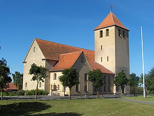
Brønderslev Church (Danish: Brønderslev Kirke) is a Lutheran church in Brønderslev, Denmark. The church was designed by Valdemar Schmidt and built between 1920 and 1922.
Weather in this IP's area
scattered clouds
-4 Celsius
-8 Celsius
-4 Celsius
-4 Celsius
991 hPa
79 %
991 hPa
989 hPa
10000 meters
2.88 m/s
4.53 m/s
17 degree
34 %
08:12:17
15:59:24


