Country:
 Germany
Region:
City:
Latitude and Longitude:
Time Zone:
Postal Code:
IP information under different IP Channel
ip-api
Country
Region
City
ASN
Time Zone
ISP
Blacklist
Proxy
Latitude
Longitude
Postal
Route
IPinfo
Country
Region
City
ASN
Time Zone
ISP
Blacklist
Proxy
Latitude
Longitude
Postal
Route
MaxMind
Country
Region
City
ASN
Time Zone
ISP
Blacklist
Proxy
Latitude
Longitude
Postal
Route
Luminati
Country
DEASN
Time Zone
Europe/Berlin
ISP
Andreas Otto
Latitude
Longitude
Postal
db-ip
Country
Region
City
ASN
Time Zone
ISP
Blacklist
Proxy
Latitude
Longitude
Postal
Route
ipdata
Country
Region
City
ASN
Time Zone
ISP
Blacklist
Proxy
Latitude
Longitude
Postal
Route
Popular places and events near this IP address
Fernmeldeturm Nürnberg
Telecommunication tower in Bavaria, Germany
Distance: Approx. 1829 meters
Latitude and longitude: 49.42611111,11.03888889
The Fernmeldeturm Nürnberg, the tallest structure in Bavaria, is a telecommunication tower in Nuremberg, southern Germany. Also called the Nürnberger Ei ("Egg of Nuremberg") because of its egg-shaped tower basket in a height of 185 metres, it is 292 metres high and was built between 1977 and 1980 according to blueprints by architect Erwin Heinle. The tower basket accommodates transmission mechanisms for Frequency modulation, DAB, UMTS, pager, amateur radio and a microwave radio relay link and – closed since 1991 – a rotating restaurant and a prospect platform.
Nuremberg-Kleinreuth radio transmitter
Former broadcasting facility
Distance: Approx. 2325 meters
Latitude and longitude: 49.44388889,11.00861111
The Transmitter Nuremberg-Kleinreuth was a broadcasting facility for medium wave at Nuremberg, Bavaria, Germany. It was founded in 1927 in Nuremberg-Kleinreuth at the former Broadcast Street 24, now Sigmund Street 181, in order to supply the northern areas of Bavaria with broadcast programs in the medium-wave band.
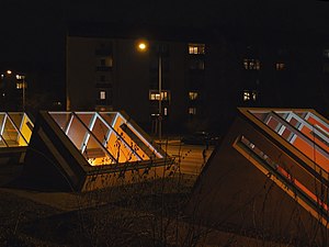
Sündersbühl station
Metro station in Nuremberg, Germany
Distance: Approx. 2989 meters
Latitude and longitude: 49.4418315,11.0438853
Sündersbühl station is a Nuremberg U-Bahn station, located on the U3.
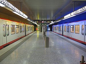
Gustav-Adolf-Straße station
Metro station in Nuremberg, Germany
Distance: Approx. 2428 meters
Latitude and longitude: 49.4390413,11.0372095
Gustav-Adolf-Straße station is a Nuremberg U-Bahn station, located on the U3. The station is named for the Swedish king Gustavus Adolphus.

Schweinau station
Metro station in Nuremberg, Germany
Distance: Approx. 2761 meters
Latitude and longitude: 49.4342383,11.0482244
Schweinau station is a Nuremberg U-Bahn station, located on the U2.
Röthenbach station
Metro station in Nuremberg, Germany
Distance: Approx. 1312 meters
Latitude and longitude: 49.4208722,11.0317311
Röthenbach station is a Nuremberg U-Bahn station and is the terminus of the U2 line.

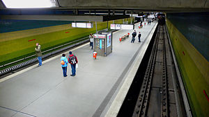
Hohe Marter station
Metro station in Nuremberg, Germany
Distance: Approx. 2239 meters
Latitude and longitude: 49.4287483,11.0437671
Hohe Marter station is a Nuremberg U-Bahn station, located on the line U2. Opened in 1986, Hohe Marter is a U-Bahn station, designed by the artist Peter Angermann. It has a pixel graphical tile mosaic of the horizontally positioned broadcasting tower on its sides.

Stein, Bavaria
Town in Bavaria, Germany
Distance: Approx. 763 meters
Latitude and longitude: 49.41666667,11.01666667
Stein (East Franconian: Schdah) is a town in the district of Fürth, in Bavaria, Germany. It is situated 7 km south of Fürth, and 7 km southwest of Nuremberg (centre).
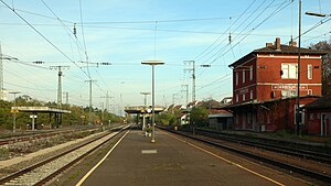
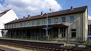
Nürnberg-Stein station
Railway halt in Nuremberg, Germany
Distance: Approx. 366 meters
Latitude and longitude: 49.42541889,11.01787194
Nürnberg-Stein station is a railway station in Nuremberg, Bavaria, Germany. It is served by the Nuremberg suburban train line S4. The station is on the Nuremberg–Crailsheim line of Deutsche Bahn.
Unterasbach station
Railway station in Fürth, Germany
Distance: Approx. 2149 meters
Latitude and longitude: 49.41666111,10.98613889
Unterasbach station is a railway station in the municipality of Oberasbach, located in the Fürth district in Bavaria, Germany. The station is on the Nuremberg–Crailsheim line of Deutsche Bahn.
Nürnberg-Schweinau station
Railway station in Nuremberg, Germany
Distance: Approx. 2575 meters
Latitude and longitude: 49.43429389,11.04528694
Nürnberg-Schweinau station is a railway station in the Schweinau district of Nürnberg, Franconia, Germany. The station is on the Nuremberg–Crailsheim line of Deutsche Bahn.
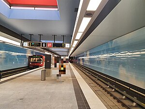
Großreuth bei Schweinau station
Metro station in Nuremberg, Germany
Distance: Approx. 1933 meters
Latitude and longitude: 49.439306,11.024337
Großreuth bei Schweinau station is a Nuremberg U-Bahn station, located on the U3. Named for the borough Großreuth bei Schweinau. The distance to the previous station, Gustav Adolf Straße is 898 metres (2,946 ft) as the crow flies.
Weather in this IP's area
drizzle
9 Celsius
9 Celsius
9 Celsius
10 Celsius
1021 hPa
88 %
1021 hPa
983 hPa
4300 meters
1.03 m/s
100 %
07:37:14
18:25:44