185.49.227.196 - IP Lookup: Free IP Address Lookup, Postal Code Lookup, IP Location Lookup, IP ASN, Public IP
Country:
Region:
City:
Location:
Time Zone:
Postal Code:
IP information under different IP Channel
ip-api
Country
Region
City
ASN
Time Zone
ISP
Blacklist
Proxy
Latitude
Longitude
Postal
Route
Luminati
Country
ASN
Time Zone
Europe/Madrid
ISP
Invermae Solutions SL
Latitude
Longitude
Postal
IPinfo
Country
Region
City
ASN
Time Zone
ISP
Blacklist
Proxy
Latitude
Longitude
Postal
Route
IP2Location
185.49.227.196Country
Region
madrid, comunidad de
City
madrid
Time Zone
Europe/Madrid
ISP
Language
User-Agent
Latitude
Longitude
Postal
db-ip
Country
Region
City
ASN
Time Zone
ISP
Blacklist
Proxy
Latitude
Longitude
Postal
Route
ipdata
Country
Region
City
ASN
Time Zone
ISP
Blacklist
Proxy
Latitude
Longitude
Postal
Route
Popular places and events near this IP address

Parque del Buen Retiro, Madrid
Urban park n Madrid, Spain
Distance: Approx. 212 meters
Latitude and longitude: 40.415,-3.68388889
The Retiro Park (Spanish: Parque del Buen Retiro, literally "Good Retreat Park"), also known as Buen Retiro Park or simply El Retiro, is one of the largest city parks in Madrid, Spain. The park belonged to the Spanish monarchy until 1868, when it became a public park following the Glorious Revolution. The park is located at the edge of the city centre, near both the Puerta de Alcalá and the Museo del Prado, and covers 1.4 km2 (350 acres).

Buen Retiro Palace
Distance: Approx. 431 meters
Latitude and longitude: 40.413675,-3.68168889
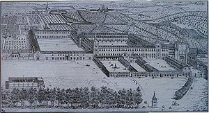
Buen Retiro Palace (Spanish: Palacio del Buen Retiro) in Madrid was a large palace complex designed by the architect Alonso Carbonell (c. 1590–1660) and built on the orders of Philip IV of Spain as a secondary residence and place of recreation (hence its name). It was built in what was then the eastern limits of the city of Madrid.

Palacio de Cristal del Retiro
Glass building in Madrid, Spain
Distance: Approx. 425 meters
Latitude and longitude: 40.41355556,-3.68205556
The Palacio de Cristal ("Glass Palace") is a 19th-century conservatory located in the Buen Retiro Park in Madrid, Spain. It is currently used for art exhibitions. The Palacio de Cristal, in the shape of a Greek cross, is made almost entirely of glass set in an iron framework on a brick base, which is decorated with ceramics.

Church of Saint Manuel and Saint Benedict
Historic site in Madrid, Spain
Distance: Approx. 460 meters
Latitude and longitude: 40.420794,-3.6861
Saint Manuel and Saint Benedict (Spanish: San Manuel y San Benito) is a Catholic church located in Madrid, Spain. The building, which was designed by Fernando Arbós y Tremanti, was built at the beginning of the twentieth century. It was declared Bien de Interés Cultural in 1982.

Monument to Alfonso XII
Monument by José Grases Riera in Madrid, Spain
Distance: Approx. 151 meters
Latitude and longitude: 40.41733,-3.68306
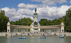
The Monument to Alfonso XII (Spanish: Monumento a Alfonso XII) is located in Buen Retiro Park (El Retiro), Madrid, Spain. The monument is situated on the east edge of an artificial lake near the center of the park. In 1902, a national contest was held to design a monument for King Alfonso XII at the initiative of the Queen Mother Maria Christina of Austria.

Palacio de Velázquez
Distance: Approx. 291 meters
Latitude and longitude: 40.41518889,-3.68198889
Palacio de Velázquez, or Velázquez Palace (sometimes referred to as Palacio de Exposiciones) is an exhibition hall located in Buen Retiro Park, Madrid, Spain. Originally known as the Palacio de la Minería, it was built in 1881-3 for the Exposición Nacional de Minería by architect Ricardo Velázquez Bosco (and named after him), engineer Alberto Palacio, and ceramist Daniel Zuloaga. It functions as an arts and crafts gallery and is listed as a Bien de Interés Cultural.

Museo Nacional de Artes Decorativas
Decorative arts museum in Madrid, Spain
Distance: Approx. 451 meters
Latitude and longitude: 40.41791194,-3.68981694
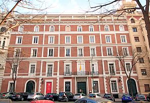
The National Museum of Decorative Arts (Spanish: Museo Nacional de Artes Decorativas; originally, National Museum of Industrial Arts) is a decorative arts museum in Madrid, Spain, devoted to the industrial or "minor arts", including furniture, ceramics, glass, and textiles. It is one of the National Museums of Spain and it is attached to the Ministry of Culture. It is one of the oldest museums in the city, situated within the Golden Triangle of Art, at the south of the Puerta de Alcalá and the western side of the Buen Retiro Park.

Retiro (Madrid Metro)
Madrid Metro station
Distance: Approx. 411 meters
Latitude and longitude: 40.4203029,-3.6862484
Retiro [reˈtiɾo] is a metro station which serves the Retiro District and Buen Retiro Park in Madrid, Spain.

Plaza de la Independencia (Madrid)
Distance: Approx. 487 meters
Latitude and longitude: 40.42,-3.68861111
The Plaza de la Independencia (Independence Square) is a central square in the Spanish capital, Madrid. It sits at the intersection of Calle de Alcalá (running from east to west), Calle de Alfonso XII (to the south), Calle de Serrano (to the north), Calle de Salustiano Olozaga (to the northwest), and the Paseo de Mexico (to the southeast, running entirely within the Buen Retiro Park). Being centred with the 18th-century gate of Puerta de Alcalá, the Plaza de la Independencia is among the important symbols of the city of Madrid.

Centro de Investigaciones Sociológicas
Spanish research institute (founded 1963)
Distance: Approx. 490 meters
Latitude and longitude: 40.4179,-3.6903
The Centro de Investigaciones Sociológicas (Centre for Sociological Research), or CIS, is a Spanish public research institute.

Monument to General Martínez Campos
Monument in Madrid
Distance: Approx. 338 meters
Latitude and longitude: 40.417806,-3.680936
The Monument to General Martínez Campos is an instance of public art in Madrid, Spain. Designed by Mariano Benlliure, it consists of an sculptural ensemble presided by an equestrian statue of General Arsenio Martínez Campos, who played a key role in bringing the Bourbon Restoration by leading the coup d'etat of Sagunto in 1874. It lies on the centre of the Plaza de Guatemala, in El Retiro.

Monument to Cuba (Madrid)
Monument in Madrid
Distance: Approx. 338 meters
Latitude and longitude: 40.417806,-3.680936
The Monument to Cuba is an instance of public art in Madrid, Spain, consisting of a fountain over which an sculptural group topped by an allegory of Cuba emerges from. It is located at El Retiro Park.
Weather in this IP's area
overcast clouds
6 Celsius
4 Celsius
4 Celsius
7 Celsius
1030 hPa
86 %
1030 hPa
953 hPa
10000 meters
1.79 m/s
3.58 m/s
67 degree
100 %