185.47.86.244 - IP Lookup: Free IP Address Lookup, Postal Code Lookup, IP Location Lookup, IP ASN, Public IP
Country:
Region:
City:
Location:
Time Zone:
Postal Code:
ISP:
ASN:
language:
User-Agent:
Proxy IP:
Blacklist:
IP information under different IP Channel
ip-api
Country
Region
City
ASN
Time Zone
ISP
Blacklist
Proxy
Latitude
Longitude
Postal
Route
db-ip
Country
Region
City
ASN
Time Zone
ISP
Blacklist
Proxy
Latitude
Longitude
Postal
Route
IPinfo
Country
Region
City
ASN
Time Zone
ISP
Blacklist
Proxy
Latitude
Longitude
Postal
Route
IP2Location
185.47.86.244Country
Region
new jersey
City
middletown
Time Zone
America/New_York
ISP
Language
User-Agent
Latitude
Longitude
Postal
ipdata
Country
Region
City
ASN
Time Zone
ISP
Blacklist
Proxy
Latitude
Longitude
Postal
Route
Popular places and events near this IP address

Middletown Township, New Jersey
Township in Monmouth County, New Jersey, US
Distance: Approx. 1894 meters
Latitude and longitude: 40.404786,-74.071404
Middletown Township is a township in northern Monmouth County, in the U.S. state of New Jersey. As of the 2020 United States census, the township was the state's 20th-most-populous municipality and the largest in the county, with a population of 67,106, an increase of 584 (+0.9%) from the 2010 census count of 66,522, which in turn reflected an increase of 195 residents (0.3%) from its population of 66,327 at the 2000 census, when it was the state's 17th-most-populous municipality. Middletown is a bedroom community of New York City, located alongside of the Raritan Bay within the Raritan Valley region in the New York metropolitan area.

Evil Clown of Middletown
Monument in Middletown, New Jersey
Distance: Approx. 895 meters
Latitude and longitude: 40.3917,-74.0991
The Evil Clown of Middletown is a large outdoor sign in Middletown Township, New Jersey. Originally built by and for Food Circus grocery store, which later became known as the regional supermarket Foodtown, it is now a roadside display and de facto advertising sign for a nearby Spirits Liquors. Much of the clown's notoriety stems from its sinister-looking face, which might be described as bearing a vaguely amused sideways scowl.
Middletown Township Public School District
School district in Monmouth County, New Jersey, US
Distance: Approx. 3242 meters
Latitude and longitude: 40.41297,-74.059242
The Middletown Township Public School District is a comprehensive community public school district that serves students from pre-kindergarten through twelfth grade from Middletown Township in Monmouth County, in the U.S. state of New Jersey. As of the 2021–22 school year, the district, comprising 16 schools, had an enrollment of 9,150 students and 794.3 classroom teachers (on an FTE basis), for a student–teacher ratio of 11.5:1. The district is classified by the New Jersey Department of Education as being in District Factor Group "GH", the third-highest of eight groupings.
Middletown High School North
High school in Monmouth County, New Jersey, US
Distance: Approx. 902 meters
Latitude and longitude: 40.401574,-74.10036
Middletown High School North, home of the Lions, is a four-year comprehensive public high school located in Middletown Township, in Monmouth County, in the U.S. state of New Jersey, serving students in ninth through twelfth grades as one of the two secondary schools of the Middletown Township Public School District. Other students from Middletown Township attend Middletown High School South. The school also houses a 750-seat theater.

Mater Dei High School (New Jersey)
Catholic school in Monmouth County, New Jersey, US
Distance: Approx. 2269 meters
Latitude and longitude: 40.4151,-74.1042
Mater Dei Prep: A Catholic Preparatory School (commonly known as "Mater Dei High School") was a four-year Catholic coeducational high school that served students in ninth through twelfth grades, located in the New Monmouth section of Middletown Township, in Monmouth County, in the U.S. state of New Jersey.

Middletown station (NJ Transit)
NJ Transit rail station
Distance: Approx. 2237 meters
Latitude and longitude: 40.38939167,-74.11570556
Middletown is a passenger railway station for New Jersey Transit's North Jersey Coast Line in Middletown Township, Monmouth County, New Jersey. Located along both sides of Church Street in Middletown, the station is the only active station within the township.

New Monmouth, New Jersey
Populated place in Monmouth County, New Jersey, US
Distance: Approx. 1928 meters
Latitude and longitude: 40.41194444,-74.10333333
New Monmouth is an unincorporated community located within Middletown Township in Monmouth County, in the U.S. state of New Jersey. The area is served as United States Postal Service ZIP Code 07748. As of the 2010 United States Census, the population for ZIP Code Tabulation Area 07748 was 28,030.
Chapel Hill Rear Range Light
Lighthouse
Distance: Approx. 2775 meters
Latitude and longitude: 40.3983,-74.0587
The Chapel Hill Rear Range Light is a lighthouse located off of Middletown Township in Monmouth County, New Jersey, United States, which functioned as the rear light of the now-discontinued Chapel Hill Range.

Christ Church (Middletown, New Jersey)
Historic church in New Jersey, United States
Distance: Approx. 2266 meters
Latitude and longitude: 40.39388889,-74.11777778
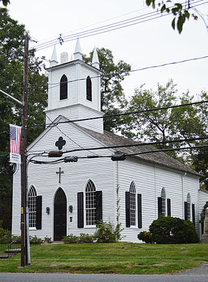
Christ Church is a historic church in Middletown Township, New Jersey built in 1744.
Mount Olivet Cemetery (Middletown, New Jersey)
Cemetery in Monmouth County, New Jersey, US
Distance: Approx. 2487 meters
Latitude and longitude: 40.37579,-74.08302
Mount Olivet Cemetery is a cemetery in Middletown, New Jersey.

Chapel Hill, New Jersey
Populated place in Monmouth County, New Jersey, US
Distance: Approx. 1767 meters
Latitude and longitude: 40.39722222,-74.07055556
Chapel Hill is an unincorporated community located within Middletown Township, in Monmouth County, in the U.S. state of New Jersey. As its name implies, the area is on a high spot within the township between Fairview and Leonardo just south of the Naval Weapons Station Earle Waterfront Section. Unlike other areas of Middletown Township, the Chapel Hill section is not as developed with single-family homes; only a few housing developments are located off the area's main roads, Kings Highway and Chapel Hill Road.
Middletown Village, New Jersey
Populated place in Monmouth County, New Jersey, US
Distance: Approx. 2215 meters
Latitude and longitude: 40.39416667,-74.11722222
Middletown Village is an unincorporated community located in the central part of Middletown Township, Monmouth County, New Jersey. It was the first settlement in the township and one of the oldest in New Jersey. The Middletown Village Historic District, encompassing the community, was listed on the state and national registers of historic places in 1974.
Weather in this IP's area
clear sky
-1 Celsius
-5 Celsius
-2 Celsius
-0 Celsius
1018 hPa
43 %
1018 hPa
1016 hPa
10000 meters
3.58 m/s
8.94 m/s
295 degree
2 %
