Country:
 Netherlands
Region:
City:
Latitude and Longitude:
Time Zone:
Postal Code:
IP information under different IP Channel
ip-api
Country
Region
City
ASN
Time Zone
ISP
Blacklist
Proxy
Latitude
Longitude
Postal
Route
IPinfo
Country
Region
City
ASN
Time Zone
ISP
Blacklist
Proxy
Latitude
Longitude
Postal
Route
MaxMind
Country
Region
City
ASN
Time Zone
ISP
Blacklist
Proxy
Latitude
Longitude
Postal
Route
Luminati
Country
NLRegion
zh
City
rotterdam
ASN
Time Zone
Europe/Amsterdam
ISP
IP Visie Networking B.V.
Latitude
Longitude
Postal
db-ip
Country
Region
City
ASN
Time Zone
ISP
Blacklist
Proxy
Latitude
Longitude
Postal
Route
ipdata
Country
Region
City
ASN
Time Zone
ISP
Blacklist
Proxy
Latitude
Longitude
Postal
Route
Popular places and events near this IP address

Rotterdam The Hague Airport
Airport in Zestienhoven, Rotterdam, the Netherlands
Distance: Approx. 1017 meters
Latitude and longitude: 51.95694444,4.44027778
Rotterdam The Hague Airport (formerly Rotterdam Airport, Vliegveld Zestienhoven in Dutch), (IATA: RTM, ICAO: EHRD) is a minor international airport serving Rotterdam, the Netherlands' second largest city, and The Hague, its administrative and royal capital. It is located 5.5 kilometres (3.4 mi; 3.0 nmi) north northwest of Rotterdam in South Holland and is the third busiest airport in the Netherlands. The airport handled over 2.1 million passengers in 2019 and features scheduled flights to European metropolitan and leisure destinations.
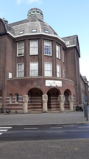
Islamic University of Applied Sciences Rotterdam
Islamic universities in Netherlands
Distance: Approx. 2124 meters
Latitude and longitude: 51.9352,4.4694
The Islamic University of Applied Sciences Rotterdam (IUASR; Dutch: Islamitische Universiteit Rotterdam) is a vocational university founded in 1997. It is a member of the Federation of the Universities of the Islamic World. The Islamic University of Applied Sciences Rotterdam received her first accreditation in 2010 for her master's degree programme Islamic Spiritual Care (Chaplaincy) and in 2013 for Bachelor program Islamic Theology; both degree programmes are accredited by the NVAO (the official accreditation organisation of the Netherlands and Flanders).

Overschie
Distance: Approx. 2109 meters
Latitude and longitude: 51.93333333,4.43333333
Overschie is a neighborhood of Rotterdam, Netherlands, formerly a separate village with its own municipality. The village of Overschie was located on the intersection of four rivers called "Schie": the Delftsche Schie, Schiedamsche Schie, Delfshavensche Schie, and Rotterdamsche Schie. It was a separate municipality between 1817 and 1941, when it merged with Rotterdam.

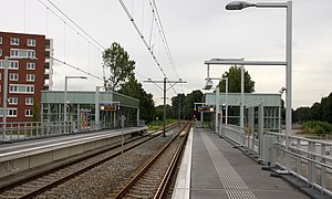
Melanchthonweg RandstadRail station
Metro station in Rotterdam, Netherlands
Distance: Approx. 1059 meters
Latitude and longitude: 51.94861111,4.46444444
Melanchthonweg is a metro station, as a part of the Rotterdam metro and the regional light rail system RandstadRail, located in Rotterdam, the Netherlands.

Blijdorp RandstadRail station
Metro station in Rotterdam, Netherlands
Distance: Approx. 2172 meters
Latitude and longitude: 51.93083333,4.45777778
Blijdorp is a metro station, as a part of the Rotterdam metro and the regional light rail system RandstadRail, located in Rotterdam-Blijdorp, the Netherlands. The station was opened on 17 August 2010, together with the tunnel connecting the metro station of Rotterdam Centraal to the Hofpleinlijn, which is part of the RandstadRail project. Since the station opened, line E trains run from Rotterdam Centraal towards Den Haag Centraal.
Meijersplein / Airport RandstadRail station
Metro station in Rotterdam, Netherlands
Distance: Approx. 1156 meters
Latitude and longitude: 51.95611111,4.46222222
Meijersplein / Airport is a metro station, as a part of the Rotterdam metro and the regional light rail system RandstadRail, located in Schiebroek, a borough of Rotterdam, the Netherlands.

Bergpolderflat
Distance: Approx. 2001 meters
Latitude and longitude: 51.935,4.4661
The Bergpolderflat in the Rotterdam district Bergpolder (corner of Abraham Kuyperlaan and Borgesiusstraat) was the first gallery flat in the Netherlands . The flat has a steel skeleton and was designed in 1933/1934 by the architect W. de Tijen in collaboration with architects Brinkman and Van der Vlugt in the Modern style, functional, sleek, light and airy. The apartment was built by NV Volkswoningbouw Rotterdam.

Bergpolder
Neighborhood of Rotterdam in South Holland, Netherlands
Distance: Approx. 1963 meters
Latitude and longitude: 51.93555556,4.46638889
Bergpolder is a neighborhood of Rotterdam, Netherlands in Rotterdam-Noord. Since November 5, 2014, the district is part of the protected historic area "Rijksbeschermd gezicht Blijdorp/Bergpolder". Bergpolder has 8,205 inhabitants (as of 2021) with a large number of different nationalities.
Kleinpolder
Neighborhood of Rotterdam in South Holland, Netherlands
Distance: Approx. 2184 meters
Latitude and longitude: 51.93416667,4.42944444
Kleinpolder (Dutch pronunciation: [klɛimˈpɔldər]) is a neighborhood of Rotterdam, Netherlands.

Zestienhoven (district)
Neighborhood of Rotterdam in South Holland, Netherlands
Distance: Approx. 1154 meters
Latitude and longitude: 51.95694444,4.43722222
Zestienhoven is a neighborhood of Rotterdam, Netherlands and is part of the borough Overschie. Zestienhoven is the largest district in Overschie, but is sparsely populated. The Polder Zestienhoven is within the district, east of the urban area of Overschie.
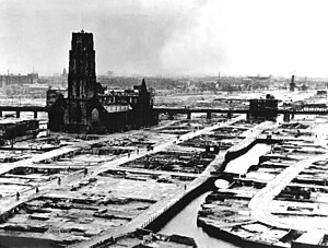
German bombing of Rotterdam
WWII aerial bombardment of Rotterdam by Nazi Germany
Distance: Approx. 1657 meters
Latitude and longitude: 51.96443056,4.45123611
In 1940, Rotterdam was subjected to heavy aerial bombardment by the Luftwaffe during the German invasion of the Netherlands during the Second World War. The objective was to support the German troops fighting in the city, break Dutch resistance and force the Dutch army to surrender. Bombing began at the outset of hostilities on 10 May and culminated with the destruction of the entire historic city centre on 14 May, an event sometimes referred to as the Rotterdam Blitz.
Sportpark Laag Zestienhoven
Distance: Approx. 1430 meters
Latitude and longitude: 51.93736111,4.45542222
Sportpark Laag Zestienhoven is a cricket ground in Rotterdam, the Netherlands. The first recorded match on the ground came in 1963 when RG Inglese's XI played The Forty Club. The ground later held six matches in the 1990 ICC Trophy.
Weather in this IP's area
overcast clouds
20 Celsius
20 Celsius
19 Celsius
21 Celsius
1006 hPa
67 %
1006 hPa
1006 hPa
10000 meters
4.12 m/s
190 degree
90 %
07:06:04
20:13:53