Country:
 Netherlands
Region:
City:
Latitude and Longitude:
Time Zone:
Postal Code:
IP information under different IP Channel
ip-api
Country
Region
City
ASN
Time Zone
ISP
Blacklist
Proxy
Latitude
Longitude
Postal
Route
IPinfo
Country
Region
City
ASN
Time Zone
ISP
Blacklist
Proxy
Latitude
Longitude
Postal
Route
MaxMind
Country
Region
City
ASN
Time Zone
ISP
Blacklist
Proxy
Latitude
Longitude
Postal
Route
Luminati
Country
NLRegion
zh
City
rotterdam
ASN
Time Zone
Europe/Amsterdam
ISP
IP Visie Networking B.V.
Latitude
Longitude
Postal
db-ip
Country
Region
City
ASN
Time Zone
ISP
Blacklist
Proxy
Latitude
Longitude
Postal
Route
ipdata
Country
Region
City
ASN
Time Zone
ISP
Blacklist
Proxy
Latitude
Longitude
Postal
Route
Popular places and events near this IP address

Montevideo (Rotterdam)
43-storey, 139.5 m (458 ft) residential skyscraper in Rotterdam, The Netherlands
Distance: Approx. 684 meters
Latitude and longitude: 51.90361,4.48556
Montevideo is a 43-storey, 139.5 m (458 ft) residential skyscraper on the river Nieuwe Maas in Rotterdam, The Netherlands. The Montevideo logo on the roof is an 8 by 8 m (26 by 26 ft) letter "M" which brings the tower's total height to 152.3 m (500 ft). The logo is also designed to be a giant wind vane.
Katendrecht
Distance: Approx. 774 meters
Latitude and longitude: 51.9,4.48333333
Katendrecht is a neighbourhood of Rotterdam, on the south bank of the Nieuwe Maas. It is located between the Rijnhaven and the Maashaven. Katendrecht was a separate municipality from 1817 to 1874, when it merged with Charlois.
Eneco
Utility company in the Netherlands
Distance: Approx. 775 meters
Latitude and longitude: 51.90555556,4.48611111
Eneco, the trading name of Eneco Groep N.V., is a producer and supplier of natural gas, electricity and heat in the Netherlands, serving more than 2 million business and residential customers. Eneco headquarters are located in Rotterdam. It also carries out energy trading and is involved in sustainable energy projects.

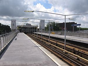
Maashaven metro station
Metro station in Rotterdam, Netherlands
Distance: Approx. 410 meters
Latitude and longitude: 51.89722222,4.49472222
Maashaven is an above-ground metro station in the south of the city of Rotterdam. It is part of Rotterdam Metro lines D and E. The station opened on 9 February 1968, the same date that the North-South Line (also formerly called Erasmus line), of which it is a part, was opened. Maashaven station is located just east of a harbor with the same name.
Rijnhaven metro station
Subway station in Rotterdam, Netherlands
Distance: Approx. 373 meters
Latitude and longitude: 51.90388889,4.49694444
Rijnhaven is an above-ground subway station in the south of the city of Rotterdam. It is part of Rotterdam Metro lines D and E. The station opened on 9 February 1968, the same date that the North-South Line (also formerly called Erasmus line), of which it is a part, was opened. Near the station, travelers can get on RET-operated bus line 77 which can bring them to the SS Rotterdam.

Wilhelminaplein metro station
Metro station in Rotterdam, Netherlands
Distance: Approx. 705 meters
Latitude and longitude: 51.90722222,4.49388889
Wilhelminaplein is an underground subway station in Rotterdam, Netherlands, which lies south of the Maas river. It is part of Rotterdam Metro lines D and E. Wilhelminaplein station was opened in 1997 as a new infill station of the North-South Line, which itself was already opened in 1968. Because the station was constructed at the location where the metro tunnel is going up on its way to the surface, the platforms, like the rest of the station, are not entirely horizontal.
Afrikaanderplein
Distance: Approx. 466 meters
Latitude and longitude: 51.899954,4.50111
Afrikaanderplein was a football ground in Rotterdam, the Netherlands. It was the first home of the professional football club Feyenoord – then known as Wilhelmina (1908–09), HFC (1909), Celeritas (1909–12) and eventually Feijenoord – from its foundation in 1908 until 1917, when the club moved to a new ground at the Kromme Zandweg. Before the foundation of Feyenoord, fellow Rotterdam club Excelsior played its matches on the Afrikaanderplein in the season 1907–08, after which the club returned to Woudestein.
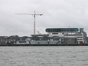
Rotterdam Cruise Terminal
Cruise ship terminal in Rotterdam
Distance: Approx. 769 meters
Latitude and longitude: 51.90583333,4.48666667
The Rotterdam Cruise Terminal is a building on the Wilhelmina Pier, Rotterdam. The Cruise Terminal served as the arrival and departure point of Holland America Line and is considered part of the city’s social and industrial heritage. The Cruise Terminal is still used by large passenger vessels that visit Rotterdam.

Afrikaanderwijk
Neighborhood of Rotterdam in South Holland, Netherlands
Distance: Approx. 502 meters
Latitude and longitude: 51.9,4.50166667
Afrikaanderwijk is a neighborhood of Rotterdam, Netherlands. It lies in the Feijenoord district of the city, and is traditionally a working-class neighborhood. The neighborhood was one of the first in the Netherlands to have a majority of residents with a foreign background, primarily consisting of Turks, Moroccans, Surinamese, and Antilleans.

Kop van Zuid
Neighborhood of Rotterdam in South Holland, Netherlands
Distance: Approx. 700 meters
Latitude and longitude: 51.90694444,4.49166667
Kop van Zuid (Dutch pronunciation: [ˌkɔpfɑnˈzœyt]) is a neighborhood of Rotterdam, Netherlands, located on the south bank of the Nieuwe Maas opposite the center of town. The district is relatively young and includes the Wilhelmina Pier as well as the V bounded by the Rose Street and railway line on one side and the Rotterdam-Dordrecht Hilledijk, Hill Street and Rijnhaven on the other. The Kop van Zuid is built on old, abandoned port areas around the Binnenhaven, Entrepothaven, Spoorweghaven, Rijnhaven and the Wilhelmina Pier.

New Orleans (Rotterdam)
44-storey, 158.3 m (519 ft) residential skyscraper in Rotterdam, Netherlands
Distance: Approx. 656 meters
Latitude and longitude: 51.90516,4.48791
New Orleans is a 44-storey, 158.3 m (519 ft) residential skyscraper in Rotterdam, Netherlands, designed by Álvaro Siza Vieira. It was the tallest residential building (and second tallest building overall) in the Netherlands, until completion of the De Zalmhaven in 2022. Consist of residential area with swimming pool, saunas and gym for residents as well as commercial area with cinema LantarenVenster.

Netherlands Photo Museum
Photography museum in Rotterdam
Distance: Approx. 712 meters
Latitude and longitude: 51.90638889,4.48916667
The Netherlands Photo Museum (Dutch: Nederlands Fotomuseum) (NFM) is a photography museum in Rotterdam, the Netherlands, that was founded in 1989. The museum collection consists of many historical, social and cultural images from the 20th and 21st century, from the Netherlands and elsewhere. It has control over more than 150 archives (three million plus images) taken by Dutch photographers.
Weather in this IP's area
overcast clouds
20 Celsius
20 Celsius
19 Celsius
21 Celsius
1006 hPa
68 %
1006 hPa
1005 hPa
10000 meters
3.09 m/s
180 degree
89 %
07:05:56
20:13:39