Country:
 Netherlands
Region:
City:
Latitude and Longitude:
Time Zone:
Postal Code:
IP information under different IP Channel
ip-api
Country
Region
City
ASN
Time Zone
ISP
Blacklist
Proxy
Latitude
Longitude
Postal
Route
IPinfo
Country
Region
City
ASN
Time Zone
ISP
Blacklist
Proxy
Latitude
Longitude
Postal
Route
MaxMind
Country
Region
City
ASN
Time Zone
ISP
Blacklist
Proxy
Latitude
Longitude
Postal
Route
Luminati
Country
NLASN
Time Zone
Europe/Amsterdam
ISP
IP Visie Networking B.V.
Latitude
Longitude
Postal
db-ip
Country
Region
City
ASN
Time Zone
ISP
Blacklist
Proxy
Latitude
Longitude
Postal
Route
ipdata
Country
Region
City
ASN
Time Zone
ISP
Blacklist
Proxy
Latitude
Longitude
Postal
Route
Popular places and events near this IP address

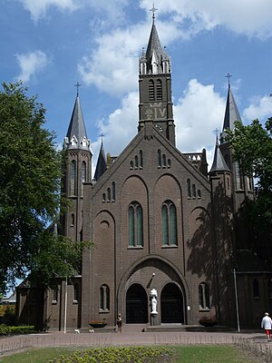
Etten-Leur
Municipality in North Brabant, Netherlands
Distance: Approx. 1004 meters
Latitude and longitude: 51.56666667,4.63333333
Etten-Leur (Dutch pronunciation: [ˌɛtə(n) ˈløːr] ) is a municipality in the Dutch province North Brabant. Its name is a combination of the two villages from which the municipality originally acrose: Etten and Leur.

Halderberge
Municipality in North Brabant, Netherlands
Distance: Approx. 6350 meters
Latitude and longitude: 51.58333333,4.53333333
Halderberge (Dutch pronunciation: [ˈɦɑldərˌbɛrɣə] ) is a municipality in the southern Netherlands.

Rucphen
Municipality in North Brabant, Netherlands
Distance: Approx. 4218 meters
Latitude and longitude: 51.53333333,4.58333333
Rucphen (pronounced [ˈrʏkfə(n)] ) is a municipality and a town in the southern Netherlands between Roosendaal and Etten-Leur, south of the railway, but without a train-station.

Sprundel
Village in North Brabant, Netherlands
Distance: Approx. 3457 meters
Latitude and longitude: 51.53638889,4.59611111
Sprundel is a village in the southern Netherlands, in the Rucphen municipality. In the past it was the main village of the region, with roads to Roosendaal to the west, Breda to the east, Rotterdam to the north and Antwerp to the south. The village was first mentioned in 1282 as "Hermano filio Nekers de Sprundele".
Sint Willebrord
Town in North Brabant, Netherlands
Distance: Approx. 2449 meters
Latitude and longitude: 51.55027778,4.59166667
Sint Willebrord is a town in the municipality of Rucphen in the Netherlands. It is also known by the name 't Heike which was the semi-official name up until 1950/1970 (mostly written as Theike, or less often Heike), which is the diminutive form of hei (heath) in local dialect. This town was formed on the former boundary between the "Baronie of Breda" and "Het Markizaat of Bergen op Zoom".
Kruisstraat, Halderberge
Distance: Approx. 4567 meters
Latitude and longitude: 51.58833333,4.56666667
Kruisstraat is a hamlet in the south of the Netherlands. It is located in the municipality of Halderberge, North Brabant, between the towns of Oudenbosch and Hoeven.
Lies, North Brabant
Hamlet in North Brabant, The Netherlands
Distance: Approx. 6372 meters
Latitude and longitude: 51.57,4.71111111
Lies is a hamlet in the Dutch province of North Brabant. It is located in the municipality of Breda, about 5 km southwest of the city centre.
Heikant, Rucphen
Distance: Approx. 3833 meters
Latitude and longitude: 51.52972222,4.6275
Heikant is a hamlet in the municipality of Rucphen, in the Dutch province of North Brabant. It is located about 2 km southeast of Sprundel.

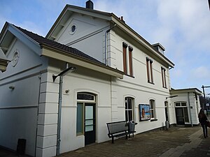
Etten-Leur railway station
Railway station in the Netherlands
Distance: Approx. 1754 meters
Latitude and longitude: 51.57527778,4.63694444
Etten-Leur is a railway station located in Etten-Leur, Netherlands. The station was opened on 11 December 1854 and is located on the Roosendaal–Breda railway. The station is operated by Nederlandse Spoorwegen.
Oudenbosch railway station
Railway station in Oudenbosch, Netherlands
Distance: Approx. 6531 meters
Latitude and longitude: 51.58805556,4.53361111
Oudenbosch is a railway station located in Oudenbosch, Netherlands. The station was opened on October 20, 1854, and is located on the Antwerp–Lage Zwaluwe railway. The train services are operated by Nederlandse Spoorwegen.

Bosschenhoofd
Village in North Brabant, Netherlands
Distance: Approx. 5422 meters
Latitude and longitude: 51.56055556,4.54138889
Bosschenhoofd is a village in the municipality of Halderberge in the province of North Brabant in the Netherlands. The village is also known as Seppe, a name used by the nearby Seppe Airport. Seppe was derived from Jacobus Sep who ran an inn.
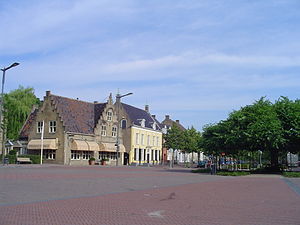
De Zwaan (restaurant)
Restaurant in Etten-Leur, Netherlands
Distance: Approx. 1276 meters
Latitude and longitude: 51.56968333,4.63540278
Restaurant De Zwaan is a restaurant located in Etten-Leur, in the Netherlands. It is a fine dining restaurant that was awarded one Michelin star in the period 1994–present. Gault Millau awarded the restaurant 16 out of 20 points.
Weather in this IP's area
overcast clouds
15 Celsius
14 Celsius
14 Celsius
15 Celsius
1017 hPa
93 %
1017 hPa
1016 hPa
10000 meters
4.12 m/s
8.76 m/s
209 degree
97 %
08:12:43
18:39:46