185.44.144.30 - IP Lookup: Free IP Address Lookup, Postal Code Lookup, IP Location Lookup, IP ASN, Public IP
Country:
 Greece
Region:
City:
Location:
Time Zone:
Postal Code:
ISP:
ASN:
language:
User-Agent:
Proxy IP:
Blacklist:
IP information under different IP Channel
ip-api
Country
Region
City
ASN
Time Zone
ISP
Blacklist
Proxy
Latitude
Longitude
Postal
Route
db-ip
Country
Region
City
ASN
Time Zone
ISP
Blacklist
Proxy
Latitude
Longitude
Postal
Route
IPinfo
Country
Region
City
ASN
Time Zone
ISP
Blacklist
Proxy
Latitude
Longitude
Postal
Route
IP2Location
185.44.144.30Country
grRegion
kentriki makedonia
City
peraia
Time Zone
Europe/Athens
ISP
Language
User-Agent
Latitude
Longitude
Postal
ipdata
Country
Region
City
ASN
Time Zone
ISP
Blacklist
Proxy
Latitude
Longitude
Postal
Route
Popular places and events near this IP address

Thessaloniki Airport
International airport serving Thessaloniki, Greece
Distance: Approx. 4447 meters
Latitude and longitude: 40.51972222,22.97091667
Thessaloniki Airport (IATA: SKG, ICAO: LGTS), officially Thessaloniki Airport "Makedonia" (Greek: Κρατικός Αερολιμένας Θεσσαλονίκης «Μακεδονία», romanized: Kratikós Aeroliménas Thessaloníkis "Makedonía") and formerly Mikra Airport, is an international airport serving Thessaloniki, the second-largest city in Greece. It is located 13 km (8 mi) southeast of the city, in Thermi. The airport is the third-largest airport in the country after Athens International Airport and Heraklion International Airport.

Peraia, Thessaloniki
Community in Greece
Distance: Approx. 33 meters
Latitude and longitude: 40.5,22.925
Peraia (Greek: Περαία) is a suburb of Thessaloniki, Greece. It is part of the municipality Thermaikos. Peraia is located on the south coast of the Thermaic Gulf, 15 km south of Thessaloniki city centre and 4 km west of Thessaloniki International Airport.

Neoi Epivates
Town in Greece
Distance: Approx. 1357 meters
Latitude and longitude: 40.501,22.909
Neoi Epivates (Greek: Νέοι Επιβάτες) is a small suburban town outside Thessaloniki, next to Peraia. It is part of the municipality of Thermaikos in the Thessaloniki regional unit. The origin of the settlement was the arrival of 631 refugees from the town Epivates in Eastern Thrace as a result of the Greco-Turkish War (1919–22).

Thermaikos
Municipality in Greece
Distance: Approx. 706 meters
Latitude and longitude: 40.5,22.91666667
Thermaikos (Greek: Θερμαϊκός) is a suburban municipality of the regional unit of Thessaloniki, Greece. It consists of the municipal units Thermaikos, Epanomi and Michaniona. The municipal unit Thermaikos is subdivided into the communities Peraia, Neoi Epivates and Agia Triada.

Mikra, Thessaloniki
Municipal unit in Greece
Distance: Approx. 6198 meters
Latitude and longitude: 40.46666667,22.98333333
Mikra (Greek: Μίκρα, Míkra) is a former municipality in the Thessaloniki regional unit, Greece. Since the 2011 local government reform it is part of the municipality Thermi, of which it is a municipal unit. Population 17,150 (2021).
Trilofo, Thessaloniki
Community in Greece
Distance: Approx. 5443 meters
Latitude and longitude: 40.46666667,22.97166667
Trilofo (Greek: Τρίλοφο) is a village and a community of the Thermi municipality. Before the 2011 local government reform it was part of the municipality of Mikra, of which it was a municipal district. The 2021 census recorded 6,727 inhabitants in the community of Trilofo.
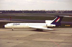
Malév Flight 262
2000 aviation accident in Greece
Distance: Approx. 4441 meters
Latitude and longitude: 40.51972222,22.97083333
Malév Hungarian Airlines Flight 262 was a flight from Budapest Ferihegy International Airport to Thessaloniki International Airport. On 4 July 2000, a Tupolev Tu-154, belonging to Malév Hungarian Airlines, performed a gear-up touchdown during the landing at Thessaloniki, skidded on the runway, but was able to take off and land normally after a go-around. No injuries were reported.

Plagiari, Thessaloniki
Community in Greece
Distance: Approx. 4120 meters
Latitude and longitude: 40.47333333,22.95833333
Plagiari (Greek: Πλαγιάρι) is a village and a community of the Thermi municipality. Before the 2011 local government reform it was part of the municipality of Mikra, of which it was a municipal district. The 2021 census recorded 5,091 inhabitants in the village.
Neo Rysio
Community in Greece
Distance: Approx. 5394 meters
Latitude and longitude: 40.495,22.98833333
Neo Rysio (Greek: Νέο Ρύσιο) is a village and a community of the Thermi municipality. Before the 2011 local government reform it was part of the municipality of Thermi, of which it was a municipal district. The 2021 census recorded 2,845 inhabitants in the village.
Agia Triada, Thessaloniki
Community in Greece
Distance: Approx. 4091 meters
Latitude and longitude: 40.5,22.87666667
Agia Triada (Greek: Αγία Τριάδα) is a village and a community of the Thermaikos municipality. Before the 2011 local government reform it was part of the municipality of Thermaikos, of which it was a municipal district. The 2021 census recorded 1,990 inhabitants in the village.
Nea Kerasia
Community in Greece
Distance: Approx. 5563 meters
Latitude and longitude: 40.475,22.86833333
Nea Kerasia (Greek: Νέα Κερασιά) is a village and a community of the Thermaikos municipality. Before the 2011 local government reform it was part of the municipality of Michaniona, of which it was a municipal district. The 2021 census recorded 1,864 inhabitants in the village.
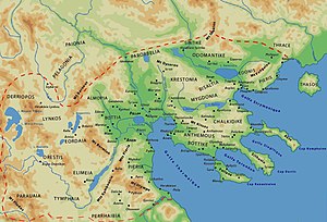
Dicaea (Macedonia)
Distance: Approx. 4811 meters
Latitude and longitude: 40.460491,22.947121
Dicaea or Dikaia (Ancient Greek: Δικαία or Δίκαια) was an ancient Greek city in northwest Chalcidice. It was an Eretrian colony as seen from the Athenian tribute lists. The site of Dicaea is located at Nea Kallikrateia, near modern Epanome.
Weather in this IP's area
scattered clouds
8 Celsius
6 Celsius
7 Celsius
10 Celsius
1030 hPa
62 %
1030 hPa
1020 hPa
10000 meters
2.68 m/s
6.26 m/s
267 degree
40 %