Country:
 Cyprus
Region:
City:
Latitude and Longitude:
Time Zone:
Postal Code:
IP information under different IP Channel
ip-api
Country
Region
City
ASN
Time Zone
ISP
Blacklist
Proxy
Latitude
Longitude
Postal
Route
IPinfo
Country
Region
City
ASN
Time Zone
ISP
Blacklist
Proxy
Latitude
Longitude
Postal
Route
MaxMind
Country
Region
City
ASN
Time Zone
ISP
Blacklist
Proxy
Latitude
Longitude
Postal
Route
Luminati
Country
CYASN
Time Zone
Asia/Nicosia
ISP
Primetel PLC
Latitude
Longitude
Postal
db-ip
Country
Region
City
ASN
Time Zone
ISP
Blacklist
Proxy
Latitude
Longitude
Postal
Route
ipdata
Country
Region
City
ASN
Time Zone
ISP
Blacklist
Proxy
Latitude
Longitude
Postal
Route
Popular places and events near this IP address

Strovolos
Municipality in Nicosia District, Cyprus
Distance: Approx. 4017 meters
Latitude and longitude: 35.15,33.33333333
Strovolos (Greek: Στρόβολος; Turkish: Strovolos; Armenian: Ստրովոլոս) is a municipality in the Nicosia district. With a population of nearly 71,123, it is the second most populated municipality in Cyprus, after Limassol, and the most populated municipality of Nicosia District. It was established in 1986.

Makario Stadium
Sports venue in Cyprus
Distance: Approx. 2280 meters
Latitude and longitude: 35.14611111,33.31444444
Makario Stadium (Greek: Μακάρειο Στάδιο), is an all-seater multi-purpose stadium in Nicosia, Cyprus. It was the largest and main sports venue of the capital up to the construction of the GSP stadium in 1999. At present it is mostly used for football matches and is the home ground of Olympiakos Nicosia,Digenis Morphou, and Ethnikos Assia.
Eleftheria Indoor Hall
Distance: Approx. 2064 meters
Latitude and longitude: 35.147257,33.312066
Eleftheria Athletic Center (Greek: Αθλητικό Κέντρο "Ελευθερία"), officially named Tassos Papadopoulos Eleftheria Indoor Hall (Greek: κλειστό στάδιο "Τάσσος Παπαδόπουλος - Ελευθερία") is an indoor arena that is located besides Makario Stadium and Lefkotheo Indoor Hall in Engomi, Nicosia, Cyprus. The hall is mainly used for basketball events, although it can also be used for badminton, gymnastics, karate, taekwondo, handball, squash, volleyball, judo, futsal and table tennis. It is sometimes also used for national celebrations, for the declaration of the new President of Cyprus, and for musical concerts.

Nicosia International Airport
Closed airport in Cyprus
Distance: Approx. 1171 meters
Latitude and longitude: 35.15,33.27722222
Nicosia International Airport (Greek: Διεθνές Αεροδρόμιο Λευκωσίας, Turkish: Lefkoşa Uluslararası Havaalanı) is a largely disused airport located 8.2 km (5.1 mi) west of the Cypriot capital city of Nicosia in the Lakatamia suburb. It was originally the main airport for the island, but commercial activity ceased following the Turkish invasion of Cyprus in 1974. The airport site is now mainly used as the headquarters of the United Nations Peacekeeping Force in Cyprus.

Lakatamia
Municipality in Nicosia District, Cyprus
Distance: Approx. 4155 meters
Latitude and longitude: 35.11666667,33.31666667
Lakatamia (Greek: Λακατάμια [lakaˈtamɳa]; Turkish: Lakadamya) is a southwestern suburb of Nicosia, Cyprus. In terms of population, Lakatamia municipality is the third largest municipality in Nicosia district and the fifth largest municipality in Cyprus (after Limassol, Strovolos, Nicosia and Larnaca). In 2011 Lakatamia had a population of 38,345.
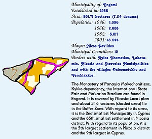
Engomi
Municipality in Nicosia District, Cyprus
Distance: Approx. 3064 meters
Latitude and longitude: 35.16305556,33.31638889
Engomi (Greek: Έγκωμη Turkish: Engomi or Enkomi) is a suburb and municipality of the Cypriot capital Nicosia. In 2011, it had a population of 18,010. Of these, 14,254 were citizens of Cyprus.
RAF Nicosia
Airport in Lefkosia, Cyprus
Distance: Approx. 934 meters
Latitude and longitude: 35.15052778,33.28033333
Royal Air Force Nicosia or more simply RAF Nicosia is a former Royal Air Force station on the island of Cyprus, built in the 1930s. The station served as Headquarters Royal Air Force Cyprus from 8 June to 29 July 1941. The original principal airport for Cyprus, Nicosia International Airport, was built within the site of the RAF station.
Lefkotheo
Distance: Approx. 2358 meters
Latitude and longitude: 35.1475,33.31527778
The Lefkotheo Indoor Hall is an indoor arena in Nicosia, Cyprus. It is located next to the Makario Stadium, with which it shares a common car parking lot. It has a crowd capacity of 3,000 seated spectators.

1967 Nicosia Globe Air Bristol Britannia crash
1967 aviation accident
Distance: Approx. 4264 meters
Latitude and longitude: 35.10833333,33.28722222
On 20 April, 1967, a Bristol Britannia aircraft of the Swiss airline Globe Air flew into the ground 3.5 kilometres (2.2 mi) south of Nicosia Airport, in Cyprus killing all 126 passengers and crew onboard.
Costas Papaellinas Arena
Indoor arena in Strovolos, Nicosia, Cyprus
Distance: Approx. 4629 meters
Latitude and longitude: 35.1517966,33.3398598
Costas Papaellinas Arena is an indoor arena in Strovolos, Nicosia, Cyprus. It is the home venue of the Keravnos BC. Currently the arena has a capacity around 2,000 seats.

Blue Beret Camp
Distance: Approx. 956 meters
Latitude and longitude: 35.15512,33.2907
Blue Beret Camp is a base camp and headquarters located at the former Nicosia International Airport on the west side of the city of Nicosia, on the Mediterranean island of Cyprus, which forms the headquarters of the United Nations Peacekeeping Force in Cyprus (UNFICYP).

Makedonitissa Tomb
Military cemetery and war memorial in Cyprus
Distance: Approx. 1895 meters
Latitude and longitude: 35.15416667,33.30805556
The Makedonitissa Tomb (Greek: Τύμβος της Μακεδονίτισσας) is a military cemetery and war memorial west of Nicosia, at Engomi in the area of Makedonitissa. This is the location where one Greek Nord Noratlas was shot down by friendly fire on 22 July 1974, during Operation "Niki". "Niki" was a military operation of the Greek Armed Forces to airlift a battalion of Greek commandos to Cyprus in order to reinforce the Cypriot National Guard against Turkish invasion forces.
Weather in this IP's area
scattered clouds
20 Celsius
21 Celsius
20 Celsius
22 Celsius
1010 hPa
78 %
1010 hPa
986 hPa
10000 meters
4.63 m/s
230 degree
40 %
06:33:29
18:47:02