185.41.6.58 - IP Lookup: Free IP Address Lookup, Postal Code Lookup, IP Location Lookup, IP ASN, Public IP
Country:
Region:
City:
Location:
Time Zone:
Postal Code:
IP information under different IP Channel
ip-api
Country
Region
City
ASN
Time Zone
ISP
Blacklist
Proxy
Latitude
Longitude
Postal
Route
Luminati
Country
Region
idf
City
fontenaysousbois
ASN
Time Zone
Europe/Paris
ISP
Celeste SAS
Latitude
Longitude
Postal
IPinfo
Country
Region
City
ASN
Time Zone
ISP
Blacklist
Proxy
Latitude
Longitude
Postal
Route
IP2Location
185.41.6.58Country
Region
provence-alpes-cote-d'azur
City
sophia antipolis
Time Zone
Europe/Paris
ISP
Language
User-Agent
Latitude
Longitude
Postal
db-ip
Country
Region
City
ASN
Time Zone
ISP
Blacklist
Proxy
Latitude
Longitude
Postal
Route
ipdata
Country
Region
City
ASN
Time Zone
ISP
Blacklist
Proxy
Latitude
Longitude
Postal
Route
Popular places and events near this IP address

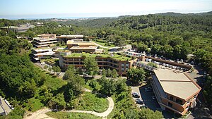
Sophia Antipolis
Technology park in Provence-Alpes-Côte d'Azur, France
Distance: Approx. 2 meters
Latitude and longitude: 43.62222222,7.05
Sophia Antipolis is a 2,400 hectare technology park in southeast France, and as of 2021 home to 2,500 companies, valued today at more than 5.6 billion euros and employing more than 38,000 people counting more than 80 nationalities. The park is known to be Europe's first science and technology hub. The technology park is also a platform, cluster and creation-hub for start-ups.

Valbonne
Commune in Provence-Alpes-Côte d'Azur, France
Distance: Approx. 3963 meters
Latitude and longitude: 43.6424,7.0095
Valbonne (French pronunciation: [valbɔn]; Occitan: Vauboa) is a commune near Nice in the Alpes-Maritimes department in the Provence-Alpes-Côte d'Azur region in southeastern France. Valbonne means "the good valley" in Provençal and translates to "Vaubona" in Occitan. The commune is part of the Communauté d'agglomération de Sophia Antipolis.
Vallauris
Commune in Provence-Alpes-Côte d'Azur, France
Distance: Approx. 4652 meters
Latitude and longitude: 43.5805,7.0538
Vallauris (French pronunciation: [valoʁis]; Occitan: Valàuria; Niçard subdialect: Valàuri) is a seaside commune in the Alpes-Maritimes department in the Provence-Alpes-Côte d'Azur region in Southeastern France. It is located in the metropolitan area (and is today effectively an extension of the city) of Antibes, bordering it on its west side. The seaside town Golfe-Juan is a part of the commune of Vallauris.
Biot, Alpes-Maritimes
Commune in Provence-Alpes-Côte d'Azur, France
Distance: Approx. 3800 meters
Latitude and longitude: 43.6294,7.0961
Biot (French pronunciation: [bjɔt]; Occitan: Biòt) is a small fortified medieval hilltop village in the Provence-Alpes-Côte d’Azur near Antibes, between Nice and Cannes. Many people come to Biot for its renowned cubist art museum of Fernand Leger as well as the winding cobbled lanes on the elevated fort. This village, that is now known for its ceramics and glassblowing, dates to prehistoric times.

Eurecom
Distance: Approx. 1864 meters
Latitude and longitude: 43.614376,7.07045
EURECOM is a French Graduate school (Grande École) and a research center in digital sciences. It is part of the Institut Mines-Télécom and it is a founding member of the SophiaTech Campus in Sophia Antipolis, the largest Science and Technology Information campus in the Alpes-Maritimes. It was created in 1991 as a Groupement d'intérêt économique with French and foreign academic and industrial members.

Valmasque
River in France
Distance: Approx. 4371 meters
Latitude and longitude: 43.61777778,7.10388889
The Valmasque is a small river that flows through the Alpes-Maritimes department of southeastern France. It is 8.4 km (5.2 mi) long. It flows into the Brague in Biot.
Mougins School
International school in Mougins, France
Distance: Approx. 2937 meters
Latitude and longitude: 43.6125,7.01611111
Mougins British International School, previously known as Mougins School is an international school situated in Mougins, France. It was established in 1964 and moved to its present site on the high technology park of Sophia Antipolis in 1987. The school was purchased by international education company Globeducate in 2021.

Polytech Nice Sophia
Distance: Approx. 1938 meters
Latitude and longitude: 43.615,7.0719
Ecole polytechnique de l'Université Côte d'Azur (Polytech Nice Sophia) a French engineering College based in the middle of the Sophia Antipolis technology park. The school has 989 engineering students, 50 doctoral students, 75 faculty members, 22 administrative and technical staff and 7 research laboratories associated. More than 200 engineers graduate each year.
Communauté d'agglomération de Sophia Antipolis
Communauté d'agglomération in Provence-Alpes-Côte d'Azur, France
Distance: Approx. 225 meters
Latitude and longitude: 43.62235,7.04721
The Communauté d'agglomération de Sophia Antipolis (CASA) is the communauté d'agglomération, an intercommunal structure, centred on the city of Antibes. It is located in the Alpes-Maritimes department, in the Provence-Alpes-Côte d'Azur region, southeastern France. It was created in 2002, and takes its name from the technology park Sophia Antipolis.

Canton of Valbonne
Canton in Provence-Alpes-Côte d'Azur, France
Distance: Approx. 3783 meters
Latitude and longitude: 43.64,7.01
The canton of Valbonne is an administrative division of the Alpes-Maritimes department, southeastern France. It was created at the French canton reorganisation which came into effect in March 2015. Its seat is in Valbonne.
Azur Arena Antibes
French sports arena
Distance: Approx. 2818 meters
Latitude and longitude: 43.60583333,7.07666667
The Azur Arena Antibes is a multi-purpose indoor arena that is located in Antibes, France. The arena can be to host basketball, gymnastics, handball, judo, tennis, and trampolining competitions, concerts, and cultural events. It is primarily used to host basketball games.

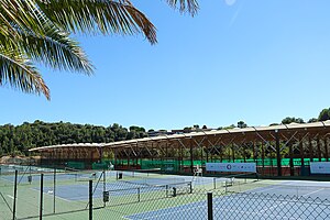
Mouratoglou Tennis Academy
Tennis academy in Biot, France
Distance: Approx. 999 meters
Latitude and longitude: 43.6206,7.0622
The Mouratoglou Tennis Academy is a tennis academy and training center in Biot, Alpes-Maritimes, France. Originally named the Bob Brett Academy, it was founded in 1996 by Patrick Mouratoglou and Bob Brett.
Weather in this IP's area
clear sky
5 Celsius
1 Celsius
5 Celsius
8 Celsius
1024 hPa
53 %
1024 hPa
1007 hPa
10000 meters
6.17 m/s
330 degree

