185.40.61.208 - IP Lookup: Free IP Address Lookup, Postal Code Lookup, IP Location Lookup, IP ASN, Public IP
Country:
Region:
City:
Location:
Time Zone:
Postal Code:
IP information under different IP Channel
ip-api
Country
Region
City
ASN
Time Zone
ISP
Blacklist
Proxy
Latitude
Longitude
Postal
Route
Luminati
Country
Region
lu
City
luxembourg
ASN
Time Zone
Europe/Luxembourg
ISP
Proximus Luxembourg S.A.
Latitude
Longitude
Postal
IPinfo
Country
Region
City
ASN
Time Zone
ISP
Blacklist
Proxy
Latitude
Longitude
Postal
Route
IP2Location
185.40.61.208Country
Region
esch-sur-alzette
City
niedercorn
Time Zone
ISP
Language
User-Agent
Latitude
Longitude
Postal
db-ip
Country
Region
City
ASN
Time Zone
ISP
Blacklist
Proxy
Latitude
Longitude
Postal
Route
ipdata
Country
Region
City
ASN
Time Zone
ISP
Blacklist
Proxy
Latitude
Longitude
Postal
Route
Popular places and events near this IP address

Differdange
Commune in Esch-sur-Alzette, Luxembourg
Distance: Approx. 1551 meters
Latitude and longitude: 49.5222,5.8917
Differdange (French pronunciation: [difɛʁdɑ̃ʒ]; Luxembourgish: Déifferdeng [ˈdɜɪ̯fɐdeŋ] or locally Déifferdang [ˈdɜɪ̯fɐdɑŋ]; German: Differdingen [ˈdɪfɐdɪŋən]) is a commune with town status in south-western Luxembourg, 27 kilometres (17 mi) west from the country's capital. It lies near the borders with Belgium and France and it is located in the canton of Esch-sur-Alzette. With a population of around 29,500, Differdange is the country's third largest city.

Niederkorn
Distance: Approx. 586 meters
Latitude and longitude: 49.53333333,5.9
Niederkorn (Luxembourgish: Nidderkuer) is a town in the commune of Differdange, in south-western Luxembourg, on the Chiers river (German: Korn), from which it takes its name. As of 2024, the town has a population of 7,663. Niederkorn is home to FC Progrès Niederkorn, a football team in Luxembourg's National Division.
Oberkorn
Town in the commune of Differdange in Luxembourg
Distance: Approx. 2220 meters
Latitude and longitude: 49.51666667,5.9
Oberkorn (Luxembourgish: Uewerkuer, pronounced [ˈuːɐ̯vɐkuːɐ̯] de: Oberkorn ) is a town in the commune of Differdange in south-western Luxembourg. As of 2024, the town had a population of 4,737.

Stade du Thillenberg
Football stadium in Luxembourg
Distance: Approx. 2008 meters
Latitude and longitude: 49.522158,5.875475
Stade du Thillenberg is a football stadium in Differdange, in south-western Luxembourg. It is currently the home stadium of FC Differdange 03. Until 2003, it was the home of Red Boys Differdange.

Stade Jos Haupert
Football stadium in Luxembourg
Distance: Approx. 1339 meters
Latitude and longitude: 49.5461,5.9034
Stade Jos Haupert is a football stadium in Niederkorn, in southwestern Luxembourg. It is currently the home stadium of FC Progrès Niederkorn. The stadium has a capacity of 2,800.
Miami University Dolibois European Center
Overseas campus of Miami University based in Luxembourg
Distance: Approx. 1662 meters
Latitude and longitude: 49.5214,5.8891
The Miami University John E. Dolibois European Center (MUDEC) is an overseas campus of Miami University based in Differdange, Luxembourg. Established in 1968, the program is based in Differdange Castle in southwestern Luxembourg and enrolls around 125 students each semester from Miami and other American universities. The center is named after John E. Dolibois, a native Luxembourger who was a Miami University graduate and administrator as well as the United States Ambassador to Luxembourg from 1981 to 1985.

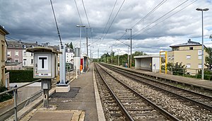
Niederkorn railway station
Railway station in Differdange, Luxembourg
Distance: Approx. 122 meters
Latitude and longitude: 49.535,5.89305556
Niederkorn railway station (Luxembourgish: Gare Nidderkuer, French: Gare de Niederkorn, German: Bahnhof Niederkorn) is a railway station serving Niederkorn, in the commune of Differdange, in south-western Luxembourg. It is operated by Chemins de Fer Luxembourgeois, the state-owned railway company. The station is situated on Line 60, which connects Luxembourg City to the Red Lands of the south of the country.

Pétange railway station
Railway station in Luxembourg
Distance: Approx. 2269 meters
Latitude and longitude: 49.55388889,5.87777778
Pétange railway station (Luxembourgish: Gare Péiteng, French: Gare de Pétange, German: Bahnhof Petingen) is a railway station serving Pétange, in south-western Luxembourg. It is operated by Chemins de Fer Luxembourgeois, the state-owned railway company. The station is the main terminus of Line 60, which connects Luxembourg City to the Red Lands of the south of the country.

Differdange railway station
Railway station in Differdange, Luxembourg
Distance: Approx. 1802 meters
Latitude and longitude: 49.52,5.89055556
Differdange railway station (Luxembourgish: Gare Déifferdeng, French: Gare de Differdange, German: Bahnhof Differdingen) is a railway station serving Differdange, in south-western Luxembourg. It is operated by CFL, the state-owned railway company. The station is situated on Line 60, which connects Luxembourg City to the Red Lands (Minett) region.

Titelberg
Celtic oppidum in Luxembourg
Distance: Approx. 2216 meters
Latitude and longitude: 49.5375,5.8625
Titelberg (Luxembourgish: Tëtelbierg) is the site of a large Celtic settlement or oppidum in the extreme south west of Luxembourg. In the 1st century BCE, this thriving community was probably the capital of the Treveri people. The site thus provides telling evidence of urban civilization in the century before the Roman conquest.
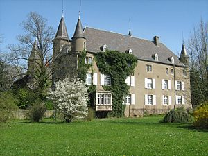
Differdange Castle
Distance: Approx. 1673 meters
Latitude and longitude: 49.52138889,5.88833333
Differdange Castle (Luxembourgish: Schlass Déifferdeng; French: Château de Differdange; German: Schloss Differdingen), located on a hill in the centre of Differdange in southern Luxembourg, was built in 1577 although an earlier fortified castle of Differdange dates from around 1310. Today's residential château is used by Miami University.

Aalt Stadhaus
Concert hall in Differdange, Luxembourg
Distance: Approx. 1732 meters
Latitude and longitude: 49.520936,5.887723
The Aalt Stadhaus is a concert hall located in Differdange, Luxembourg. Opened on 31 January 2014, it has a maximum capacity of 201 people. It is also the home of the Differdange Music School.
Weather in this IP's area
clear sky
-2 Celsius
-4 Celsius
-2 Celsius
-1 Celsius
1032 hPa
93 %
1032 hPa
988 hPa
10000 meters
1.79 m/s
2.68 m/s
305 degree
3 %

