185.39.140.36 - IP Lookup: Free IP Address Lookup, Postal Code Lookup, IP Location Lookup, IP ASN, Public IP
Country:
 France
Region:
City:
Location:
Time Zone:
Postal Code:
ISP:
ASN:
language:
User-Agent:
Proxy IP:
Blacklist:
IP information under different IP Channel
ip-api
Country
Region
City
ASN
Time Zone
ISP
Blacklist
Proxy
Latitude
Longitude
Postal
Route
db-ip
Country
Region
City
ASN
Time Zone
ISP
Blacklist
Proxy
Latitude
Longitude
Postal
Route
IPinfo
Country
Region
City
ASN
Time Zone
ISP
Blacklist
Proxy
Latitude
Longitude
Postal
Route
IP2Location
185.39.140.36Country
frRegion
grand-est
City
liepvre
Time Zone
Europe/Paris
ISP
Language
User-Agent
Latitude
Longitude
Postal
ipdata
Country
Region
City
ASN
Time Zone
ISP
Blacklist
Proxy
Latitude
Longitude
Postal
Route
Popular places and events near this IP address

Château du Haut-Koenigsbourg
Castle in Alsace, France
Distance: Approx. 5026 meters
Latitude and longitude: 48.24944444,7.34416667
The Château du Haut-Koenigsbourg (French: [ʃɑto dy o kœniksbuʁ]; German: Hohkönigsburg), sometimes also Haut-Kœnigsbourg, is a medieval castle located in the commune of Orschwiller in the Bas-Rhin département of Alsace, France. Located in the Vosges mountains just west of Sélestat, situated in a strategic area on a rocky spur overlooking the Upper Rhine Plain, it was used by successive powers from the Middle Ages until the Thirty Years' War when it was abandoned. From 1900 to 1908 it was rebuilt at the behest of the German kaiser Wilhelm II. Today it is a major tourist site, attracting more than 500,000 visitors a year.
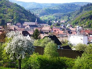
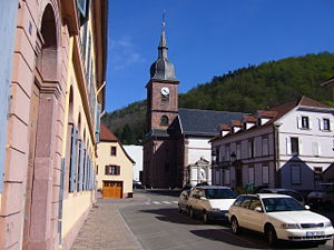
Lièpvre
Commune in Grand Est, France
Distance: Approx. 311 meters
Latitude and longitude: 48.2731,7.283
Lièpvre (French pronunciation: [ljɛvʁ]; German: Leberau) is a commune in the Haut-Rhin department in Grand Est in north-eastern France. A monastery was built here in the eighth century by Saint Fulrad, who filled it with relics of Saint Cucuphas and Saint Alexander.
Sainte-Croix-aux-Mines
Commune in Grand Est, France
Distance: Approx. 4380 meters
Latitude and longitude: 48.2628,7.2261
Sainte-Croix-aux-Mines (French pronunciation: [sɛ̃t kʁwa o min] ; German: Sankt Kreuz im Lebertal; Alsatian: Sànkriz) is a commune in the Haut-Rhin department in Grand Est in north-eastern France. It is part of the arrondissement of Colmar-Ribeauvillé. Coal mines were operating in the village until 1849.

Rombach-le-Franc
Commune in Grand Est, France
Distance: Approx. 2309 meters
Latitude and longitude: 48.2844,7.2611
Rombach-le-Franc (French pronunciation: [ʁɔ̃ba lə fʁɑ̃]; German: Deutsch-Rumbach) is a commune in the Haut-Rhin department in Grand Est in north-eastern France.

La Vancelle
Commune in Grand Est, France
Distance: Approx. 2388 meters
Latitude and longitude: 48.2869,7.3047
La Vancelle (French pronunciation: [la vɑ̃sɛl]; German: Wanzel) is a commune in the Bas-Rhin department in Alsace in north-eastern France.

Dieffenbach-au-Val
Commune in Grand Est, France
Distance: Approx. 5903 meters
Latitude and longitude: 48.315,7.3272
Dieffenbach-au-Val (German: Diefenbach) is a commune in the Bas-Rhin department in Alsace in north-eastern France.

Neubois
Commune in Grand Est, France
Distance: Approx. 5785 meters
Latitude and longitude: 48.3069,7.3397
Neubois (French pronunciation: [nøbwa]; German: Gereuth) is a commune in the Bas-Rhin department in Alsace in north-eastern France.

Breitenau, Bas-Rhin
Commune in Grand Est, France
Distance: Approx. 6389 meters
Latitude and longitude: 48.3275,7.2928
Breitenau is a commune in the Bas-Rhin department in Alsace in north-eastern France.

Taennchel
Distance: Approx. 4389 meters
Latitude and longitude: 48.23472222,7.25888889
The Taennchel is one of the summits of the Vosges Mountains, rising to 988 metres (3,241 ft). The Taennchel rises at the East of France, in the département of Haut-Rhin (region Alsace), halfway between Strasbourg to the North and Mulhouse to the South, around 60 km (40 mi) from both cities. The general area around the crest, which is 6 km long, is enigmatic.

Thannenkirch
Commune in Grand Est, France
Distance: Approx. 4396 meters
Latitude and longitude: 48.2333,7.3044
Thannenkirch (French pronunciation: [tanənkiʁʃ] ) is a commune and tourist destination in the northeastern French department of Haut-Rhin.

Château du Frankenbourg
Ruined 12th century castle in Neubois in the Bas-Rhin département in Alsace, France
Distance: Approx. 4105 meters
Latitude and longitude: 48.29527778,7.325
The Château de Frankenbourg is a ruined 12th century castle in the commune of Neubois in the Bas-Rhin département in Alsace, France. The castle is state-owned. It has been listed since 1898 as a monument historique by the French Ministry of Culture.

Château Burrus
French abandoned chateau in Alsace
Distance: Approx. 4531 meters
Latitude and longitude: 48.2629,7.224
Château Burrus is a château in Sainte-Croix-aux-Mines, in the department of Haut-Rhin, Alsace, France. It was built in 1900 and has been listed as a historical monument since 1993.
Weather in this IP's area
clear sky
2 Celsius
2 Celsius
2 Celsius
2 Celsius
1022 hPa
75 %
1022 hPa
962 hPa
10000 meters
1.03 m/s
330 degree