Country:
 Germany
Region:
City:
Latitude and Longitude:
Time Zone:
Postal Code:
IP information under different IP Channel
ip-api
Country
Region
City
ASN
Time Zone
ISP
Blacklist
Proxy
Latitude
Longitude
Postal
Route
IPinfo
Country
Region
City
ASN
Time Zone
ISP
Blacklist
Proxy
Latitude
Longitude
Postal
Route
MaxMind
Country
Region
City
ASN
Time Zone
ISP
Blacklist
Proxy
Latitude
Longitude
Postal
Route
Luminati
Country
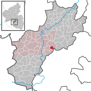
DERegion
rp
City
kottweilerschwanden
ASN
Time Zone
Europe/Berlin
ISP
VSE NET GmbH
Latitude
Longitude
Postal
db-ip
Country
Region
City
ASN
Time Zone
ISP
Blacklist
Proxy
Latitude
Longitude
Postal
Route
ipdata
Country
Region
City
ASN
Time Zone
ISP
Blacklist
Proxy
Latitude
Longitude
Postal
Route
Popular places and events near this IP address

Ramstein-Miesenbach
Town in Rhineland-Palatinate, Germany
Distance: Approx. 4660 meters
Latitude and longitude: 49.44611111,7.55472222
Ramstein-Miesenbach is a town in the district of Kaiserslautern in Rhineland-Palatinate in Germany, adjacent to the U.S. Ramstein Air Base.

Schwedelbach
Municipality in Rhineland-Palatinate, Germany
Distance: Approx. 4160 meters
Latitude and longitude: 49.49611111,7.59166667
Schwedelbach is a community in the district of Kaiserslautern, southern Rhineland-Palatinate, Germany. It is part of the Verbandsgemeinde Weilerbach.

Oberstaufenbach
Municipality in Rhineland-Palatinate, Germany
Distance: Approx. 3731 meters
Latitude and longitude: 49.51479167,7.50926111
Oberstaufenbach is an Ortsgemeinde – a municipality belonging to a Verbandsgemeinde, a kind of collective municipality – in the Kusel district in Rhineland-Palatinate, Germany. It belongs to the Verbandsgemeinde of Kusel-Altenglan, whose seat is in Kusel.

Kollweiler
Municipality in Rhineland-Palatinate, Germany
Distance: Approx. 4801 meters
Latitude and longitude: 49.51583333,7.58444444
Kollweiler is a municipality in the district of Kaiserslautern, in Rhineland-Palatinate, western Germany.

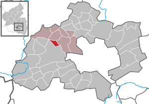
Kottweiler-Schwanden
Municipality in Rhineland-Palatinate, Germany
Distance: Approx. 1280 meters
Latitude and longitude: 49.47472222,7.53722222
Kottweiler-Schwanden is a municipality in the district of Kaiserslautern, in Rhineland-Palatinate, western Germany.
Mackenbach
Municipality in Rhineland-Palatinate, Germany
Distance: Approx. 3919 meters
Latitude and longitude: 49.47166667,7.58555556
Mackenbach is a municipality in the district of Kaiserslautern, in Rhineland-Palatinate, western Germany.

Reichenbach-Steegen
Municipality in Rhineland-Palatinate, Germany
Distance: Approx. 1845 meters
Latitude and longitude: 49.50277778,7.53638889
Reichenbach-Steegen is a municipality in the district of Kaiserslautern, in Rhineland-Palatinate, western Germany. It has a twin town in France, Magny-en-Vexin.
Steinwenden
Municipality in Rhineland-Palatinate, Germany
Distance: Approx. 3450 meters
Latitude and longitude: 49.45583333,7.52666667
Steinwenden is a municipality in the district of Kaiserslautern, in Rhineland-Palatinate, western Germany.
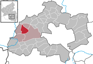
Ramstein-Miesenbach (Verbandsgemeinde)
Distance: Approx. 4253 meters
Latitude and longitude: 49.45,7.555
Ramstein-Miesenbach is a Verbandsgemeinde ("collective municipality") in the district of Kaiserslautern, Rhineland-Palatinate, Germany. The seat of the Verbandsgemeinde is in Ramstein-Miesenbach.
Niederstaufenbach
Municipality in Rhineland-Palatinate, Germany
Distance: Approx. 4886 meters
Latitude and longitude: 49.52849,7.51813
Niederstaufenbach is an Ortsgemeinde – a municipality belonging to a Verbandsgemeinde, a kind of collective municipality – in the Kusel district in Rhineland-Palatinate, Germany. It belongs to the Verbandsgemeinde of Kusel-Altenglan, whose seat is in Kusel.

Neunkirchen am Potzberg
Municipality in Rhineland-Palatinate, Germany
Distance: Approx. 4273 meters
Latitude and longitude: 49.50867,7.48829
Neunkirchen am Potzberg is an Ortsgemeinde – a municipality belonging to a Verbandsgemeinde, a kind of collective municipality – in the Kusel district in Rhineland-Palatinate, Germany. It belongs to the Verbandsgemeinde of Kusel-Altenglan, whose seat is in Kusel.
West Palatine Musicians Museum
Distance: Approx. 3840 meters
Latitude and longitude: 49.4716,7.5843
The West Palatine Musicians Museum (German: Westpfälzer Musikantenmuseum) in Mackenbach, Germany, documents the history of the Westphalian Wandering Musicians, the heyday of which was between 1850 and the First World War. In addition to musical instruments of the travelling musicians, there is an extensive collection of African musical instruments, historical photos of the villages and houses of musicians and souvenirs of travellers are on display. The linkages between the Musikantenland ("Musicians' Land") and the culture of German emigrants, especially in the US, are also explained.
Weather in this IP's area
clear sky
12 Celsius
11 Celsius
11 Celsius
14 Celsius
1020 hPa
92 %
1020 hPa
980 hPa
10000 meters
3.41 m/s
8.56 m/s
48 degree
07:13:45
19:32:44