185.35.177.173 - IP Lookup: Free IP Address Lookup, Postal Code Lookup, IP Location Lookup, IP ASN, Public IP
Country:
 Bulgaria
Region:
City:
Location:
Time Zone:
Postal Code:
ISP:
ASN:
language:
User-Agent:
Proxy IP:
Blacklist:
IP information under different IP Channel
ip-api
Country
Region
City
ASN
Time Zone
ISP
Blacklist
Proxy
Latitude
Longitude
Postal
Route
db-ip
Country
Region
City
ASN
Time Zone
ISP
Blacklist
Proxy
Latitude
Longitude
Postal
Route
IPinfo
Country
Region
City
ASN
Time Zone
ISP
Blacklist
Proxy
Latitude
Longitude
Postal
Route
IP2Location
185.35.177.173Country
bgRegion
stara zagora
City
kazanlak
Time Zone
Europe/Sofia
ISP
Language
User-Agent
Latitude
Longitude
Postal
ipdata
Country
Region
City
ASN
Time Zone
ISP
Blacklist
Proxy
Latitude
Longitude
Postal
Route
Popular places and events near this IP address

Kazanlak
Place in Stara Zagora, Bulgaria
Distance: Approx. 4 meters
Latitude and longitude: 42.61666667,25.4
Kazanlak (Bulgarian: Казанлък [kɐzɐnˈɫɤk], known as Seuthopolis (Greek: Σευθόπολις) in ancient times, is a town in Stara Zagora Province, Bulgaria. It is located in the middle of the plain of the same name, at the foot of the Balkan mountain range, at the eastern end of the Rose Valley. It is the administrative centre of the homonymous Kazanlak Municipality.
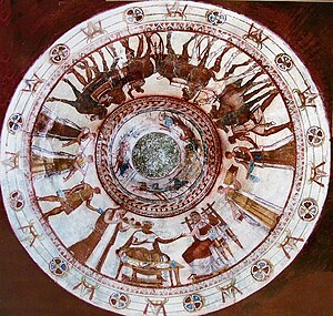
Thracian Tomb of Kazanlak
UNESCO World Heritage Site in Stara Zagora Province, Bulgaria
Distance: Approx. 1011 meters
Latitude and longitude: 42.62576,25.39919
The Thracian Tomb of Kazanlak (Bulgarian: Казанлъшка гробница, Kazanlǎška grobnica) is a vaulted-brickwork "beehive" (tholos) tomb that is located near the town of Kazanlak in central Bulgaria. The tomb is part of a large royal Thracian necropolis in the Valley of the Thracian Rulers near their ancient capital of Seuthopolis in a region where more than a thousand tombs of royalty and members of the Thracian aristocracy can be found. The monument dates back to the fourth century BC and has been on the UNESCO protected World Heritage Site list since 1979.

Seuthopolis
Ancient city
Distance: Approx. 7738 meters
Latitude and longitude: 42.61805556,25.30555556
Seuthopolis (Ancient Greek: Σευθόπολις) was an ancient hellenistic-type city founded by the Thracian king Seuthes III between 325–315 BC which was the capital of the Odrysian kingdom. Its ruins are now located at the bottom of the Koprinka Reservoir near Kazanlak, Stara Zagora Province, in central Bulgaria. Several kilometres north of the city is the Valley of the Thracian Rulers where many magnificent royal tombs are located.

Rose Valley, Bulgaria
Area in central Bulgaria
Distance: Approx. 4 meters
Latitude and longitude: 42.61666667,25.4
The Rose Valley (Bulgarian: Розова долина, romanized: Rozova dolina) is a region in Bulgaria located just south of the Balkan Mountains in older times and still called among Slavs mainly ones on south "Old Mountain" and the eastern part of the lower Sredna Gora chain to the south. Geologically, it consists of two river valleys, those of the Stryama to the west and the Tundzha to the east. The Rose Valley of Kazanlak stretches for 10-12 kilometers and is 95 kilometers long with an average height of 350 meters and an area of 1895 square kilometers.

Shipka (town)
Place in Stara Zagora, Bulgaria
Distance: Approx. 9373 meters
Latitude and longitude: 42.7,25.38333333
Shipka (Bulgarian: Шипка [ˈʃipkɐ], "Rosa canina") is a town in central Bulgaria, part of Kazanlak Municipality, Stara Zagora Province. It lies in the Central Balkan Mountains, at 42°42′N 25°23′E, 650 metres above sea level. As of 2005, Shipka had a population of 1,398 and the mayor was Stoyan Ivanov.
Kazanlak Airport
Airport in Bulgaria
Distance: Approx. 3792 meters
Latitude and longitude: 42.58813889,25.42522222
Kazanlak Airport (Bulgarian: Летище Казанлък, romanized: Letishte Kazanlak) is a grass airfield which serves the city of Kazanlak. The airport is near the Ovoshtnik village, about 9 km south from the city center of Kazanlak. It is also known as Kazanlak Airfield.

Koprinka Reservoir
Reservoir in Stara Zagora Province
Distance: Approx. 6827 meters
Latitude and longitude: 42.61666667,25.31666667
Koprinka (Bulgarian: Копринка) is a reservoir and dam in the Rose Valley, central Bulgaria. Its construction began after 1944 and was finished in 1956. It was built on the Tundzha river at 7 km to the west of the city of Kazanlak near the village of Koprinka.
Kran, Stara Zagora Province
Place in Stara Zagora, Bulgaria
Distance: Approx. 5763 meters
Latitude and longitude: 42.66694444,25.38305556
Kran (Bulgarian: Крън, pronounced [ˈkrɤn]; also transliterated as Krun or Krǎn) is a town in central Bulgaria. It is located just south of the Balkan Mountains and is administratively part of Kazanlak Municipality, Stara Zagora Province. Kran was an important castle of the Second Bulgarian Empire in the 13th–14th century.

Ostrusha mound
Ancient burial site in Shipka, Bulgaria
Distance: Approx. 9095 meters
Latitude and longitude: 42.69011111,25.35125
The Ostrusha mound is a Thracian burial tumulus near the Bulgarian town of Shipka. It was constructed in the middle of the 4th century BCE. The stone structures under the more than 18 meters high mound form one of the biggest representative tomb-cult complexes with 6 rooms on an area of 100 square meters. It was professionally excavated in 1993.
Weather in this IP's area
scattered clouds
3 Celsius
0 Celsius
3 Celsius
3 Celsius
1033 hPa
62 %
1033 hPa
948 hPa
10000 meters
2.48 m/s
4.17 m/s
354 degree
37 %