185.35.154.99 - IP Lookup: Free IP Address Lookup, Postal Code Lookup, IP Location Lookup, IP ASN, Public IP
Country:
Region:
City:
Location:
Time Zone:
Postal Code:
ISP:
ASN:
language:
User-Agent:
Proxy IP:
Blacklist:
IP information under different IP Channel
ip-api
Country
Region
City
ASN
Time Zone
ISP
Blacklist
Proxy
Latitude
Longitude
Postal
Route
db-ip
Country
Region
City
ASN
Time Zone
ISP
Blacklist
Proxy
Latitude
Longitude
Postal
Route
IPinfo
Country
Region
City
ASN
Time Zone
ISP
Blacklist
Proxy
Latitude
Longitude
Postal
Route
IP2Location
185.35.154.99Country
Region
tirol
City
seefeld in tirol
Time Zone
Europe/Vienna
ISP
Language
User-Agent
Latitude
Longitude
Postal
ipdata
Country
Region
City
ASN
Time Zone
ISP
Blacklist
Proxy
Latitude
Longitude
Postal
Route
Popular places and events near this IP address

Seefeld in Tirol
Municipality in Tyrol, Austria
Distance: Approx. 127 meters
Latitude and longitude: 47.32944444,11.18916667
Seefeld in Tirol is an old farming village, now a major tourist resort, in Innsbruck-Land District in the Austrian state of Tyrol with a local population of 3,312 (as of 1 January 2013). The village is located about 17 km (11 mi) northwest of Innsbruck on a plateau between the Wetterstein mountains and the Karwendel on a historic road from Mittenwald to Innsbruck that has been important since the Middle Ages. It was first mentioned in 1022 and since the 14th century has been a pilgrimage site, benefiting not only from the visit of numerous pilgrims but also from its stacking rights as a trading station between Augsburg and the Venice.

Reith bei Seefeld
Municipality in Tyrol, Austria
Distance: Approx. 3689 meters
Latitude and longitude: 47.29888889,11.20388889
Reith bei Seefeld is a municipality in the district of Innsbruck-Land in the Austrian state of Tyrol located 12.3 km northwest of Innsbruck and 3 km south of Seefeld in Tirol.

Toni-Seelos-Olympiaschanze
Ski jumping hill in Austria
Distance: Approx. 1305 meters
Latitude and longitude: 47.32083333,11.1775
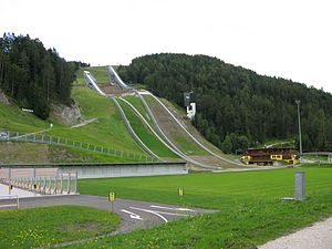
Toni-Seelos-Olympiaschanze is a ski jumping hill in Seefeld outside of Innsbruck, Austria. It is a part of the Seefeld Nordic Competence Centre consisting of two hills, a normal hill with a hill size of HS109 (K-99) and medium hill with at HS75 (K-68). Next to the jumps is a cross-country skiing stadium.

Schlossberg Castle (Seefeld in Tirol)
Distance: Approx. 1832 meters
Latitude and longitude: 47.343411,11.202374
Schlossberg Castle (German: Burg Schlossberg) is a ruined toll castle in the municipality of Seefeld in Tirol in the district of Innsbruck Land in the Austrian state of Tyrol.

Reither Spitze
Austrian mountain
Distance: Approx. 3727 meters
Latitude and longitude: 47.322972,11.236125
The Reither Spitze is a mountain in the Karwendel in the Austrian federal state of Tyrol that, thanks to its location at the southwestern end of the Erlspitze Group, is particularly well known for its great views of the surrounding area from its summit. Its name is derived the village of Reith bei Seefeld, which lies at its southwestern foot. The Schlossbach, a tributary of the River Inn, rises on the mountainside.

Wildsee (Seefeld)
Distance: Approx. 915 meters
Latitude and longitude: 47.32222,11.19083
The Wildsee, occasionally also called the Seefelder See ("Lake Seefeld"), is a lake near the Austrian resort of Seefeld in Tirol at the foot of the Gschwandtkopf (1,495 m). It has an area of 6.1 hectares and a maximum depth of 5.1 metres. The majority of the lake belongs to the municipality of Seefeld, its south and west shores are part of Reith bei Seefeld.
Seefelder Spitze
Distance: Approx. 3753 meters
Latitude and longitude: 47.33278,11.2375
The Seefelder Spitze is a mountain east of Seefeld in Tirol in the Karwendel Alps in the Austrian state of Tyrol. It is 2,221 metres high and there is a summit cross at the top.

Seefeld Plateau
Distance: Approx. 408 meters
Latitude and longitude: 47.32861111,11.19277778
The Seefeld Plateau (German: Seefelder Plateau) is a montane valley and basin landscape in the North Tyrolean Limestone Alps about 500 metres above the Inn valley in the Austrian state of Tyrol. The plateau covers the valley basin around the villages of Seefeld in Tirol and Scharnitz as well as the valley of Leutaschtal.
Gschwandtkopf
Distance: Approx. 1939 meters
Latitude and longitude: 47.31389,11.17889
The Gschwandtkopf is a mountain south of the ski resort of Seefeld in Tirol in the Austrian state of Tyrol. It is 1,495 metres high. There are two inns at the summit: the Ötzi Hut and the Sonnenalm.
Wildmoossee
Distance: Approx. 3266 meters
Latitude and longitude: 47.332962,11.144804
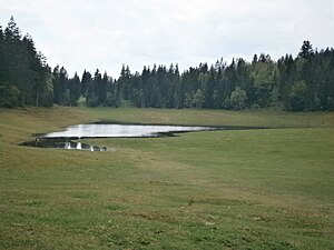
The Wildmoossee is an aperiodic mountain lake, 3 kilometres west of Seefeld in Tirol near the village of Wildmoos in the market borough of Telfs. The lake lies in the area of the water-soluble main dolomite of the Seefeld Plateau at a height of 1,316 metres. As a result the ground underneath contains chasms that reach up to the bottom of the lake.
Olympiaregion Seefeld
Distance: Approx. 134 meters
Latitude and longitude: 47.3292,11.1869
The Region Seefeld is a tourist region in Tyrol, Austria. It provides the entire infrastructure of a Nordic centre for winter sport and a wide range of facilities for the summer season.

Seefeld Saddle
Distance: Approx. 1517 meters
Latitude and longitude: 47.318083,11.197085
The Seefeld Saddle (German: Seefelder Sattel) is a saddle and mountain pass, 1,185 m (AA), in the Northern Limestone Alps in the Austrian federal state of Tyrol. Two major transport routes run over it: the Seefelder Straße (B 177) and the Mittenwald Railway. On the Seefeld Plateau north of the saddle lies the village and ski resort of Seefeld in Tirol (1,180 m (AA)).
Weather in this IP's area
few clouds
6 Celsius
5 Celsius
6 Celsius
6 Celsius
1018 hPa
43 %
1018 hPa
855 hPa
10000 meters
2.06 m/s
250 degree
20 %


