Country:
 Switzerland
Region:
City:
Latitude and Longitude:
Time Zone:
Postal Code:
IP information under different IP Channel
ip-api
Country
Region
City
ASN
Time Zone
ISP
Blacklist
Proxy
Latitude
Longitude
Postal
Route
IPinfo
Country
Region
City
ASN
Time Zone
ISP
Blacklist
Proxy
Latitude
Longitude
Postal
Route
MaxMind
Country
Region
City
ASN
Time Zone
ISP
Blacklist
Proxy
Latitude
Longitude
Postal
Route
Luminati
Country
CHASN
Time Zone
Europe/Zurich
ISP
Genossenschaft GGA Maur
Latitude
Longitude
Postal
db-ip
Country
Region
City
ASN
Time Zone
ISP
Blacklist
Proxy
Latitude
Longitude
Postal
Route
ipdata
Country
Region
City
ASN
Time Zone
ISP
Blacklist
Proxy
Latitude
Longitude
Postal
Route
Popular places and events near this IP address

Zumikon
Municipality in Zurich, Switzerland
Distance: Approx. 2737 meters
Latitude and longitude: 47.33333333,8.61666667
Zumikon is a municipality in the district of Meilen in the canton of Zürich in Switzerland. It is located in the Pfannenstiel region.
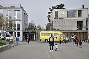
Inter-Community School Zurich
School in Zumikon, Switzerland
Distance: Approx. 2107 meters
Latitude and longitude: 47.338,8.6223
The Inter-Community School Zurich (ICS or ICSZ) is a private, independent, international, co-educational day school and offers a comprehensive educational programme in English for children from ages of 3 to 18. The school is international in character and welcomes students of all nationalities. Since 1971, the Inter-Community School has been located in Zumikon near Zurich, Switzerland.

Fällanden
Municipality in Zurich, Switzerland
Distance: Approx. 1192 meters
Latitude and longitude: 47.36666667,8.63333333
Fällanden is a municipality in the district of Uster in the canton of Zürich in Switzerland, and belongs to the Glatt Valley (German: Glattal).
Maur, Switzerland
Municipality in Zurich, Switzerland
Distance: Approx. 2851 meters
Latitude and longitude: 47.35,8.66666667
Maur is a municipality in the district of Uster in the canton of Zürich in Switzerland.
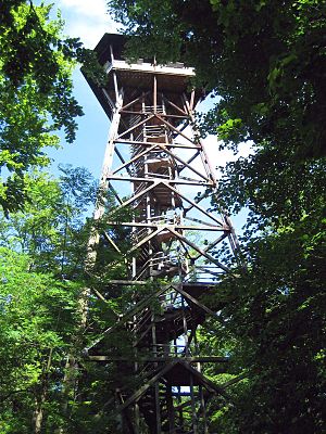
Loorenkopf
Distance: Approx. 2770 meters
Latitude and longitude: 47.36944444,8.59888889
Loorenkopf tower is a 33-metre (108 ft) high freestanding wood lattice tower on Adlisberg, north of Witikon in Zürich, Switzerland. It was built in 1954. The tower is owned by Zürich city and it is open to the public.
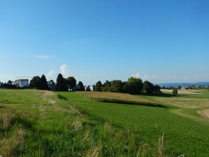
Pfaffhausen
Distance: Approx. 1538 meters
Latitude and longitude: 47.36666667,8.61666667
Pfaffhausen (also known as Pffaffhausen) is a settlement in the municipality of Fällanden in the canton of Zürich, Switzerland. It has an elevation of 597 m, and lies in the valley between the northern flank of the Öschbrig and the southeastern slope of the Adlisberg. Pfaffhausen borders the Zürich quarter of Witikon to the west, the settlement of Binz (belonging to Maur) to the south, and the settlement of Benglen, also part of Fällanden, to the east.

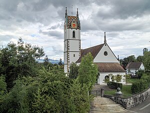
Greifensee Reformed Church
Distance: Approx. 3668 meters
Latitude and longitude: 47.36489,8.67691
Reformierte Kirche Greifensee (native German name, literally: Greifensee Reformed Church or commonly Gallus-Kapelle Im Städtli), is a church and a listed heritage building in the municipality of Greifensee, Canton of Zürich, Switzerland.

Adlisberg
Mountain in Zürich, Switzerland
Distance: Approx. 3229 meters
Latitude and longitude: 47.37055556,8.59277778
Adlisberg, with an elevation of 701 metres (2,300 ft), is a wooded mountain in Switzerland overlooking Zürichsee (Lake Zürich) to the northwest near the Zürichberg.

Greifensee Castle
Distance: Approx. 3581 meters
Latitude and longitude: 47.365037,8.675652
Greifensee Castle (‹See Tfd›German: Schloss Greifensee) is a castle in the municipality of Greifensee and the canton of Zurich in Switzerland. It was probably built by the House of Rapperswil and is a Swiss heritage site of national significance.
Öschbrig
Mountain in Switzerland
Distance: Approx. 1237 meters
Latitude and longitude: 47.35833333,8.61388889
Öschbrig (also known as Oetlisberg) with an elevation of 696 metres (2,283 ft), is a wooded mountain in Switzerland overlooking to the east Zürichsee (Lake Zürich).

Forch railway station
Railway station in Switzerland
Distance: Approx. 3695 meters
Latitude and longitude: 47.32532,8.64794
Forch is a railway station in the Swiss canton of Zürich and the municipality of Küsnacht. It is the principal intermediate station and headquarters of the Forchbahn (FB), which is operated as Zürich S-Bahn service S18 and provides links to the city of Zürich and the nearby village of Esslingen. The station is operated by the Forchbahn, and serves the village of Forch.
Zürich Rehalp railway station
Railway station on the edge of the Swiss city of Zurich
Distance: Approx. 3592 meters
Latitude and longitude: 47.35102694,8.58297889
Zürich Rehalp railway station (‹See Tfd›German: Bahnhof Zürich Rehalp) is a railway station and tram stop in the Swiss canton of Zürich, on the boundary between the city of Zürich and the municipality of Zollikon. The station is located on the line of the Forchbahn (FB), which is operated as Zürich S-Bahn service S18. The station is operated by Verkehrsbetriebe Zürich and Forchbahn AG and is the first true railway station on the S18 outbound from its city terminus at Zürich Stadelhofen FB. Between Stadelhofen and a point immediately to the city side of Rehalp station, the S18 operates over the tracks of the Zürich tram network, stopping at selected tram stops.
Weather in this IP's area
broken clouds
8 Celsius
8 Celsius
8 Celsius
9 Celsius
1018 hPa
88 %
1018 hPa
943 hPa
10000 meters
1.54 m/s
75 %
07:30:04
18:57:19