Country:
 USA
USARegion:
City:
Latitude and Longitude:
Time Zone:
Postal Code:
IP information under different IP Channel
ip-api
Country
Region
City
ASN
Time Zone
ISP
Blacklist
Proxy
Latitude
Longitude
Postal
Route
IPinfo
Country
Region
City
ASN
Time Zone
ISP
Blacklist
Proxy
Latitude
Longitude
Postal
Route
MaxMind
Country
Region
City
ASN
Time Zone
ISP
Blacklist
Proxy
Latitude
Longitude
Postal
Route
Luminati
Country
USRegion
ak
City
wasilla
ASN
Time Zone
America/Anchorage
ISP
MTAONLINE-AS
Latitude
Longitude
Postal
db-ip
Country
Region
City
ASN
Time Zone
ISP
Blacklist
Proxy
Latitude
Longitude
Postal
Route
ipdata
Country
Region
City
ASN
Time Zone
ISP
Blacklist
Proxy
Latitude
Longitude
Postal
Route
Popular places and events near this IP address

Tanaina, Alaska
CDP in Alaska, United States
Distance: Approx. 4444 meters
Latitude and longitude: 61.62416667,-149.43277778
Tanaina is a census-designated place (CDP) in the Matanuska-Susitna Borough in the U.S. state of Alaska. Located 4 miles north from Wasilla, it is part of the Anchorage, Alaska Metropolitan Statistical Area. At the 2020 census the population was 8,817, up from 8,197 in 2010.
Twindly Bridge Charter School
School in Wasilla, Alaska, United States
Distance: Approx. 4063 meters
Latitude and longitude: 61.61444444,-149.44944444
Twindly Bridge Charter School (TBCS) is a charter school located in the Matanuska-Susitna Borough School District in Wasilla, Alaska. It serves grades K-12. It has an indoor gym that has archery and air pistol shooting.
Wasilla High School
Public secondary school in Wasilla, Alaska, United States
Distance: Approx. 1733 meters
Latitude and longitude: 61.58861,-149.42861
Wasilla High School (WHS) is a public secondary school in Wasilla, Alaska, United States, serving students in grades 9–12. The school is part of the Matanuska-Susitna Borough School District, with admission based primarily on the locations of students' homes. The school earned widespread media attention in 2008 following former pupil Governor Sarah Palin's nomination as the Republican vice-presidential running mate to John McCain in the 2008 United States presidential election.
Wasilla Assembly of God
Church in Alaska , United States
Distance: Approx. 3545 meters
Latitude and longitude: 61.57156,-149.45282
The Wasilla Assembly of God is a Pentecostal church in the town of Wasilla, Alaska. It is affiliated with the Assemblies of God USA. The church gained national attention in 2008 when United States presidential candidate Senator John McCain chose Alaska Governor Sarah Palin, an attendee of the church until 2002, as his running mate in the 2008 election.

Lake Lucille
Lake in the state of Alaska, United States
Distance: Approx. 4275 meters
Latitude and longitude: 61.57472222,-149.47138889
Lake Lucille is a 350-acre (1.4 km2) lake within the municipal limits of Wasilla, Alaska, located at 61°34′N 149°28′W. Most of the lake shoreline is private property (i.e., not incorporated into the City of Wasilla), and many residents have docks for swimming, boating, or docking floatplanes. There is also a city park with a campground and boat launch. "Lake Lucille is basically a dead lake -- it can't support a fish population" according to Michelle Church, a local environmentalist.

Wasilla, Alaska
City in Alaska, United States
Distance: Approx. 3088 meters
Latitude and longitude: 61.58166667,-149.4525
Wasilla (Dena'ina: Benteh) is a city in Matanuska-Susitna Borough, Alaska, United States, and the fourth-largest city in Alaska. It is located on the northern point of Cook Inlet in the Matanuska-Susitna Valley of the southcentral part of the state. The city's population was 9,054 at the 2020 census, up from 7,831 in 2010.

Wasilla Depot
Distance: Approx. 1765 meters
Latitude and longitude: 61.57861,-149.42228
The Wasilla Depot was built in 1917 in Wasilla, Alaska. It was designed and built by the Alaska Engineering Commission, a federal agency charged with building Alaska's railways. The structure, located at the corner of Parks Highway and Main Street, was restored by the Lions Clubs and the Wasilla Chamber of Commerce.

Wasilla Elementary School
United States historic place
Distance: Approx. 2418 meters
Latitude and longitude: 61.58288,-149.4401
The Wasilla Elementary School, located near the corner of East Swanson Avenue and North Boundary Street in Wasilla, Alaska is a historic one-room school that was built in 1917. It was Wasilla's first school, and served as its primary school until 1934 when a larger school was built. It is 22 by 36 feet (6.7 m × 11.0 m) in dimension.
Wasilla Community Hall
United States historic place
Distance: Approx. 2468 meters
Latitude and longitude: 61.58265,-149.44095
The Wasilla Community Hall, also known as the Wasilla Museum, now hosting the Dorothy G. Page Museum, is located at 323 Main Street in Wasilla, Alaska. The museum is located in a log building constructed in 1931 to serve as a community center. The exterior of the building was left largely as-is when it was converted to a museum in 1967.
Blanche and Oscar Tryck House
Historic house in Alaska, United States
Distance: Approx. 2659 meters
Latitude and longitude: 61.58133,-149.44392
The Blanche and Oscar Tryck House is a historic house on North Knik Street (at the northwest corner with the Parks Highway) in Wasilla, Alaska. Built sometime before 1916 at Knik, it was the first house in Wasilla when the community was established, moved there by the Trycks in 1917. It is a single-story wood-frame structure, roughly rectangular in shape, with a concrete foundation and a corrugated metal gable roof configured to capture rainwater for laundry and other uses.

Teeland's Country Store
United States historic place
Distance: Approx. 2422 meters
Latitude and longitude: 61.58239,-149.43991
Teeland's Country Store, also known as Herning's Place and Knik Trading Company, is a historic retail establishment located at the corner of East Herning Avenue and North Boundary Street in Wasilla, Alaska. The oldest portion of this wood-frame building is a log structure at the back whose construction dates to 1905. Originally located at Knik, this log structure, then also used as a store, was moved to the newly established town of Wasilla in 1917 by its builder, O. G. Herning.
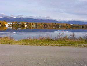
Wasilla Lake
Lake in the state of Alaska, United States
Distance: Approx. 216 meters
Latitude and longitude: 61.58722222,-149.3925
Wasilla Lake is a lake in Wasilla, Alaska, named by workers constructing the Alaska Railroad after a nearby creek named Wasilla Creek. The lake shore is the site of a city park, Newcomb Park. It is the northern terminus of the Seven-Mile Canoe Trail, the other end being at Finger Lake.
Weather in this IP's area
overcast clouds
12 Celsius
11 Celsius
11 Celsius
14 Celsius
1005 hPa
75 %
1005 hPa
993 hPa
10000 meters
3.6 m/s
60 degree
100 %
07:28:07
20:16:27