Country:
 Netherlands
Region:
City:
Latitude and Longitude:
Time Zone:
Postal Code:
IP information under different IP Channel
ip-api
Country
Region
City
ASN
Time Zone
ISP
Blacklist
Proxy
Latitude
Longitude
Postal
Route
IPinfo
Country
Region
City
ASN
Time Zone
ISP
Blacklist
Proxy
Latitude
Longitude
Postal
Route
MaxMind
Country
Region
City
ASN
Time Zone
ISP
Blacklist
Proxy
Latitude
Longitude
Postal
Route
Luminati
Country
NLASN
Time Zone
Europe/Amsterdam
ISP
Accenture B. V.
Latitude
Longitude
Postal
db-ip
Country
Region
City
ASN
Time Zone
ISP
Blacklist
Proxy
Latitude
Longitude
Postal
Route
ipdata
Country
Region
City
ASN
Time Zone
ISP
Blacklist
Proxy
Latitude
Longitude
Postal
Route
Popular places and events near this IP address

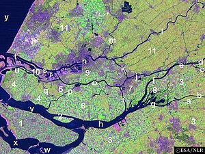
Nieuwe Waterweg
Ship canal in the Netherlands
Distance: Approx. 4394 meters
Latitude and longitude: 51.94194444,4.19138889
The Nieuwe Waterweg ("New Waterway") is a ship canal in the Netherlands from het Scheur (a branch of the Rhine-Meuse-Scheldt delta) west of the town of Maassluis to the North Sea at Hook of Holland: the Maasmond, where the Nieuwe Waterweg connects to the Maasgeul. It is the artificial mouth of the river Rhine. The Nieuwe Waterweg, which opened in 1872 and has a length of approximately 20.5 kilometres (12.7 mi), was constructed to keep the city and port of Rotterdam accessible to seafaring vessels as the natural Meuse-Rhine branches silted up.

Maasland
Village in Netherlands
Distance: Approx. 2322 meters
Latitude and longitude: 51.93333333,4.26666667
Maasland (population: 6,844) is a village in the western Netherlands, in the province of South Holland. It lies in the municipality (gemeente) of Midden-Delfland and covers an area of 24.42 km2 (of which 0.64 km2 water). It is located in a countryside area with dairy farms that is surrounded by various urban concentrations, namely the city of Rotterdam, the municipality of Westland (area with intensive greenhouse horticulture activities), and the towns of Vlaardingen and Maassluis.

Maassluis
Town and municipality in South Holland, Netherlands
Distance: Approx. 1777 meters
Latitude and longitude: 51.93333333,4.23333333
Maassluis (Dutch pronunciation: [maːˈslœys] ) is a town in the western Netherlands, in the province of South Holland. The municipality had a population of 33,567 in 2021 and covered 10.12 km2 (3.91 sq mi) of which 1.64 km2 (0.63 sq mi) was water. It received town rights in 1811.

Rozenburg
Town in South Holland province of the Netherlands
Distance: Approx. 2117 meters
Latitude and longitude: 51.9,4.25
Rozenburg (Dutch pronunciation: [ˈroːzə(m)bʏr(ə)x] ) is a town and former municipality in the western Netherlands, in the province of South Holland. The municipality had a population of 13,173 in 2004, and covers an area of 6.50 km2 (of which 1.99 km2 water). It was the second-smallest municipality in the Netherlands in area (behind Bennebroek).

Scheur
River in South Holland, Netherlands
Distance: Approx. 394 meters
Latitude and longitude: 51.915,4.242
The Scheur (Dutch pronunciation: [sxøːr] ; Dutch for "The Rip") is a branch of the Rhine-Meuse delta in South Holland, Netherlands, that flows west from the confluence of the Oude Maas and Nieuwe Maas branches past the towns of Rozenburg and Maassluis. It continues as the Nieuwe Waterweg (New Waterway) to the North Sea. Originally, the Scheur was the northern branch of the river around Rozenburg island and curved south a few kilometres past Maassluis to join the Nieuwe Maas again in the Maasmond ("Mouth of Meuse") estuary near Den Briel.
Brielse Meer
Lake in South Holland province, the Netherlands
Distance: Approx. 3925 meters
Latitude and longitude: 51.90555556,4.18972222
The Brielse Meer ("Lake Den Briel") is a long, narrow lake between the Dutch estuary islands of Voorne and Rozenburg in the province of South Holland. The lake takes its name from Den Briel, a town on its shore. It was formerly a branch of the Meuse known as the Brielse Maas (Den Briel Meuse), which ran from the Botlek strait near Rotterdam into the North Sea.

Zwartewaal
Town in South Holland, Netherlands
Distance: Approx. 4309 meters
Latitude and longitude: 51.88333333,4.21666667
Zwartewaal is a village in the Dutch province of South Holland, The Netherlands. It is a part of the municipality of Voorne aan Zee and lies about 5 km south of Maassluis.

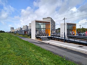
Maassluis Centrum metro station
Metro station in Maassluis, the Netherlands
Distance: Approx. 738 meters
Latitude and longitude: 51.91805556,4.25361111
Maassluis Centrum, formerly Maassluis, is a metro station in Maassluis, The Netherlands.
Maassluis West metro station
Metro station in Maassluis, the Netherlands
Distance: Approx. 913 meters
Latitude and longitude: 51.92555556,4.23611111
Maassluis West is a metro station in Maassluis, Netherlands.

MV Greenpeace
Distance: Approx. 350 meters
Latitude and longitude: 51.916617,4.24698
The MV Greenpeace (formerly (1959–1977) and since 2002 known as the Elbe) was a Greenpeace ship built in 1959 as an oceangoing tug/salvage vessel. She was purchased by Greenpeace in 1985 from the Maryland Pilotage Company, the vessel then being named MV Maryland, and transferred back to the Netherlands to be refitted with modern equipment before being recommissioned. She took over from the first Rainbow Warrior, which had been sunk in 1985 by French commandos.

Rozenburg wind wall
Distance: Approx. 2302 meters
Latitude and longitude: 51.901402,4.22404
Rozenburg wind wall in Rozenburg, Netherlands, is a wall built to block wind from entering the Calandkanaal, and ease the passage of large cargo ships through the narrow canal, particularly through the Calandbrug bridge. The wall blocks about 75% of the wind and allows the ships to pass smoothly. The wall is 1600 meters long and it is made up of 125 rectangular and cylindrical slabs, each about 25 meters tall and 18 meters wide.

Blankenburg (Rozenburg)
Former village on Rozenburg, Netherlands
Distance: Approx. 2117 meters
Latitude and longitude: 51.9,4.25
Blankenburg is a former village that was located on the Dutch island of Rozenburg in the province of South Holland. It was located to the west of Rotterdam and to the southeast of the village of Rozenburg and was part of the Blankenburg island polder of the same name, which was created around 1600 by migrants from Blankenberge in Flanders. Soon after, it formed a single island with Rozenburg and a few embankments in the Maas estuary.
Weather in this IP's area
light intensity drizzle
15 Celsius
15 Celsius
14 Celsius
16 Celsius
1015 hPa
87 %
1015 hPa
1015 hPa
10000 meters
5.14 m/s
170 degree
100 %
08:14:53
18:40:40