Country:
 Netherlands
Region:
City:
Latitude and Longitude:
Time Zone:
Postal Code:
IP information under different IP Channel
ip-api
Country
Region
City
ASN
Time Zone
ISP
Blacklist
Proxy
Latitude
Longitude
Postal
Route
IPinfo
Country
Region
City
ASN
Time Zone
ISP
Blacklist
Proxy
Latitude
Longitude
Postal
Route
MaxMind
Country
Region
City
ASN
Time Zone
ISP
Blacklist
Proxy
Latitude
Longitude
Postal
Route
Luminati
Country
NLASN
Time Zone
Europe/Amsterdam
ISP
BusinessConnect BV
Latitude
Longitude
Postal
db-ip
Country
Region
City
ASN
Time Zone
ISP
Blacklist
Proxy
Latitude
Longitude
Postal
Route
ipdata
Country
Region
City
ASN
Time Zone
ISP
Blacklist
Proxy
Latitude
Longitude
Postal
Route
Popular places and events near this IP address
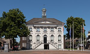
Zundert
Municipality in North Brabant, Netherlands
Distance: Approx. 938 meters
Latitude and longitude: 51.46666667,4.66666667
Zundert (Dutch pronunciation: [ˈzʏndərt] ) is a municipality and town in the south of the Netherlands bordering Belgium, in the province of North Brabant. Zundert is the birthplace of Post-Impressionist painter Vincent van Gogh.

Rijsbergen
Town in North Brabant, Netherlands
Distance: Approx. 5067 meters
Latitude and longitude: 51.51694444,4.69611111
Rijsbergen a town in the municipality of Zundert in the southern Netherlands. In the town used to be an AC (Aanmeldcentrum, i.e. Asylum Request Center).

Sprundel
Village in North Brabant, Netherlands
Distance: Approx. 8882 meters
Latitude and longitude: 51.53638889,4.59611111
Sprundel is a village in the southern Netherlands, in the Rucphen municipality. In the past it was the main village of the region, with roads to Roosendaal to the west, Breda to the east, Rotterdam to the north and Antwerp to the south. The village was first mentioned in 1282 as "Hermano filio Nekers de Sprundele".

Galder, Netherlands
Village in North Brabant, Netherlands
Distance: Approx. 8395 meters
Latitude and longitude: 51.515,4.77583333
Galder is a village in the Dutch province of North Brabant. It is located in the municipality of Alphen-Chaam 8 km south of the city of Breda.
Heikant, Rucphen
Distance: Approx. 7075 meters
Latitude and longitude: 51.52972222,4.6275
Heikant is a hamlet in the municipality of Rucphen, in the Dutch province of North Brabant. It is located about 2 km southeast of Sprundel.
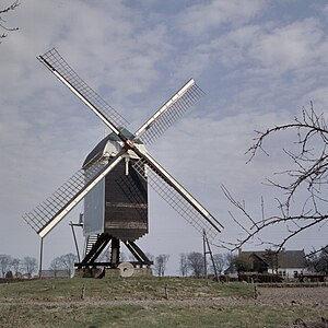
De Akkermolen
Dutch monumental windmill
Distance: Approx. 806 meters
Latitude and longitude: 51.478853,4.66715
De Akkermolen (Dutch pronunciation: [də ˈʔɑkərmoːlə(n)]; English: The Field Mill) is a 17th-century windmill in Zundert, Netherlands. Built around 1605 to replace an earlier windmill, it was used as a gristmill until it was severely damaged in 1950. The mill was bought by the local government and restored in 1961, and it was listed as a national heritage site in 1974.
Meer, Antwerp
Village in Flemish Region
Distance: Approx. 5315 meters
Latitude and longitude: 51.445,4.7364
Meer is a village in the Belgian municipality of Hoogstraten in the province of Antwerp. As of 2021, it has 3,542 inhabitants.

Meerle
Village in Flemish Region
Distance: Approx. 8931 meters
Latitude and longitude: 51.4733,4.8036
Meerle is a village in the Belgian municipality of Hoogstraten in the province of Antwerp. As of 2021, it has about 3,871 inhabitants.

Minderhout
Village in Flemish Community, Belgium
Distance: Approx. 8703 meters
Latitude and longitude: 51.4175,4.7625
Minderhout is a village in the Belgian municipality of Hoogstraten in the province of Antwerp close to the border with the Netherlands. As of 2021, it has about 4,420 inhabitants.
Meersel-Dreef
Village in Hoogstraten, Belgium
Distance: Approx. 7458 meters
Latitude and longitude: 51.4978,4.775
Meersel-Dreef is a village in the Belgian municipality of Hoogstraten in the province of Antwerp, Belgium. Meersel-Dreef is the northernmost point of Belgium, and directly borders the Netherlands.
Loenhout
Village in Flemish Region
Distance: Approx. 8534 meters
Latitude and longitude: 51.3992,4.6439
Loenhout is a village and deelgemeente (sub-municipality) of the municipality of Wuustwezel in the province of Antwerp, Belgium. The village is located near the Dutch border, and about 26 kilometres (16 mi) north-east of the city of Antwerp.

Strijbeek
Village in North Brabant, Netherlands
Distance: Approx. 9022 meters
Latitude and longitude: 51.50138889,4.79694444
Strijbeek is a village in the Dutch province of North Brabant. It is located in the municipality of Alphen-Chaam 11 km south of the city of Breda.
Weather in this IP's area
overcast clouds
16 Celsius
16 Celsius
15 Celsius
16 Celsius
1014 hPa
90 %
1014 hPa
1014 hPa
10000 meters
2.94 m/s
5.89 m/s
345 degree
100 %
08:10:38
18:41:49