Country:
Region:
City:
Latitude and Longitude:
Time Zone:
Postal Code:
IP information under different IP Channel
ip-api
Country
Region
City
ASN
Time Zone
ISP
Blacklist
Proxy
Latitude
Longitude
Postal
Route
Luminati
Country
Region
12
City
krakow
ASN
Time Zone
Europe/Warsaw
ISP
Bestconnect
Latitude
Longitude
Postal
IPinfo
Country
Region
City
ASN
Time Zone
ISP
Blacklist
Proxy
Latitude
Longitude
Postal
Route
db-ip
Country
Region
City
ASN
Time Zone
ISP
Blacklist
Proxy
Latitude
Longitude
Postal
Route
ipdata
Country
Region
City
ASN
Time Zone
ISP
Blacklist
Proxy
Latitude
Longitude
Postal
Route
Popular places and events near this IP address

Piłsudski's Mound
Tumulus in Krakow, Poland, finished in 1937
Distance: Approx. 3129 meters
Latitude and longitude: 50.056,19.84166667
Piłsudski's Mound (Polish: kopiec Piłsudskiego; also known as Independence Mound or Freedom Mound) is located in Kraków, Poland, and was established by the Polish nation in honor of Józef Piłsudski. An artificial mound, it was constructed between the years 1934 and 1937. It is located in the western part of Kraków, on the Sowiniec Heights, Kraków's VII District "Zwierzyniec".
Modlniczka
Village in Lesser Poland Voivodeship, Poland
Distance: Approx. 3664 meters
Latitude and longitude: 50.11666667,19.85
Modlniczka [mɔdlˈnit͡ʂka] is a village in the administrative district of Gmina Wielka Wieś, within Kraków County, Lesser Poland Voivodeship, in southern Poland. It lies approximately 9 km (6 mi) north-west of the regional capital Kraków.

Balice, Lesser Poland Voivodeship
Wieś in Lesser Poland Voivodeship, Poland
Distance: Approx. 3249 meters
Latitude and longitude: 50.08611111,19.79722222
Balice [baˈlit͡sɛ] is a village in the administrative district of Gmina Zabierzów, within Kraków County, Lesser Poland Voivodeship, in southern Poland. It lies approximately 4 kilometres (2 mi) south of Zabierzów and 11 km (7 mi) west of the city centre of Kraków. Balice is the home of the John Paul II International Airport.
Brzezie, Kraków County
Village in Lesser Poland Voivodeship, Poland
Distance: Approx. 3685 meters
Latitude and longitude: 50.11666667,19.83333333
Brzezie [ˈbʐɛʑɛ] is a village in the administrative district of Gmina Zabierzów, within Kraków County, Lesser Poland Voivodeship, in southern Poland. It lies approximately 4 kilometres (2 mi) east of Zabierzów and 10 km (6 mi) north-west of the regional capital Kraków.
Rząska
Village in Lesser Poland Voivodeship, Poland
Distance: Approx. 1890 meters
Latitude and longitude: 50.1,19.83333333
Rząska [ˈʐɔ̃ska] is a village in the administrative district of Gmina Zabierzów, within Kraków County, Lesser Poland Voivodeship, in southern Poland. It lies approximately 5 kilometres (3 mi) south-east of Zabierzów and 9 km (6 mi) north-west of the regional capital Kraków.
Szczyglice, Lesser Poland Voivodeship
Village in Lesser Poland Voivodeship, Poland
Distance: Approx. 2562 meters
Latitude and longitude: 50.1,19.81666667
Szczyglice [ʂt͡ʂɨˈɡlit͡sɛ] is a village in the administrative district of Gmina Zabierzów, within Kraków County, Lesser Poland Voivodeship, in southern Poland. It lies approximately 4 kilometres (2 mi) south-east of Zabierzów and 10 km (6 mi) north-west of the regional capital Kraków.
Rydlówka
Museum in Kraków, Poland
Distance: Approx. 2565 meters
Latitude and longitude: 50.08777778,19.87805556
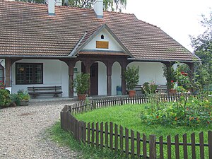
Regionalne Muzeum Młodej Polski "Rydlówka" is a museum in Kraków, Poland. It was constructed in 1894.

Kraków Mydlniki railway station
Railway station in Kraków, Poland
Distance: Approx. 1167 meters
Latitude and longitude: 50.0834,19.8589
Kraków Mydlniki is a railway station in the Bronowice district of Kraków, Poland, located in the neighbourhood of Mydlniki, northwest of the city centre. The station, with its historic building, lies within the Tenczynek Landscape Park (Tenczyński Park Krajobrazowy) protected area with numerous summer visitors, because the Park is also the location of a medieval Tenczyn Castle built as a seat of the powerful Tęczyński family. It fell into ruin during the Deluge in mid-17th century, after being pillaged and burned by Swedish-Brandenburgian forces looking for the Polish Crown Jewels and the rumored treasures of the Tęczyński family.

Kraków Zoo
Zoo in Kraków, Poland
Distance: Approx. 3441 meters
Latitude and longitude: 50.05361111,19.85055556
The Kraków Zoo (Polish: Ogród Zoologiczny w Krakowie) is located in Kraków, Poland and was established in 1929. It is home to over 1500 animals and about 260 species. The zoo is a member of the European Association of Zoos and Aquaria and the World Association of Zoos and Aquariums.

Bronowice, Kraków
Dzielnica of Kraków in Lesser Poland Voivodeship, Poland
Distance: Approx. 1721 meters
Latitude and longitude: 50.08333333,19.86666667
Bronowice is one of 18 districts of Kraków, located in the western part of the city. The name Bronowice comes from a village of same name that is now a part of the district. According to the Central Statistical Office data, the district's area is 9.56 square kilometres (3.69 square miles) and 24,014 people inhabit Bronowice.

Zwierzyniec, Kraków
Dzielnica of Kraków in Lesser Poland Voivodeship, Poland
Distance: Approx. 3290 meters
Latitude and longitude: 50.05825,19.86492222
Zwierzyniec is one of 18 districts of Kraków, located in the western part of the city. The name Zwierzyniec comes from a village of same name that is now a part of the district. According to the Central Statistical Office data, the district's area is 28.73 square kilometres (11.09 square miles) and 20 454 people inhabit Zwierzyniec.

Institute of Nuclear Physics of the Polish Academy of Sciences
Institute in Poland
Distance: Approx. 3453 meters
Latitude and longitude: 50.08922222,19.89027778
The (Henryka Niewodniczański) Institute of Nuclear Physics Polish Academy of Sciences is a research center in the field of nuclear physics of the Polish Academy of Sciences, located in Kraków. It was founded in 1955 by Henryk Niewodniczański. In 1988 the institute was named after Niewodniczański.
Weather in this IP's area
few clouds
5 Celsius
2 Celsius
3 Celsius
6 Celsius
1010 hPa
81 %
1010 hPa
984 hPa
10000 meters
4.12 m/s
240 degree
20 %
06:59:03
15:52:58
